world.wikisort.org - Portugal
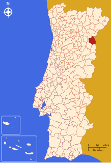
Figueira de Castelo Rodrigo (Portuguese pronunciation: [fiˈɣɐjɾɐ ðɨ kɐʃˈtɛlu ʁuˈðɾiɣu] (![]() listen)) is a municipality in the District of Guarda in Portugal. The population in 2011 was 6,260,[1] in an area of 508.57 km2.[2]
Located in the Riba Coa (near the River Coa), just like other municipalities around Riba Coa, such as Almeida, Meda, Pinhel and Sabugal. Known for its castle which is a listed National monument, as well as pine-wood forests and rolling hills.
listen)) is a municipality in the District of Guarda in Portugal. The population in 2011 was 6,260,[1] in an area of 508.57 km2.[2]
Located in the Riba Coa (near the River Coa), just like other municipalities around Riba Coa, such as Almeida, Meda, Pinhel and Sabugal. Known for its castle which is a listed National monument, as well as pine-wood forests and rolling hills.
Figueira de Castelo Rodrigo | |
|---|---|
Municipality | |
 Flag  Coat of arms | |
 | |
| Coordinates: 40°53′N 6°57′W | |
| Country | |
| Region | Centro |
| Intermunic. comm. | Beiras e Serra da Estrela |
| District | Guarda |
| Parishes | 10 |
| Government | |
| • President | Carlos Condesso (PSD) |
| Area | |
| • Total | 508.57 km2 (196.36 sq mi) |
| Population (2011) | |
| • Total | 6,260 |
| • Density | 12/km2 (32/sq mi) |
| Time zone | UTC±00:00 (WET) |
| • Summer (DST) | UTC+01:00 (WEST) |
| Local holiday | July 7 |
| Website | http://www.cm-fcr.pt |
The municipality borders the frontier with Spain, formed by the Águeda River, a tributary of the Douro, which it joins at Barca D'Alva, approximately 18 km north of Figueira de Castelo Rodrigo town.
The present Mayor is Carlos Condesso, elected by the Social Democratic Party. The municipal holiday is July 7.
Figueira de Castelo Rodrigo figures in José Saramago's 2008 novel The Elephant's Journey.[3]
Climate
Figueira de Castelo Rodrigo has a Mediterranean climate with cool, wet winters and hot, dry summers. Temperatures can easily surpass 35 °C (95 °F) in the summer and go below 0 °C (32 °F) in the winter. It is one of the coldest towns in Portugal in the winter. It registered a record low temperature of −12.6 °C (9.3 °F) on January 12, 1967, making it the fifth coldest temperature ever recorded in the country and the third coldest since 1960.[4]
| Climate data for Figueira de Castelo Rodrigo, 1961-1990, altitude: 635 m (2,083 ft) | |||||||||||||
|---|---|---|---|---|---|---|---|---|---|---|---|---|---|
| Month | Jan | Feb | Mar | Apr | May | Jun | Jul | Aug | Sep | Oct | Nov | Dec | Year |
| Record high °C (°F) | 22.6 (72.7) |
24.8 (76.6) |
29.4 (84.9) |
32.2 (90.0) |
34.8 (94.6) |
41.5 (106.7) |
40.6 (105.1) |
44.0 (111.2) |
41.4 (106.5) |
32.6 (90.7) |
25.3 (77.5) |
23.2 (73.8) |
44.0 (111.2) |
| Average high °C (°F) | 8.8 (47.8) |
10.9 (51.6) |
13.6 (56.5) |
15.8 (60.4) |
20.2 (68.4) |
25.4 (77.7) |
29.6 (85.3) |
29.3 (84.7) |
25.9 (78.6) |
19.2 (66.6) |
12.8 (55.0) |
9.0 (48.2) |
18.4 (65.1) |
| Daily mean °C (°F) | 4.5 (40.1) |
6.2 (43.2) |
8.1 (46.6) |
10.2 (50.4) |
13.7 (56.7) |
18.1 (64.6) |
21.3 (70.3) |
20.9 (69.6) |
18.4 (65.1) |
13.2 (55.8) |
7.9 (46.2) |
4.9 (40.8) |
12.3 (54.1) |
| Average low °C (°F) | 0.2 (32.4) |
1.5 (34.7) |
2.6 (36.7) |
4.6 (40.3) |
7.2 (45.0) |
10.8 (51.4) |
13.0 (55.4) |
12.5 (54.5) |
10.9 (51.6) |
7.2 (45.0) |
3.0 (37.4) |
0.8 (33.4) |
6.2 (43.2) |
| Record low °C (°F) | −12.6 (9.3) |
−12.0 (10.4) |
−9.6 (14.7) |
−5.6 (21.9) |
−4.1 (24.6) |
2.1 (35.8) |
4.5 (40.1) |
5.5 (41.9) |
1.6 (34.9) |
−7.6 (18.3) |
−8.1 (17.4) |
−9.6 (14.7) |
−12.6 (9.3) |
| Average rainfall mm (inches) | 67.3 (2.65) |
71.5 (2.81) |
44.4 (1.75) |
54.0 (2.13) |
48.6 (1.91) |
39.5 (1.56) |
21.8 (0.86) |
10.7 (0.42) |
36.6 (1.44) |
61.8 (2.43) |
70.2 (2.76) |
57.6 (2.27) |
584 (22.99) |
| Average relative humidity (%) | 86 | 83 | 77 | 75 | 70 | 65 | 61 | 62 | 64 | 76 | 83 | 86 | 74 |
| Mean monthly sunshine hours | 107 | 132 | 185 | 199 | 261 | 296 | 352 | 330 | 230 | 187 | 135 | 101 | 2,515 |
| Source: Instituto de Meteorologia[5][6][7] | |||||||||||||
Parishes
Administratively, the municipality is divided into 10 civil parishes (freguesias):[8]
- Algodres, Vale de Alfonsinho e Vilar de Amargo
- Almofala e Escarigo
- Castelo Rodrigo
- Cinco Vilas e Reigada
- Colmeal e Vilar Torpim
- Escalhão
- Figueira de Castelo Rodrigo
- Freixeda do Torrão, Quintã de Pêro Martins e Penha da Águia
- Mata de Lobos
- Vermiosa
Notable people
- João Pedro (born 1986) a retired professional footballer with over 470 club caps
See also
- Castelo Rodrigo IPR
- Castelo Rodrigo Castle
References
- Instituto Nacional de Estatística Archived November 15, 2016, at the Wayback Machine
- "Áreas das freguesias, concelhos, distritos e país". Archived from the original on 2018-11-05. Retrieved 2018-11-05.
- José Saramago, The Elephant's Journey, (translated by Margaret Jull Costa), Harvil Secker, London, 2010.
- "Atlas Climático Ibérico" (PDF). IPMA. Retrieved 13 June 2021.
- "Plano Municipal de Defesa da Floresta Contra Incêndios" (PDF). Vila Nova de Foz Côa Municipality. Retrieved 10 June 2021.
- "Plano de Gestão da Região hidrográfica do Douro" (PDF). APA. p. 184. Retrieved 25 June 2021.
- "Plano Municipal de Emergência de Proteção Civil de Almeida" (PDF). Câmara Municipal de Almeida. p. 6. Retrieved 4 October 2021.
- Diário da República. "Law nr. 11-A/2013, page 552 50" (pdf) (in Portuguese). Retrieved 22 July 2014.
External links
Authority control | |
|---|---|
| General | |
| National libraries | |
This Guarda location article is a stub. You can help Wikipedia by expanding it. |
На других языках
- [en] Figueira de Castelo Rodrigo
[es] Figueira de Castelo Rodrigo
Figueira de Castelo Rodrigo es una villa y municipio portugués perteneciente al distrito de Guarda, Región estadística del Centro (NUTS II) y comunidad intermunicipal Beiras y Sierra de la Estrella (NUTS III). La ciudad, sede del municipio, cuenta con cerca de 2300 habitantes, mientras que el municipio, que tiene 508,57 km² de superficie y 5148 habitantes de población (2021) está subdividido en 10 freguesias. Se encuentra comprendido dentro del parque natural del Duero Internacional.[ru] Фигейра-ди-Каштелу-Родригу
Фигейра-ди-Каштелу-Родригу (порт. Figueira de Castelo Rodrigo; [fi'gɐiɾɐ dɨ kɐʃ'tɛlu ʁu'dɾigu]) — муниципалитет в Португалии, входит в округ Гуарда. По старому административному делению входил в провинцию Бейра-Алта. Входит в экономико-статистический субрегион Бейра-Интериор-Норте, который входит в Центральный регион. Численность населения — 2,3 тыс. жителей (посёлок), 6,7 тыс. жителей (муниципалитет)а на 2006 год. Занимает площадь 508,57 км².Другой контент может иметь иную лицензию. Перед использованием материалов сайта WikiSort.org внимательно изучите правила лицензирования конкретных элементов наполнения сайта.
WikiSort.org - проект по пересортировке и дополнению контента Википедии