world.wikisort.org - Poland
Świebodzice (Polish: [ɕfjɛbɔˈd͡ʑit͡sɛ]; Silesian: Frybork; German: Freiburg) is a town in south-western Poland with 22,793 inhabitants (as of 2019[update]). It is situated in Świdnica County, Lower Silesian Voivodeship (from 1975–1998 it was in the former Wałbrzych Voivodeship).
Świebodzice | |
|---|---|
 Skyline with the towers of the town hall (on the left) and of the Saints Peter and Paul Church (on the right) | |
 Flag  Coat of arms | |
 Świebodzice | |
| Coordinates: 50°52′N 16°20′E | |
| Country | |
| Voivodeship | Lower Silesian |
| County | Świdnica |
| Gmina | Świebodzice (urban gmina) |
| Government | |
| • Mayor | Paweł Ozga |
| Area | |
| • Total | 30.45 km2 (11.76 sq mi) |
| Population (2019-06-30[1]) | |
| • Total | 22,793 |
| • Density | 750/km2 (1,900/sq mi) |
| Time zone | UTC+1 (CET) |
| • Summer (DST) | UTC+2 (CEST) |
| Postal code | 58-160 |
| Car plates | DSW |
| Website | https://www.swiebodzice.pl |
The town is situated close to Książ Castle, which during World War II, together with the cave complex, was expanded to create private quarters for Adolf Hitler.
The town dates back to the medieval Kingdom of Poland. It was granted town rights by 1279. During World War II, the Germans established a subcamp of the Gross-Rosen concentration camp in the town.[2] In 1957 Pełcznica, and in 1973 Ciernie, were included within the town limits as its new districts.
Sports
Victoria Świebodzice football club is based in Świebodzice.
Notable people
- Gustav Becker (1819–1885), German clockmaker
- Martin Kirschner (1842–1912), Mayor of Berlin
- Jan Mikulicz-Radecki (1850–1905), Polish surgeon, one of the pioneers of antiseptics and aseptic techniques
- Alfred Zucker (1852–1913), German architect
- Wilhelm Niepelt (1862–1936), German scientist
- Emil Krebs (1867–1930), German scientist, noted polyglot who spoke a total of 68 languages at the time of his death
- Hartmut Kilger (born 1943), President of the German Lawyer's Association (2003–2009)
- Anna Zalewska (born 1965), politician, Minister of National Education of Poland
- Krzysztof Stelmach (born 1967), former Polish volleyball player with 274 games played for the Poland men's national volleyball team
- Jarosław Krzyżanowski (born 1975), retired Polish footballer
- Eliza Surdyka (born 1977), Polish Olympic cross-country skier
- Marcin Kokoszka (born 1984), Polish footballer
- Paweł Fajdek (born 1989), Polish hammer-thrower
Twin towns – sister cities
Świebodzice is twinned with:[3]
Gallery
 Town hall
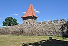 Medieval town walls
 Villa of Jan Mikulicz-Radecki
 Train station


References
- "Population. Size and structure and vital statistics in Poland by territorial division in 2019. As of 30th June". stat.gov.pl. Statistics Poland. 2019-10-15. Retrieved 2020-02-14.
- "Subcamps of KL Gross- Rosen". Gross-Rosen Museum in Rogoźnica. Retrieved 22 March 2020.
- "Miasta partnerskie". swiebodzice.pl (in Polish). Świebodzice. Retrieved 2020-03-03.
External links
- Jewish Community in Świebodzice on Virtual Shtetl
Gminas of Świdnica County | ||
|---|---|---|
| Urban gminas |
|  |
| Urban-rural gminas |
| |
| Rural gminas |
| |
Authority control | |
|---|---|
| General |
|
| National libraries | |
| Other |
|
This Świdnica County location article is a stub. You can help Wikipedia by expanding it. |
На других языках
- [en] Świebodzice
[ru] Свебодзице
Свебодзице (польск. Świebodzice, нем. Freiburg in Schlesien) — город в Польше, входит в Нижнесилезское воеводство, Свидницкий повят. Имеет статус городской гмины. Занимает площадь 30,45 км². Население — 23 233 человека (на 2004 год).Другой контент может иметь иную лицензию. Перед использованием материалов сайта WikiSort.org внимательно изучите правила лицензирования конкретных элементов наполнения сайта.
WikiSort.org - проект по пересортировке и дополнению контента Википедии