world.wikisort.org - Poland
Wysokie Mazowieckie County (Polish: powiat wysokomazowiecki) is a unit of territorial administration and local government (powiat) in Podlaskie Voivodeship, north-eastern Poland. It came into being on January 1, 1999, as a result of the Polish local government reforms passed in 1998. Its administrative seat and largest town is Wysokie Mazowieckie, which lies 49 kilometres (30 mi) south-west of the regional capital Białystok. The only other towns in the county are Ciechanowiec, lying 27 km (17 mi) south of Wysokie, Szepietowo, 6 km (4 mi) south of Wysokie, and as from 1 January 2011 Czyżew.
Wysokie Mazowieckie County
Powiat wysokomazowiecki | |
|---|---|
County | |
 Flag  Coat of arms | |
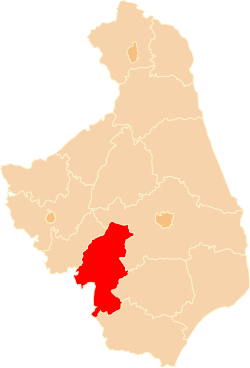 Location within the voivodeship | |
| Coordinates (Wysokie Mazowieckie): 52°55′9″N 22°30′52″E | |
| Country | |
| Voivodeship | Podlaskie |
| Seat | Wysokie Mazowieckie |
| Gminas | |
| Area | |
| • Total | 1,288.49 km2 (497.49 sq mi) |
| Population (2019) | |
| • Total | 57,051 |
| • Density | 44/km2 (110/sq mi) |
| • Urban | 18,849 |
| • Rural | 38,202 |
| Car plates | BWM |
| Website | http://wysokomazowiecki.pl/ |
The county covers an area of 1,288.49 square kilometres (497.5 sq mi). As of 2019 its total population was 57,051, out of which the population of Wysokie Mazowieckie was 9,415, that of Ciechanowiec 4,631, that of Czyżew 2,633, that of Szepietowo 2,170, and the rural population 38,202.[1]
Neighbouring counties
Wysokie Mazowieckie County is bordered by Białystok County and Bielsk County to the east, Siemiatycze County and Sokołów County to the south, and Ostrów Mazowiecka County and Zambrów County to the west.
Administrative division
The county is subdivided into 10 gminas (one urban, three urban-rural and six rural). These are listed in the following table, in descending order of population.
| Gmina | Type | Area (km2) |
Population (2019) |
Seat |
| Wysokie Mazowieckie | urban | 15.2 | 9,415 | |
| Gmina Ciechanowiec | urban-rural | 201.5 | 8,619 | Ciechanowiec |
| Gmina Szepietowo | urban-rural | 151.9 | 6,913 | Szepietowo |
| Gmina Czyżew | urban-rural | 123.4 | 6,367 | Czyżew |
| Gmina Sokoły | rural | 155.6 | 5,744 | Sokoły |
| Gmina Wysokie Mazowieckie | rural | 166.1 | 5,436 | Wysokie Mazowieckie * |
| Gmina Klukowo | rural | 123.8 | 4,375 | Klukowo |
| Gmina Nowe Piekuty | rural | 109.4 | 3,879 | Nowe Piekuty |
| Gmina Kobylin-Borzymy | rural | 119.6 | 3,223 | Kobylin-Borzymy |
| Gmina Kulesze Kościelne | rural | 115.5 | 3,080 | Kulesze Kościelne |
| * seat not part of the gmina | ||||
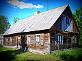
Gallery
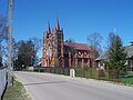

 Gmina Wysokie Mazowieckie
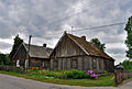
Mścichy


References
- GUS. "Population. Size and structure and vital statistics in Poland by territorial division in 2019. As of 30th June". stat.gov.pl. Retrieved 2020-09-14.
Gminas of Wysokie Mazowieckie County | ||
|---|---|---|
| Seat |
|  |
| Urban-rural gminas | ||
| Rural gminas | ||
Counties of Podlaskie Voivodeship | ||
|---|---|---|
| City counties |  | |
| Land counties |
| |
| Authority control |
|
|---|
На других языках
- [en] Wysokie Mazowieckie County
[ru] Высокомазовецкий повят
Высокомазовецкий повят (польск. Powiat wysokomazowiecki) — повят (район) в Польше, входит как административная единица в Подляское воеводство. Центр повята — город Высоке-Мазовецке. Занимает площадь 1288,49 км². Население — 58335 человек (на 30 июня 2015 года)[1].Другой контент может иметь иную лицензию. Перед использованием материалов сайта WikiSort.org внимательно изучите правила лицензирования конкретных элементов наполнения сайта.
WikiSort.org - проект по пересортировке и дополнению контента Википедии