world.wikisort.org - Poland
Wawer [ˈvavɛr] is one of the districts of Warsaw, located in the south-eastern part of the city. The Vistula river runs along its western border. Wawer became a district of Warsaw on 27 October 2002 (previously it was a part of Praga Południe district, and a municipality earlier).
Wawer | |
|---|---|
Warsaw District | |
 Coat of arms | |
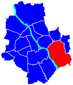 Location of Wawer within Warsaw | |
| Coordinates: 52°12′50″N 21°9′29″E | |
| Country | |
| Voivodeship | Masovian |
| County/City | Warsaw |
| Government | |
| • Mayor | Norbert Szczepański |
| Area | |
| • Total | 79.7 km2 (30.8 sq mi) |
| Population (2019) | |
| • Total | 77,205[1] |
| Time zone | UTC+1 (CET) |
| • Summer (DST) | UTC+2 (CEST) |
| Area code(s) | +48 22 |
| Website | wawer.warszawa.pl |
Wawer borders Praga Południe and Rembertów from the north, Wesoła from the east and Wilanów with Mokotów from the west (across the Vistula).
Boroughs
- Aleksandrów
- Anin
- Falenica
- Las
- Marysin Wawerski
- Miedzeszyn
- Międzylesie
- Nadwiśle
- Radość
- Sadul
- Wawer
- Zerzeń.
History
The name Wawer comes from the name of the Wawer inn (Karczma Wawer, currently known as Zajazd Napoleoński).[2] The oldest mention of the tavern comes from 1727, and the Wawer colony was established in 1838. First settlers appeared in 1839. During the November Uprising, the first and second Wawer battles took place here in early 1831.[3]
On the night of 26/27 December 1939 German occupants committed the Wawer massacre.
In 1951, Wawer was incorporated into Warsaw.[4]
In 1960, Wawer was incorporated into the Praga Południe district. In 1994 Wawer reappeared on the map of Warsaw as a commune (Warsaw - Wawer).[5] In 2002, the Wawer commune was transformed into a district.[6]
References
- "Powierzchnia i ludność w przekroju terytorialnym w 2019 roku. Tabl. 21 Powierzchnia, ludność oraz lokaty według gmi". stat.gov.pl. Główny Urząd Statystyczny. Retrieved 2 September 2020.
- "Zajazd Napoleoński - Historia". Retrieved 2 September 2020.
- Czerniawski, Jan, ed. (2007). Ważne daty z dziejów Wawra. W: Wawer i jego osiedla (in Polish) (1st ed.). Warsaw: Wydział Kultury dla Dzielnicy Wawer m.st. Warszawy. pp. 436–438. ISBN 978-83-921690-3-1.
- Czerniawski, Jan, ed. (2007). Dawny Wawer (1866-1951). Rys historyczno-statystyczny. W: Wawer i jego osiedla (in Polish) (1st ed.). Warsaw: Wydział Kultury dla Dzielnicy Wawer m.st. Warszawy. pp. 45–78. ISBN 978-83-921690-3-1.
- "Dz.U. z 1994 r. nr 48, poz. 195" (in Polish). Retrieved 2 September 2020.
- "Dz.U. z 2002 r. nr 41, poz. 361" (in Polish). Retrieved 2 September 2020.
External links
| Wikimedia Commons has media related to Wawer. |
- Urząd Dzielnicy Wawer
- Lokalny Serwis Informacyjny - Wawer
- Serwis "Moja dzielnica" Wawer
- Świdermajer - The characteristic architecture in the area
| Śródmieście |
| |
|---|---|---|
| Mokotów |
| |
| Praga |
| |
| Metro area |
| |
| ||
Authority control | |
|---|---|
| General | |
| National libraries | |
This Warsaw-related location article is a stub. You can help Wikipedia by expanding it. |
На других языках
- [en] Wawer
[ru] Вавер (Варшава)
Вавер[1] (польск. Wawer) — дзельница (район) Варшавы.Другой контент может иметь иную лицензию. Перед использованием материалов сайта WikiSort.org внимательно изучите правила лицензирования конкретных элементов наполнения сайта.
WikiSort.org - проект по пересортировке и дополнению контента Википедии