world.wikisort.org - Poland
Stalowa Wola County (Polish: powiat stalowowolski) is a unit of territorial administration and local government (powiat) in Subcarpathian Voivodeship, south-eastern Poland. It came into being on January 1, 1999, as a result of the Polish local government reforms passed in 1998. Its administrative seat and only town is Stalowa Wola, which lies 62 kilometres (39 mi) north of the regional capital Rzeszów.
Stalowa Wola County
Powiat stalowowolski | |
|---|---|
County | |
 Flag  Coat of arms | |
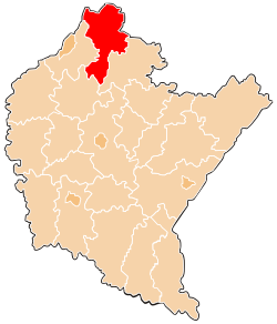 Location within the voivodeship | |
| Coordinates (Stalowa Wola): 50°35′N 22°3′E | |
| Country | |
| Voivodeship | |
| Seat | Stalowa Wola |
| Gminas | Total 6 (incl. 1 urban)
|
| Area | |
| • Total | 832.92 km2 (321.59 sq mi) |
| Population (2019) | |
| • Total | 103,293 |
| • Density | 120/km2 (320/sq mi) |
| • Urban | 60,799 |
| • Rural | 42,494 |
| Car plates | RST |
| Website | http://www.stalowowolski.pl/ |
The county covers an area of 832.92 square kilometres (321.6 sq mi). As of 2019[update] its total population is 103,293, out of which the population of Stalowa Wola is 60,799, and the rural population is 42,494.[1]
Neighbouring counties
Stalowa Wola County is bordered by Kraśnik County to the north, Janów Lubelski County to the east, Nisko County to the south-east, Kolbuszowa County to the south, and Tarnobrzeg County and Sandomierz County to the west.
Administrative division
The county is subdivided into six gminas (one urban and five rural). These are listed in the following table, in descending order of population.
| Gmina | Type | Area (km2) |
Population (2019) |
Seat |
| Stalowa Wola | urban | 83.0 | 60,799 | |
| Gmina Zaleszany | rural | 87.3 | 10,916 | Zaleszany |
| Gmina Pysznica | rural | 147.8 | 11,126 | Pysznica |
| Gmina Zaklików | urban-rural | 202.2 | 5,560 | Zaklików |
| Gmina Radomyśl nad Sanem | rural | 133.6 | 7,341 | Radomyśl nad Sanem |
| Gmina Bojanów | rural | 179.6 | 7,551 | Bojanów |
References
- GUS. "Population. Size and structure and vital statistics in Poland by territorial division in 2019. As of 30th June". stat.gov.pl. Retrieved 2020-09-14.
Gminas of Stalowa Wola County | ||
|---|---|---|
Seat: Stalowa Wola (urban gmina) | ||
| Rural gminas |
|  |
Counties of Podkarpackie Voivodeship | ||
|---|---|---|
| City counties |
|  |
| Land counties |
| |
Authority control | |
|---|---|
| General |
|
| National libraries | |
На других языках
[de] Powiat Stalowowolski
Der Powiat Stalowowolski ist ein Powiat (Kreis) in der polnischen Woiwodschaft Karpatenvorland. Der Powiat hat eine Fläche von 832,92 km², auf der 109.000 Einwohner leben.- [en] Stalowa Wola County
[ru] Сталёвовольский повят
Сталёвовольский повят (польск. Powiat stalowowolski) — повят (район) в Польше, входит как административная единица в Подкарпатское воеводство. Центр повята — город Сталёва-Воля. Занимает площадь 832,92 км². Население — 108 081 человек (на 30 июня 2015 года)[1].Другой контент может иметь иную лицензию. Перед использованием материалов сайта WikiSort.org внимательно изучите правила лицензирования конкретных элементов наполнения сайта.
WikiSort.org - проект по пересортировке и дополнению контента Википедии