world.wikisort.org - Poland
Ostrów Wielkopolski County (Polish: powiat ostrowski) is a unit of territorial administration and local government (powiat) in Greater Poland Voivodeship, west-central Poland. It came into being on January 1, 1999, as a result of the Polish local government reforms passed in 1998. Its administrative seat and largest town is Ostrów Wielkopolski, which lies 100 kilometres (62 mi) south-east of the regional capital Poznań. The county contains three other towns: Nowe Skalmierzyce, 22 km (14 mi) east of Ostrów Wielkopolski, Odolanów, 10 km (6 mi) south of Ostrów Wielkopolski, and Raszków, 8 km (5 mi) north of Ostrów Wielkopolski.
Ostrów Wielkopolski County
Powiat ostrowski | |
|---|---|
County | |
 Flag  Coat of arms | |
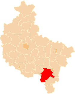 Location within the voivodeship | |
| Coordinates (Ostrów Wielkopolski): 51°39′N 17°42′E | |
| Country | |
| Voivodeship | |
| Seat | Ostrów Wielkopolski |
| Gminas | Total 8 (incl. 1 urban) |
| Area | |
| • Total | 1,160.65 km2 (448.13 sq mi) |
| Population (2006) | |
| • Total | 158,407 |
| • Density | 140/km2 (350/sq mi) |
| • Urban | 84,654 |
| • Rural | 73,753 |
| Car plates | POS |
| Website | http://www.powiat-ostrowski.pl |
The county covers an area of 1,160.65 square kilometres (448.1 sq mi). As of 2006 its total population is 158,407, out of which the population of Ostrów Wielkopolski is 72,577, that of Nowe Skalmierzyce is 5,080, that of Odolanów is 4,960, that of Raszków is 2,037, and the rural population is 73,753.
Neighbouring counties
Ostrów Wielkopolski County is bordered by Pleszew County to the north, the city of Kalisz and Kalisz County to the east, Ostrzeszów County to the south-east, Oleśnica County to the south-west, and Milicz County and Krotoszyn County to the west.
Administrative division
The county is subdivided into eight gminas (one urban, three urban-rural and four rural). These are listed in the following table, in descending order of population.
| Gmina | Type | Area (km²) |
Population (2006) |
Seat |
|---|---|---|---|---|
| Ostrów Wielkopolski | urban | 42.4 | 72,577 | |
| Gmina Ostrów Wielkopolski | rural | 207.0 | 17,969 | Ostrów Wielkopolski * |
| Gmina Nowe Skalmierzyce | urban-rural | 125.7 | 15,169 | Skalmierzyce |
| Gmina Odolanów | urban-rural | 136.0 | 13,867 | Odolanów |
| Gmina Przygodzice | rural | 163.5 | 11,320 | Przygodzice |
| Gmina Raszków | urban-rural | 134.5 | 11,275 | Raszków |
| Gmina Sieroszewice | rural | 163.5 | 9,605 | Sieroszewice |
| Gmina Sośnie | rural | 187.5 | 6,625 | Sośnie |
| * seat not part of the gmina | ||||
References
Gminas of Ostrów Wielkopolski County | ||
|---|---|---|
Seat: Ostrów Wielkopolski (urban gmina) | ||
| Urban-rural gminas |
|  |
| Rural gminas | ||
Counties of Greater Poland Voivodeship | ||
|---|---|---|
| City counties |  | |
| Land counties |
| |
Authority control | |
|---|---|
| General | |
| National libraries | |
На других языках
- [en] Ostrów County, Greater Poland Voivodeship
[ru] Острувский повет (Великопольское воеводство)
Острувский повет (Великопольское воеводство) (польск. Powiat ostrowski (wielkopolski)) — повет (район) в Польше, входит как административная единица в Великопольское воеводство. Центр повета — город Острув-Велькопольски. Занимает площадь 1160,65 км². Население — 161 435 человек (на 31 декабря 2015 года)[1].Другой контент может иметь иную лицензию. Перед использованием материалов сайта WikiSort.org внимательно изучите правила лицензирования конкретных элементов наполнения сайта.
WikiSort.org - проект по пересортировке и дополнению контента Википедии