world.wikisort.org - Poland
Koło County (Polish: powiat kolski) is a unit of territorial administration and local government (powiat) in Greater Poland Voivodeship, west-central Poland. It came into being on January 1, 1999, as a result of the Polish local government reforms passed in 1998. Its administrative seat and largest town is Koło, which lies 119 kilometres (74 mi) east of the regional capital Poznań. The county contains three other towns: Kłodawa, 21 km (13 mi) east of Koło, Dąbie, 19 km (12 mi) south-east of Koło, and Przedecz, 21 km (13 mi) north-east of Koło.
Koło County
Powiat kolski | |
|---|---|
County | |
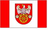 Flag 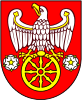 Coat of arms | |
 Location within the voivodeship | |
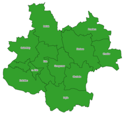 Division into gminas | |
| Coordinates (Koło): 52°12′N 18°38′E | |
| Country | |
| Voivodeship | |
| Seat | Koło |
| Gminas | Total 11 (incl. 1 urban)
|
| Area | |
| • Total | 1,011.03 km2 (390.36 sq mi) |
| Population (2010) | |
| • Total | 88,244 |
| • Density | 87/km2 (230/sq mi) |
| • Urban | 33,721 |
| • Rural | 54,880 |
| Car plates | PKL |
| Website | http://www.starostwokolskie.pl |
The county covers an area of 1,011.03 square kilometres (390.4 sq mi). As of 2010 its total population is 88,244, out of which the population of Koło is 23,034, that of Kłodawa is 6,829, that of Dąbie is 2,087, that of Przedecz is 1,771, and the rural population is 54,880.
History
Unit formed in Kalisz Governorate in 1867, since 1918 in the Second Polish Republic, German Landkreis Warthbrücken during World War II, later in Polish People's Republic, dissolved in 1975, reconstructed in 1998.
Neighbouring counties
Koło County is bordered by Radziejów County and Włocławek County to the north, Kutno County and Łęczyca County to the east, Poddębice County to the south-east, Turek County to the south, and Konin County to the west.
Administrative division
The county is subdivided into 11 gminas (one urban, three urban-rural and seven rural). These are listed in the following table, in descending order of population.
| Gmina | Type | Area (km²) |
Population (2006) |
Seat |
|---|---|---|---|---|
| Koło | urban | 13.9 | 23,034 | |
| Gmina Kłodawa | urban-rural | 129.0 | 13,307 | Kłodawa |
| Gmina Babiak | rural | 133.6 | 7,920 | Babiak |
| Gmina Koło | rural | 101.9 | 6,995 | Koło * |
| Gmina Kościelec | rural | 105.9 | 6,667 | Kościelec |
| Gmina Dąbie | urban-rural | 130.1 | 6,644 | Dąbie |
| Gmina Osiek Mały | rural | 87.3 | 5,866 | Osiek Mały |
| Gmina Grzegorzew | rural | 73.4 | 5,617 | Grzegorzew |
| Gmina Olszówka | rural | 81.5 | 4,757 | Olszówka |
| Gmina Przedecz | urban-rural | 76.5 | 4,319 | Przedecz |
| Gmina Chodów | rural | 78.0 | 3,475 | Chodów |
| * seat not part of the gmina | ||||
References
Gminas of Koło County | ||
|---|---|---|
| Seat |
|  |
| Urban-rural gminas | ||
| Rural gminas |
| |
Counties of Greater Poland Voivodeship | ||
|---|---|---|
| City counties |
|  |
| Land counties | ||
Authority control | |
|---|---|
| General |
|
| National libraries | |
На других языках
- [en] Koło County
[ru] Кольский повет
Кольский повет (польск. Powiat kolski) — повет (район) в Польше, входит как административная единица в Великопольское воеводство. Центр повета — город Коло. Занимает площадь 1011,03 км². Население — 88 399 человек (на 31 декабря 2015 года)[1].Другой контент может иметь иную лицензию. Перед использованием материалов сайта WikiSort.org внимательно изучите правила лицензирования конкретных элементов наполнения сайта.
WikiSort.org - проект по пересортировке и дополнению контента Википедии