world.wikisort.org - Poland
Drobin [ˈdrɔbʲin] is a town in Płock County, Masovian Voivodeship, Poland, with 2,778 inhabitants as of December 2021.[1]
Drobin | |
|---|---|
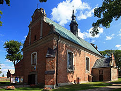
 Our Lady of the Rosary and Saint Stanislaus church in Drobin | |
 Coat of arms | |
 Drobin  Drobin | |
| Coordinates: 52°44′27″N 19°59′21″E | |
| Country | |
| Voivodeship | Masovian |
| County | Płock |
| Gmina | Drobin |
| First mentioned | 12th century |
| Town rights | 1511-1869, 1994 |
| Government | |
| • Mayor | Krzysztof Wielec (PSL) |
| Area | |
| • Total | 9.64 km2 (3.72 sq mi) |
| Population (31 December 2021[1]) | |
| • Total | 2,778 |
| • Density | 290/km2 (750/sq mi) |
| Time zone | UTC+1 (CET) |
| • Summer (DST) | UTC+2 (CEST) |
| Postal code | 09-210 |
| Area code(s) | +48 24 |
| Car plates | WPL |
| Website | https://www.drobin.pl |
History
The settlement was first mentioned in the 12th century, when it was part of Piast-ruled Poland. It was granted town rights in 1511 under the Jagiellonian dynasty. It was a private town of Polish nobility, administratively located in the Płock Voivodeship in the Greater Poland Province of the Polish Crown.
In 1869 Drobin lost its town status.[2] It was regained in 1994.
A battle was fought nearby on August 15, 1920, during the Polish-Soviet War.[3]
During the German occupation of Poland (World War II), the Germans renamed the town Reichenfeld to erase traces of Polish origin, and operated a forced labour camp there.[4]
Sports
The local football team is Skra Drobin.[5] It competes in the lower leagues.
References
- "Local Data Bank". Statistics Poland. Retrieved 2022-08-01. Data for territorial unit 1419054.
- "Prawa miejskie". drobin.pl (in Polish). Official website of Drobin. Retrieved 2022-08-01.
- Kowalski, Andrzej (1995). "Miejsca pamięci związane z Bitwą Warszawską 1920 r.". Niepodległość i Pamięć (in Polish). Muzeum Niepodległości w Warszawie (2/2 (3)): 129. ISSN 1427-1443.
- "Arbeitserziehungslager Reichenfeld". Bundesarchiv.de (in German). Retrieved 2 April 2021.
- "skradrobin.eu" (in Polish). Retrieved 2 April 2021.
External links
- Official site of Drobin (in Polish)
- Jewish Community in Drobin on Virtual Shtetl
На других языках
- [en] Drobin
[ru] Дробин
Дробин (польск. Drobin) — город в Польше, входит в Мазовецкое воеводство, Плоцкий повят. Имеет статус городско-сельской гмины. Занимает площадь 9,64 км². Население — 3016 человек (на 2004 год).Другой контент может иметь иную лицензию. Перед использованием материалов сайта WikiSort.org внимательно изучите правила лицензирования конкретных элементов наполнения сайта.
WikiSort.org - проект по пересортировке и дополнению контента Википедии
