world.wikisort.org - Poland
Domachowo [dɔmaˈxɔvɔ] is a village in the administrative district of Gmina Krobia, within Gostyń County, Greater Poland Voivodeship, in west-central Poland.[1] It lies approximately 6 kilometres (4 mi) north-east of Krobia, 8 km (5 mi) south of Gostyń, and 66 km (41 mi) south of the regional capital Poznań.
Domachowo | |
|---|---|
Village | |
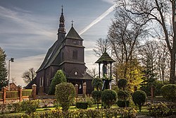
 Saint Michael Archangel church in Domachowo | |
 Domachowo | |
| Coordinates: 51°48′53″N 17°3′6″E | |
| Country | |
| Voivodeship | Greater Poland |
| County | Gostyń |
| Gmina | Krobia |
| Population | 472 |
| Time zone | UTC+1 (CET) |
| • Summer (DST) | UTC+2 (CEST) |
| Vehicle registration | PGS |
The village has a population of 472.
History

The area formed part of Poland since the establishment of the state in the 10th century. Domachowo was a private church village, administratively located in the Kościan County in the Poznań Voivodeship in the Greater Poland Province of the Kingdom of Poland.[2] The local landmark Church of Saint Michael Archangel was built in the 16th century. It was annexed by Prussia in the Second Partition of Poland in 1793. It was regained by Poles in 1807 and included within the short-lived Duchy of Warsaw, and after the duchy's dissolution in 1815, the village was reannexed by Prussia, and was also part of Germany from 1871. Following World War I, Poland regained independence and control of the village.
During the German occupation of Poland (World War II), in December 1939, the occupiers carried out first expulsions of Poles, who were then sent to a transit camp in nearby Gostyń, and eventually deported to the General Government in the more eastern part of German-occupied Poland.[3] Further expulsions of Poles were carried out by the German gendarmerie in 1940.[4] Expelled Poles were either deported to forced labour in Germany or enslaved as forced labour of new German colonists in the county.[4] Houses and farms of expelled Poles were handed over to new German colonists as part of the Lebensraum policy.[5]
References
- "Central Statistical Office (GUS) - TERYT (National Register of Territorial Land Apportionment Journal)" (in Polish). 2008-06-01.
- Atlas historyczny Polski. Wielkopolska w drugiej połowie XVI wieku. Część I. Mapy, plany (in Polish). Warszawa: Instytut Historii Polskiej Akademii Nauk. 2017. p. 1a.
- Wardzyńska, Maria (2017). Wysiedlenia ludności polskiej z okupowanych ziem polskich włączonych do III Rzeszy w latach 1939-1945 (in Polish). Warszawa: IPN. p. 159. ISBN 978-83-8098-174-4.
- Wardzyńska, p. 202
- Wardzyńska, p. 204
На других языках
- [en] Domachowo, Greater Poland Voivodeship
[ru] Домахово (Великопольское воеводство)
Домахо́во (польск. Domachowo) — село в Польше, входит в гмину Кробя Гостыньского повята Великопольского воеводства[1][2]. В 1975—1998 гг. входило в состав Лешненского воеводства. Как территориальная единица Домахово является солецтвом. Главой (солтысом) в 2011 году вновь избран Зигмунт Павляк[3], исполняющий эту обязанность с 1974 года[4]. Располагается село в 7 км к северо-востоку от центра гмины, Кроби, к югу от центра повята, Гостыни, и от центра воеводства, Познани. Численность населения — 477 человек (на 2009 год)[5]. Домахово является частью исторической области Бискупины, её жители — представители субэтнической группы бискупян[6]. Главная достопримечательность Домахова — костёл Святого Михаила Архангела, построенный в XVI веке[7].Другой контент может иметь иную лицензию. Перед использованием материалов сайта WikiSort.org внимательно изучите правила лицензирования конкретных элементов наполнения сайта.
WikiSort.org - проект по пересортировке и дополнению контента Википедии
