world.wikisort.org - Poland
Baborów [baˈbɔruf] (German: Bauerwitz) is a small town in southern Poland near Głubczyce, in the Opole Voivodeship, Głubczyce County, Gmina Baborów. As of December 2021, it has a population of 2,844.[3]
Baborów | |
|---|---|
 Saint Joseph Church | |
 Coat of arms | |
 Baborów  Baborów | |
| Coordinates: 50°9′28″N 17°58′48″E | |
| Country | |
| Voivodeship | Opole |
| County | Głubczyce |
| Gmina | Baborów |
| Government | |
| • Mayor | Tomasz Krupa |
| Area | |
| • Total | 11.86 km2 (4.58 sq mi) |
| Population | |
| • Total | 2,844 |
| • Density | 240/km2 (600/sq mi) |
| Time zone | UTC+1 (CET) |
| • Summer (DST) | UTC+2 (CEST) |
| Postal code | 48-120 |
| Area code | +48 77 |
| Car plates | OGL |
| Website | http://www.baborow.pl |
History
The first mention of the town comes from 1296 in which a wójt Jarosław is mentioned. The town was most likely founded by a Bohemian magnate, Bavor (Babor). Later it was part of an independent duchy, Habsburg-ruled Bohemia, the Kingdom of Prussia and from 1871 and 1945 also Germany. After the defeat of Nazi Germany in World War II it became part of Poland. It was granted town rights before 1340, although deprived of them from 1575 to 1718.[5] In the 18th century, Baborów belonged to the tax inspection region of Prudnik.[6]
According to the German census of 1890, the town had a population of 2,707, of which 2,220 (82%) were Czechs.[7] It marked the 19th-century linguistic border between German, Polish, and Czech.[8]
During World War II, the town, then known as Bauerwitz, was the base for two working parties (E288 and E398) of British and Commonwealth prisoners of war, under the administration of the German Stalag VIII-B/344 POW camp at Łambinowice (then known as Lamsdorf).[9] In January 1945, as the Soviet armies resumed their offensive and advanced from the east, the prisoners were marched by the Germans westward in the so-called Long March or Death March. Many of them died from the bitter cold and exhaustion. The lucky ones got far enough to the west to be liberated by the allied armies after some four months of travelling on foot in appalling conditions.[10] The town's German population was interned in Łambinowice camp, and expelled.[citation needed]
Notable people
- Kazimierz Szczygielski (1946–2019), Polish geographer and politician, member of the Polish Sejm.
International relations
Twin towns - sister cities
See twin towns of Gmina Baborów.
Gallery
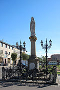 St. Mary column
 World War II memorial
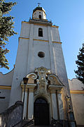 Assumption of Mary Church
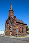 Sacred Heart Chapel


References
- "Kierownictwo Urzędu". www.baborow.pl (in Polish). Gmina Baborów. Retrieved 2022-08-22.
- "Local Data Bank". Statistics Poland. Retrieved 2022-08-22. Category K1, group G441, subgroup P1410. Data for territorial unit 1602014.
- "Local Data Bank". Statistics Poland. Retrieved 2022-08-22. Category K3, group G7, subgroup P1336. Data for territorial unit 1602014.
- "Local Data Bank". Statistics Poland. Retrieved 2022-08-22. Category K3, group G7, subgroup P2425. Data for territorial unit 1602014.
- Robert Krzysztofik, Lokacje miejskie na obszarze Polski. Dokumentacja geograficzno-historyczna, Katowice, 2007, p. 18-19 (in Polish)
- "Historia Powiatu Prudnickiego - Starostwo Powiatowe w Prudniku". 2020-11-16. Archived from the original on 16 November 2020. Retrieved 2021-12-07.
- "Deutsche Verwaltungsgeschichte Schlesien, Kreis Leobschuetz". treemagic.org. Archived from the original on 2019-07-28. Retrieved 2021-01-19.
- Weinhold, Karl (1887). Die Verbreitung und die Herkunft der Deutschen in Schlesien [The Spread and the Origin of Germans in Silesia] (in German). Stuttgart: J. Engelhorn. pp. 194.
- "Working Parties". Stalag VIIIB 344 Lamsdorf. Archived from the original on 20 January 2021. Retrieved 19 March 2020.
- "History". Stalag VIIIB 344 Lamsdorf. Retrieved 19 March 2020.
External links
- Official website (in Polish)
| Town and seat |  | |
|---|---|---|
| Villages | ||
Authority control | |
|---|---|
| General |
|
| National libraries | |
На других языках
[de] Baborów
Baborów [.mw-parser-output .IPA a{text-decoration:none}baˈbɔruf] (deutsch Bauerwitz; tschechisch Bavorov) ist eine Ortschaft in Oberschlesien. Sie ist Sitz der gleichnamigen Stadt-und-Land-Gemeinde mit etwa 6100 Einwohnern im Powiat Głubczycki in der Woiwodschaft Oppeln in Polen.- [en] Baborów
[ru] Баборув
Баборув (польск. Baborów, нем. Bauerwitz) — город в Польше, входит в Опольское воеводство, Глубчицкий повят. Имеет статус городско-сельской гмины. Занимает площадь 11,73 км². Население — 3227 человек (на 2004 год).Другой контент может иметь иную лицензию. Перед использованием материалов сайта WikiSort.org внимательно изучите правила лицензирования конкретных элементов наполнения сайта.
WikiSort.org - проект по пересортировке и дополнению контента Википедии