world.wikisort.org - Philippines
Taytay, officially the Municipality of Taytay (Tagalog: Bayan ng Taytay IPA: [taɪ'taɪ]), is a 1st class municipality in the province of Palawan, Philippines. According to the 2020 census, it has a population of 83,357 people. [3]
Taytay | |
|---|---|
Municipality | |
| Municipality of Taytay | |
 Panoramic | |
 Seal | |
| Motto(s): Taytay, Una sa Lahat! | |
| Anthem: Estrella Del Norte Bayan Kong Taytay | |
 Map of Palawan with Taytay highlighted | |
OpenStreetMap  | |
 Taytay Location within the Philippines | |
| Coordinates: 10°49′N 119°31′E | |
| Country | Philippines |
| Region | Mimaropa |
| Province | Palawan |
| District | 1st district |
| Founded | 1623 |
| Barangays | 31 (see Barangays) |
| Government | |
| • Type | Sangguniang Bayan |
| • Mayor | Christian V. Rodriguez |
| • Vice Mayor | Delma P. Edep |
| • Representative | Edgardo L. Salvame |
| • Municipal Council | Members |
| • Electorate | 44,387 voters (2019) |
| Area | |
| • Total | 1,257.68 km2 (485.59 sq mi) |
| Elevation | 58 m (190 ft) |
| Highest elevation | 320 m (1,050 ft) |
| Lowest elevation | 0 m (0 ft) |
| Population | |
| • Total | 83,357 |
| • Density | 66/km2 (170/sq mi) |
| • Households | 15,993 |
| Economy | |
| • Income class | 1st municipal income class |
| • Poverty incidence | 17.88% (2018)[4] |
| • Revenue | ₱458,667,070.35 (2020) |
| • Assets | ₱1,161,572,161.63 (2020) |
| • Expenditure | ₱345,963,420.76 (2020) |
| • Liabilities | ₱290,477,165.20 (2020) |
| Service provider | |
| • Electricity | Palawan Electric Cooperative (PALECO) |
| Time zone | UTC+8 (PST) |
| ZIP code | 5312 |
| PSGC | |
| IDD : area code | +63 (0)48 |
| Native languages | Palawano Central Tagbanwa Tagalog |
Since 2002, its Cathedral of St. Joseph the Worker is the episcopal see of the pre-diocesan missionary Apostolic Vicariate of Taytay.
History
Before the arrival of the Spanish, the Kingdom of Taytay was ruled by a monarch noted as being followed everywhere at any given time by ten scribes. The crew of Ferdinand Magellan held the King of Taytay and his consort hostage for ransom after escaping the Battle of Mactan where Magellan was slain. They intended to secure more supplies as they plan to cross into the Moluccas to seek help from the Portuguese there. The king and his subjects complied with the Spaniards’ demands and even added more food supplies than what were asked for. This was duly recorded by Antonio Pigafetta, Magellan's chronicler, who was onboard one of the ships when these events took place.[citation needed]
Pigafetta also noted a curious thing in the Kingdom: the natives were fond of cockfighting, long before this pastime was seen or even heard of in the Western Hemisphere.[citation needed]
During the Spanish colonization of the Philippines, Taytay was formally founded in 1623. Taytay became the capital of the province of Calamianes, the entire territory of Paragua (now Palawan), in 1818; and the province of Castilla, a land area occupying the northern part of Palawan, in 1858.[5]
Archived baptismal records in Cuyo, Palawan show that the last monarch of the Kingdom of Taytay was baptised into Catholic Church with the name Flores de los Santos Cabaylo (“Cabaylo, Flower of the Saints”). No other sovereign royal datu after him ruled the kingdom. King Cabaylo's descendants include the present clans of Cabaylo-Manlavi-Gabinete-Macolor as main genealogical roots. His Royal Highness Datu Dr. Fernando Macolor Cruz, who hailed from the Cabailo-Manlavi-Gabinete-Macolor line of the royal house, is the present and sole pretender to the throne of the Kingdom of Taytay.[citation needed]
During the American era, Taytay ceased being Palawan's capital, and its administrative boundary was reduced by approximately 50,000 hectares upon the creation of the Municipality of El Nido in 1916.[6]
The historic Taytay Fort, the Fuerza Santa Isabel de la Paragua, built in 1667 under the Augustinian Recollect Fathers and named in honor of Spain's Queen Isabela II in the 19th century, was used as a military station during that period. This famous relic was completed in 1738. It was mainly used to defend against Muslim warrior-raiders in their colorful war boats while the Spanish soldiers fire at them with their huge cannons. The fort's small chapel and cannons are still intact.[7] The fort is now under the supervision of the Municipal Government of Taytay. The Moro action must be understood not as an act of piracy but as a showdown of power and challenge to Spanish hegemony over the islands. It can be viewed as the Tausug's efforts to recover what was once theirs. Similar raids were also carried out against Christian converts in Spanish Cuyo, Dumaran, Linapacan and Culion.[citation needed]
In 1957, the Island of Debangan was constituted into a barrio.[8]
TOURISM
Come and Discover Taytay Palawan!! As the former capital of Paragua (Palawan), Taytay is steeped in history. From pre-Hispanic Kingdom of Taytay to the liberation during the second World War, our town’s role in shaping Palawan’s future is a testament to the enduring and nurturing quality of Taytayanos. For more information, you can visit the official website of Taytay Tourism www.taytay-palawan.com
Geography
Barangays
Taytay is politically subdivided into 31 barangays.
- Abongan
- Banbanan
- Bantulan
- Batas
- Bato
- Beton
- Busy Bees
- Calawag
- Casian
- Cataban
- Debangan
- Dipla
- Liminangcong
- Maytegued
- New Guinlo
- Old Guinlo
- Pamantolon
- Pancol
- Paly (Paly Island)
- Poblacion
- Pularaquen (Canique)
- San Jose
- Sandoval
- Silanga
- Alacalian
- Baras (Pangpang)
- Libertad
- Minapla
- Talog
- Tumbod
- Paglaum
History of barangays
| Barangay (Barrio) | Creation Date | Mother Territory |
|---|---|---|
| Nasalogan | 1955 |
Sitio of Nasalogan[9] |
| Bambanan | 1956 |
Sitio of Bambanan[10] |
| Sandoval | 1956 |
Sitio of Calatan[11] |
Tumbod. 1972. Liminangcong
Climate
| Climate data for Taytay, Palawan | |||||||||||||
|---|---|---|---|---|---|---|---|---|---|---|---|---|---|
| Month | Jan | Feb | Mar | Apr | May | Jun | Jul | Aug | Sep | Oct | Nov | Dec | Year |
| Average high °C (°F) | 29 (84) |
30 (86) |
30 (86) |
31 (88) |
31 (88) |
30 (86) |
29 (84) |
29 (84) |
29 (84) |
29 (84) |
29 (84) |
29 (84) |
30 (85) |
| Average low °C (°F) | 23 (73) |
23 (73) |
23 (73) |
24 (75) |
25 (77) |
25 (77) |
24 (75) |
24 (75) |
24 (75) |
24 (75) |
24 (75) |
24 (75) |
24 (75) |
| Average precipitation mm (inches) | 45 (1.8) |
34 (1.3) |
62 (2.4) |
64 (2.5) |
127 (5.0) |
159 (6.3) |
172 (6.8) |
147 (5.8) |
167 (6.6) |
182 (7.2) |
172 (6.8) |
88 (3.5) |
1,419 (56) |
| Average rainy days | 12.1 | 9.4 | 13.0 | 14.3 | 22.7 | 26.9 | 28.0 | 26.4 | 27.0 | 27.0 | 22.7 | 17.8 | 247.3 |
| Source: Meteoblue[12] | |||||||||||||
Demographics
|
| |||||||||||||||||||||||||||||||||||||||||||||||||||
| Source: Philippine Statistics Authority [13] [14] [15][16] | ||||||||||||||||||||||||||||||||||||||||||||||||||||
In the 2020 census, the population of Taytay, Palawan, was 83,357 people, [3] with a density of 66 inhabitants per square kilometre or 170 inhabitants per square mile.
Economy
Gallery
 Taytay Sign
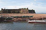 Fort Sta. Isabel
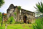 Chapel inside Fort Sta. Isabel
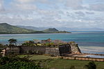 Fortress Sta. Isabel
 Inside the church in the fortress of Santa Isabel
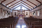 Santa Monica Parish Church
 Night by the sea


References
- Municipality of Taytay | (DILG)
- "2015 Census of Population, Report No. 3 – Population, Land Area, and Population Density" (PDF). Philippine Statistics Authority. Quezon City, Philippines. August 2016. ISSN 0117-1453. Archived (PDF) from the original on May 25, 2021. Retrieved July 16, 2021.
- Census of Population (2020). "MIMAROPA". Total Population by Province, City, Municipality and Barangay. PSA. Retrieved 8 July 2021.
- "PSA Releases the 2018 Municipal and City Level Poverty Estimates". Philippine Statistics Authority. 15 December 2021. Retrieved 22 January 2022.
- Palawan Tourism Council: History of Palawan. Accessed August 27, 2008.
- El Nido Tourism Office. Accessed August 28, 2008.
- Official Website of the Province of Palawan Archived 2008-08-27 at the Wayback Machine. Accessed August 28, 2008.
- "Republic Act No.1748, June 21, 1957". Supreme Court E-Library. Retrieved April 2, 2016.
- "Republic Act No.1238, June 07, 1955". Supreme Court E-Library. Retrieved April 2, 2016.
- "Republic Act No. 1525, June 16, 1956". Supreme Court E-Library. Retrieved April 2, 2016.
- "Republic Act No. 1526, June 16, 1956". Supreme Court E-Library. Retrieved April 2, 2016.
- "Taytay: Average Temperatures and Rainfall". Meteoblue. Retrieved 17 November 2019.
- Census of Population (2015). "Region IV-B (Mimaropa)". Total Population by Province, City, Municipality and Barangay. PSA. Retrieved 20 June 2016.
- Census of Population and Housing (2010). "Region IV-B (Mimaropa)". Total Population by Province, City, Municipality and Barangay. NSO. Retrieved 29 June 2016.
- Censuses of Population (1903–2007). "Region IV-B (Mimaropa)". Table 1. Population Enumerated in Various Censuses by Province/Highly Urbanized City: 1903 to 2007. NSO.
- "Province of Palawan". Municipality Population Data. Local Water Utilities Administration Research Division. Retrieved 17 December 2016.
- "Poverty incidence (PI):". Philippine Statistics Authority. Retrieved 28 December 2020.
- https://psa.gov.ph/sites/default/files/NSCB_LocalPovertyPhilippines_0.pdf; publication date: 29 November 2005; publisher: Philippine Statistics Authority.
- https://psa.gov.ph/sites/default/files/2003%20SAE%20of%20poverty%20%28Full%20Report%29_1.pdf; publication date: 23 March 2009; publisher: Philippine Statistics Authority.
- https://psa.gov.ph/sites/default/files/2006%20and%202009%20City%20and%20Municipal%20Level%20Poverty%20Estimates_0_1.pdf; publication date: 3 August 2012; publisher: Philippine Statistics Authority.
- https://psa.gov.ph/sites/default/files/2012%20Municipal%20and%20City%20Level%20Poverty%20Estima7tes%20Publication%20%281%29.pdf; publication date: 31 May 2016; publisher: Philippine Statistics Authority.
- https://psa.gov.ph/sites/default/files/City%20and%20Municipal-level%20Small%20Area%20Poverty%20Estimates_%202009%2C%202012%20and%202015_0.xlsx; publication date: 10 July 2019; publisher: Philippine Statistics Authority.
- "PSA Releases the 2018 Municipal and City Level Poverty Estimates". Philippine Statistics Authority. 15 December 2021. Retrieved 22 January 2022.
External links
- Taytay Profile at PhilAtlas.com
- Philippine Standard Geographic Code
- Philippine Census Information
- Local Governance Performance Management System
Places adjacent to Taytay, Palawan | ||||||||||||||||
|---|---|---|---|---|---|---|---|---|---|---|---|---|---|---|---|---|
| ||||||||||||||||
Puerto Princesa (capital) | |
| Municipalities | |
| Highly urbanized city |
|
World Heritage Sites in the Philippines | ||
|---|---|---|
| Cultural |
| |
| Natural |
| |
На других языках
[de] Taytay (Palawan)
Taytay ist eine philippinische Stadtgemeinde in der Provinz Palawan. Sie hat 75.165 Einwohner (Zensus 1. August 2015). Sieben Kilometer südöstlich des Gemeindezentrums liegt der Manguao-See, in dem zahlreiche Flüsse münden. Der westliche Teil der Gemeinde liegt im Naturpark Malampaya Sound Protected Landscape/Seascape und der nördliche im El Nido-Taytay Managed Resource Protected Area, beide sind kombinierte Landschafts- und Meeresschutzgebiete.- [en] Taytay, Palawan
Другой контент может иметь иную лицензию. Перед использованием материалов сайта WikiSort.org внимательно изучите правила лицензирования конкретных элементов наполнения сайта.
WikiSort.org - проект по пересортировке и дополнению контента Википедии