world.wikisort.org - Philippines
Sarangani, officially the Municipality of Sarangani (Cebuano: Lungsod sa Sarangani; Tagalog: Bayan ng Sarangani), is a 4th class municipality in the province of Davao Occidental, Philippines. According to the 2020 census, it has a population of 22,515 people. [3]
Sarangani | |
|---|---|
Municipality | |
| Municipality of Sarangani | |
 Seal | |
Nicknames:
| |
| Motto(s): Sarangani Bayan Natin, Sarangani Paraiso Natin! | |
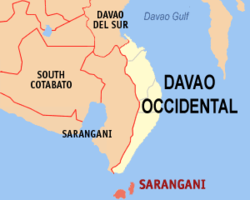 Map of Davao Occidental with Sarangani highlighted | |
OpenStreetMap  | |
 Sarangani Location within the Philippines | |
| Coordinates: 5°24′43″N 125°25′19″E | |
| Country | Philippines |
| Region | Davao Region |
| Province | Davao Occidental |
| District | Lone district |
| Founded | 1980 |
| Barangays | 12 (see Barangays) |
| Government | |
| • Type | Sangguniang Bayan |
| • Mayor | Adelan B. de Arce |
| • Vice Mayor | Marciano C. Lagudas |
| • Representative | Claude P. Bautista |
| • Municipal Council | Members |
| • Electorate | 16,294 voters (2022) |
| Area | |
| • Total | 97.72 km2 (37.73 sq mi) |
| Elevation | 25 m (82 ft) |
| Highest elevation (Mount Balut) | 1,131 m (3,711 ft) |
| Lowest elevation | 0 m (0 ft) |
| Population | |
| • Total | 22,515 |
| • Density | 230/km2 (600/sq mi) |
| • Households | 5,718 |
| Economy | |
| • Income class | 4th municipal income class |
| • Poverty incidence | 35.47% (2018)[4] |
| • Revenue | ₱115,029,859.46 (2020) |
| • Assets | ₱222,668,878.84 (2020) |
| • Expenditure | ₱109,732,644.99 (2020) |
| • Liabilities | ₱64,365,137.98 (2020) |
| Service provider | |
| • Electricity | Davao del Sur Electric Cooperative (DASURECO) |
| Time zone | UTC+8 (PST) |
| ZIP code | 8015 |
| PSGC | |
| IDD : area code | +63 (0)82 |
| Native languages | Davawenyo Cebuano Sarangani Sangirese Tagalog |
| Website | www |
Geography

The municipality consists of 2 major islands (the eponymous Sarangani Island and Balut Island) and 1 minor islet (Olanivan Island), collectively called as the Sarangani Islands, located just south of Mindanao island in the Celebes Sea. It is the municipality of the Philippines bordering Indonesia.[citation needed]
Climate
Sarangani has a tropical rainforest climate (Af) with moderate to heavy rainfall year-round.
| Climate data for Sarangani | |||||||||||||
|---|---|---|---|---|---|---|---|---|---|---|---|---|---|
| Month | Jan | Feb | Mar | Apr | May | Jun | Jul | Aug | Sep | Oct | Nov | Dec | Year |
| Average high °C (°F) | 31.5 (88.7) |
31.8 (89.2) |
32.4 (90.3) |
32.7 (90.9) |
32.0 (89.6) |
31.1 (88.0) |
30.8 (87.4) |
31.1 (88.0) |
31.4 (88.5) |
31.8 (89.2) |
31.9 (89.4) |
31.7 (89.1) |
31.7 (89.0) |
| Daily mean °C (°F) | 26.4 (79.5) |
26.6 (79.9) |
27.1 (80.8) |
27.5 (81.5) |
27.3 (81.1) |
26.6 (79.9) |
26.3 (79.3) |
26.5 (79.7) |
26.7 (80.1) |
27.0 (80.6) |
27.0 (80.6) |
26.8 (80.2) |
26.8 (80.3) |
| Average low °C (°F) | 21.4 (70.5) |
21.5 (70.7) |
21.8 (71.2) |
22.3 (72.1) |
22.6 (72.7) |
22.2 (72.0) |
21.9 (71.4) |
22.0 (71.6) |
22.1 (71.8) |
22.2 (72.0) |
22.1 (71.8) |
21.9 (71.4) |
22.0 (71.6) |
| Average rainfall mm (inches) | 169 (6.7) |
137 (5.4) |
119 (4.7) |
118 (4.6) |
165 (6.5) |
168 (6.6) |
159 (6.3) |
115 (4.5) |
114 (4.5) |
162 (6.4) |
166 (6.5) |
160 (6.3) |
1,752 (69) |
| Source: Climate-Data.org[5] | |||||||||||||
Barangays
Sarangani is politically subdivided into 12 barangays.
- Batuganding
- Konel
- Lipol
- Mabila (Poblacion)
- Tinina
- Gomtago
- Tagen
- Tucal
Sarangani Island
- Patuco (Sarangani Norte) (includes Olanivan islet)
- Laker (Sarangani Sur)
- Camahual
- Camalig
Demographics
| Year | Pop. | ±% p.a. |
|---|---|---|
| 1980 | 11,960 | — |
| 1990 | 15,003 | +2.29% |
| 1995 | 16,648 | +1.97% |
| 2000 | 18,391 | +2.16% |
| 2007 | 20,394 | +1.44% |
| 2010 | 23,290 | +4.95% |
| 2015 | 24,039 | +0.60% |
| 2020 | 22,515 | −1.28% |
| Source: Philippine Statistics Authority [6] [7] [8][9] | ||
Economy
Government
Municipal officials 2013-2016:
- Mayor: Virginia Cawa
- Vice Mayor: Jerry Cawa
- Councilors:
- Alfredo Lora
- Sergio Tablingon
- Adelan de Arce
- Jamere Ismael
- Lorencio Angin
- Windy Grace Gomez
- Jovanie Amierol
- Arturo Olarte, Jr.
References
- Municipality of Sarangani | (DILG)
- "2015 Census of Population, Report No. 3 – Population, Land Area, and Population Density" (PDF). Philippine Statistics Authority. Quezon City, Philippines. August 2016. ISSN 0117-1453. Archived (PDF) from the original on May 25, 2021. Retrieved July 16, 2021.
- Census of Population (2020). "Region XI (Davao Region)". Total Population by Province, City, Municipality and Barangay. PSA. Retrieved 8 July 2021.
- "PSA Releases the 2018 Municipal and City Level Poverty Estimates". Philippine Statistics Authority. 15 December 2021. Retrieved 22 January 2022.
- "Climate: Sarangani". Climate-Data.org. Retrieved 28 October 2020.
- Census of Population (2015). "Region XI (Davao Region)". Total Population by Province, City, Municipality and Barangay. PSA. Retrieved 20 June 2016.
- Census of Population and Housing (2010). "Region XI (Davao Region)". Total Population by Province, City, Municipality and Barangay. NSO. Retrieved 29 June 2016.
- Censuses of Population (1903–2007). "Region XI (Davao Region)". Table 1. Population Enumerated in Various Censuses by Province/Highly Urbanized City: 1903 to 2007. NSO.
- "Province of". Municipality Population Data. Local Water Utilities Administration Research Division. Retrieved 17 December 2016.
- "Poverty incidence (PI):". Philippine Statistics Authority. Retrieved 28 December 2020.
- https://psa.gov.ph/sites/default/files/NSCB_LocalPovertyPhilippines_0.pdf; publication date: 29 November 2005; publisher: Philippine Statistics Authority.
- https://psa.gov.ph/sites/default/files/2003%20SAE%20of%20poverty%20%28Full%20Report%29_1.pdf; publication date: 23 March 2009; publisher: Philippine Statistics Authority.
- https://psa.gov.ph/sites/default/files/2006%20and%202009%20City%20and%20Municipal%20Level%20Poverty%20Estimates_0_1.pdf; publication date: 3 August 2012; publisher: Philippine Statistics Authority.
- https://psa.gov.ph/sites/default/files/2012%20Municipal%20and%20City%20Level%20Poverty%20Estima7tes%20Publication%20%281%29.pdf; publication date: 31 May 2016; publisher: Philippine Statistics Authority.
- https://psa.gov.ph/sites/default/files/City%20and%20Municipal-level%20Small%20Area%20Poverty%20Estimates_%202009%2C%202012%20and%202015_0.xlsx; publication date: 10 July 2019; publisher: Philippine Statistics Authority.
- "PSA Releases the 2018 Municipal and City Level Poverty Estimates". Philippine Statistics Authority. 15 December 2021. Retrieved 22 January 2022.
External links
- Sarangani Profile at the DTI Cities and Municipalities Competitive Index
- Philippine Standard Geographic Code
- Philippine Census Information
- Local Governance Performance Management System
Places adjacent to Sarangani, Davao Occidental | ||||||||||||||||
|---|---|---|---|---|---|---|---|---|---|---|---|---|---|---|---|---|
| ||||||||||||||||
Malita (capital) | |
| Municipalities | |
Authority control | |
|---|---|
| General | |
| National libraries | |
This article about a location in Davao Region is a stub. You can help Wikipedia by expanding it. |
На других языках
[de] Sarangani (Davao Occidental)
Sarangani ist eine philippinische Stadtgemeinde in der Provinz Davao Occidental. Sie hat 24.039 Einwohner (Zensus 1. August 2015). Die Gemeinde liegt auf den Inseln Balut und Sarangani, auf der Insel Balut erhebt sich der 862 Meter hohe Vulkan Balut.- [en] Sarangani, Davao Occidental
Другой контент может иметь иную лицензию. Перед использованием материалов сайта WikiSort.org внимательно изучите правила лицензирования конкретных элементов наполнения сайта.
WikiSort.org - проект по пересортировке и дополнению контента Википедии