world.wikisort.org - Philippines
Banaue (or alternatively spelled as Banawe), officially the Municipality of Banaue is a 4th class municipality in the province of Ifugao, Philippines. According to the 2020 census, it has a population of 20,652 people. [3]
Banaue | |
|---|---|
Municipality | |
| Municipality of Banaue | |
 Town of Banaue | |
 Flag | |
 Map of Ifugao with Banaue highlighted | |
OpenStreetMap  | |
 Banaue Location within the Philippines | |
| Coordinates: 16°54′43″N 121°03′41″E | |
| Country | Philippines |
| Region | Cordillera Administrative Region |
| Province | Ifugao |
| District | Lone district |
| Barangays | 18 (see Barangays) |
| Government | |
| • Type | Sangguniang Bayan |
| • Mayor | Joel B. Bungallon |
| • Vice Mayor | Donald L. Mongolnon |
| • Representative | Solomon R. Chungalao |
| • Municipal Council | Members |
| • Electorate | 14,892 voters (2022) |
| Area | |
| • Total | 191.20 km2 (73.82 sq mi) |
| Elevation | 1,303 m (4,275 ft) |
| Highest elevation | 2,689 m (8,822 ft) |
| Lowest elevation | 481 m (1,578 ft) |
| Population | |
| • Total | 20,652 |
| • Density | 110/km2 (280/sq mi) |
| • Households | 4,306 |
| Economy | |
| • Income class | 4th municipal income class |
| • Poverty incidence | 19.22% (2018)[4] |
| • Revenue | ₱129,795,879.28 (2020) |
| • Assets | ₱452,342,902.29 (2020) |
| • Expenditure | ₱104,648,957.70 (2020) |
| • Liabilities | ₱234,129,338.77 (2020) |
| Service provider | |
| • Electricity | Ifugao Electric Cooperative (IFELCO) |
| Time zone | UTC+8 (PST) |
| ZIP code | 3601 |
| PSGC | |
| IDD : area code | +63 (0)74 |
| Native languages | Ifugao Tuwali Ilocano Tagalog |
| Website | www |
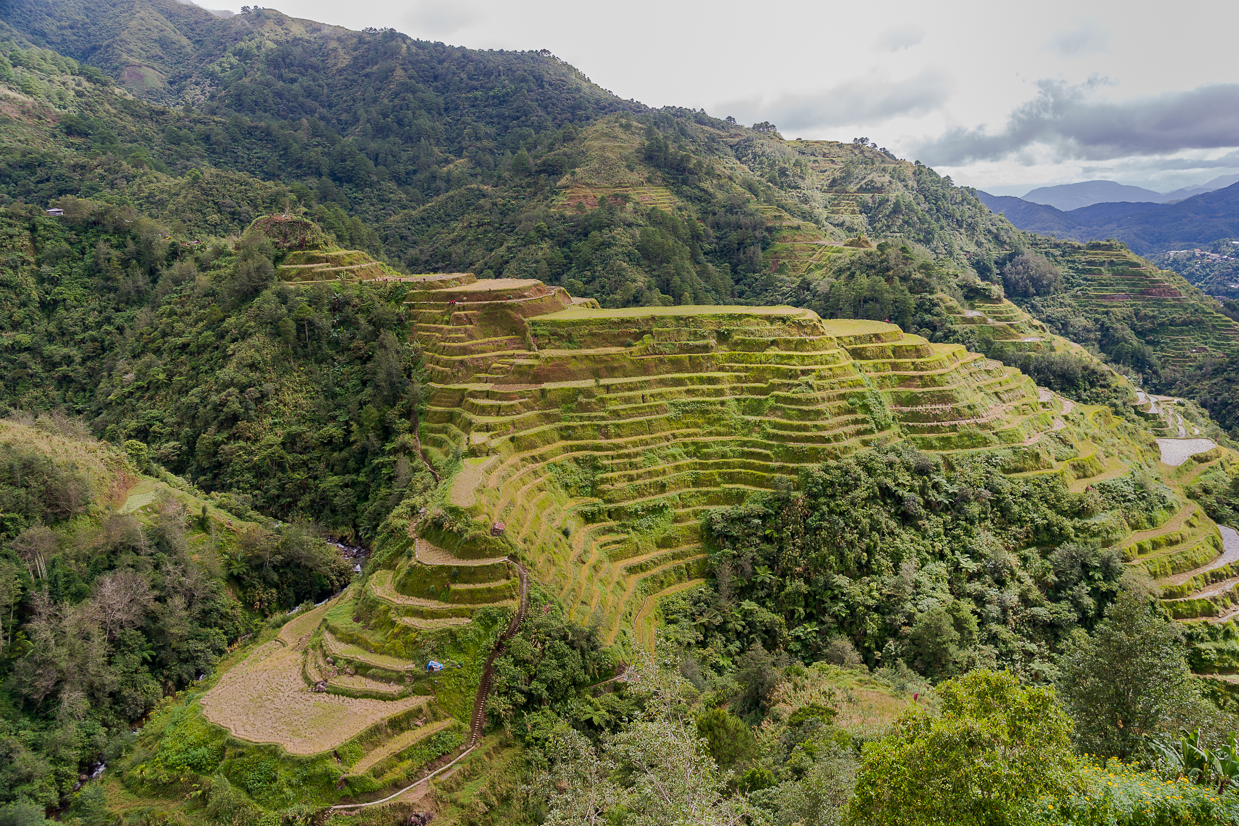
It is widely known as the site of the UNESCO World Heritage Site, the Batad Rice Terraces and Bangaan Rice Terraces.
Banaue is 24 kilometres (15 mi) from Lagawe and 341 kilometres (212 mi) from Manila.
History
This section is empty. You can help by adding to it. (January 2022) |
Geography
Barangays
Banaue is politically subdivided into 18 barangays. [5] These barangays are headed by elected officials: Barangay Captain, Barangay Council, whose members are called Barangay Councilors. All are elected every three years.
- Amganad
- Anaba
- Balawis
- Bangaan
- Batad
- Bocos
- Banao
- Cambulo
- Ducligan
- Gohang
- Kinakin
- Uhaj
- Poblacion
- Poitan
- Pula
- San Fernando
- Tam-an
- View Point
Climate
| Climate data for Banaue, Ifugao | |||||||||||||
|---|---|---|---|---|---|---|---|---|---|---|---|---|---|
| Month | Jan | Feb | Mar | Apr | May | Jun | Jul | Aug | Sep | Oct | Nov | Dec | Year |
| Average high °C (°F) | 21 (70) |
23 (73) |
24 (75) |
26 (79) |
25 (77) |
25 (77) |
24 (75) |
24 (75) |
24 (75) |
24 (75) |
23 (73) |
22 (72) |
24 (75) |
| Average low °C (°F) | 15 (59) |
15 (59) |
16 (61) |
18 (64) |
19 (66) |
19 (66) |
19 (66) |
19 (66) |
19 (66) |
18 (64) |
17 (63) |
16 (61) |
18 (63) |
| Average precipitation mm (inches) | 35 (1.4) |
46 (1.8) |
63 (2.5) |
117 (4.6) |
402 (15.8) |
400 (15.7) |
441 (17.4) |
471 (18.5) |
440 (17.3) |
258 (10.2) |
94 (3.7) |
68 (2.7) |
2,835 (111.6) |
| Average rainy days | 9.9 | 11.1 | 13.9 | 18.9 | 26.0 | 27.3 | 28.9 | 28.5 | 26.1 | 19.7 | 14.5 | 12.8 | 237.6 |
| Source: Meteoblue[6] | |||||||||||||
Demographics
| Year | Pop. | ±% p.a. |
|---|---|---|
| 1918 | 17,013 | — |
| 1939 | 17,127 | +0.03% |
| 1948 | 15,311 | −1.24% |
| 1960 | 17,877 | +1.30% |
| 1970 | 20,268 | +1.26% |
| 1975 | 20,489 | +0.22% |
| 1980 | 22,900 | +2.25% |
| 1990 | 16,943 | −2.97% |
| 1995 | 20,514 | +3.65% |
| 2000 | 20,563 | +0.05% |
| 2007 | 21,448 | +0.58% |
| 2010 | 22,365 | +1.54% |
| 2015 | 21,837 | −0.45% |
| 2020 | 20,652 | −1.09% |
| Source: Philippine Statistics Authority [7] [8] [9][10] | ||
In the 2020 census, the population of Banaue was 20,652 people, [3] with a density of 110 inhabitants per square kilometre or 280 inhabitants per square mile.
Economy
Government
Banaue, belonging to the lone congressional district of the province of Ifugao, is governed by a mayor designated as its local chief executive and by a municipal council as its legislative body in accordance with the Local Government Code. The mayor, vice mayor, and the councilors are elected directly by the people through an election which is being held every three years.
Elected officials
| Position | Name |
|---|---|
| Congressman | Solomon R. Chungalao |
| Mayor | John Raymund Wesley A. Dulawan |
| Vice-Mayor | Donald L. Mongolnon |
| Councilors | John Alfred D. Cappleman II |
| Roberto M. Immotna | |
| Albert B. Magguling Sr. | |
| Lino A. Madchiw | |
| Chester D. Bahatan | |
| Fermin P. Haclao Jr. | |
| Abelardo B. Batton | |
| Fernando B. Chulipa | |
Ifugao Rice Terraces
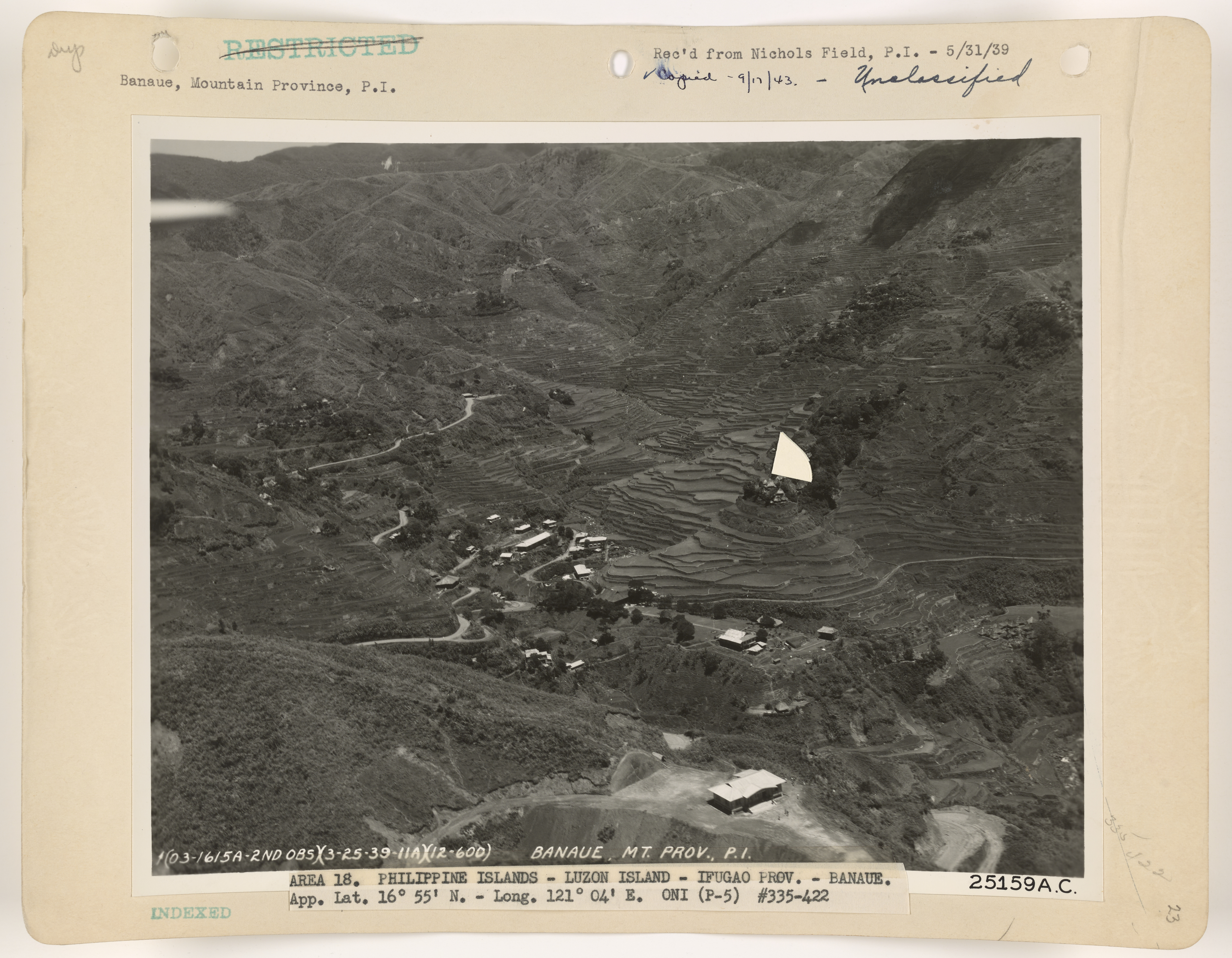
Sometimes called by locals as the "Eighth Wonder of the World", the Ifugao Rice Terraces begin at the base of the mountain range and extend several thousand feet upwards. Two of the terrace clusters in Banaue, namely Bangaan and Batad, are part of the UNESCO World Heritage inscription. It is said that their length, if put end to end, would encircle half of the globe. The terraces are believed by many to be more than 2,000 years old as postulated by early Philippine anthropologist Otley Beyer, recent studies by carbon dating however contends this and instead the structures may be less than 1,000 years old.[19][20] The rice terraces manifest the engineering skill and ingenuity of the sturdy Ifugaos. They are irrigated by means of mountain streams and springs that have been tapped and channelled into canals that run downhill through the rice terraces.


The rice terraces once stretched north-east to Cagayan and as far south as Quezon. However they are now slowly being abandoned and showing signs of deterioration. The 1990 Luzon earthquake damaged some of the terraces' irrigation systems, while El Niño triggered droughts that led giant earthworms to erode the terraces' soil. Furthermore, the rice variety most suited to the area's cool climate is not a high-yielding crop; because it takes so long to mature, some Ifugao families have abandoned their land in the rice terraces in favour of land that reaps faster rewards.
An Ifugao Terraces Commission was created in 1994 and was superseded by the Banaue Rice Terraces task force, which was closed in 2002.
UNESCO has listed the Batad Rice Terraces and Bangaan Rice Terraces as a World Heritage Site since 1995, under the designation, Rice Terraces of the Philippine Cordilleras.[21]
All located in the Ifugao region, the Rice Terraces also feature as one of the Globally Important Agricultural Heritage Systems or GIAHS. They are supported by indigenous knowledge management of muyong, a private forest that caps each terrace cluster. The muyong is managed through a collective effort and under traditional tribal practices. The communally managed forestry area on top of the terraces contains about 264 indigenous plant species, mostly endemic to the region. The terraces form unique clusters of microwatersheds and are part of the whole mountain ecology. They serve as a rainwater filtration system and are saturated with irrigation water all year round. A biorhythm technology, in which cultural activities are harmonised with the rhythm of climate and hydrology management, has enabled farmers to grow rice at over 1 000 metres.
Contrary to popular notion, the Banaue Rice Terraces as seen from the viewpoint[where?] are not included in the UNESCO inscription, due to the presence of numerous modern structures. However, it is a National Cultural Treasure under the Ifugao Rice Terraces.
The Banaue Rice Terraces were chosen as one of the two green globe destinations of the country by the World Travel and Tour Council. It received an “International Historic Engineering Landmark Award” from the American Society of Civil Engineers. It was also acknowledged by the World Travel and Tour Council as a green globe destination in the Philippines.[22]
The stone walled rice terraces were built by means of early tools and methods in order to maximise the use of land space, They exceed the height of the world's tallest building if the vertical distance between top and bottom row are measured.[22]
See also
- Banaue Rice Terraces
References
- Municipality of Banaue | (DILG)
- "2015 Census of Population, Report No. 3 – Population, Land Area, and Population Density" (PDF). Philippine Statistics Authority. Quezon City, Philippines. August 2016. ISSN 0117-1453. Archived (PDF) from the original on May 25, 2021. Retrieved July 16, 2021.
- Census of Population (2020). "Cordillera Administrative Region (CAR)". Total Population by Province, City, Municipality and Barangay. PSA. Retrieved 8 July 2021.
- "PSA Releases the 2018 Municipal and City Level Poverty Estimates". Philippine Statistics Authority. 15 December 2021. Retrieved 22 January 2022.
- "Province: Ifugao". PSGC Interactive. Quezon City, Philippines: Philippine Statistics Authority. Retrieved 12 November 2016.
- "Banaue: Average Temperatures and Rainfall". Meteoblue. Retrieved 8 March 2020.
- Census of Population (2015). "Cordillera Administrative Region (CAR)". Total Population by Province, City, Municipality and Barangay. PSA. Retrieved 20 June 2016.
- Census of Population and Housing (2010). "Cordillera Administrative Region (CAR)". Total Population by Province, City, Municipality and Barangay. NSO. Retrieved 29 June 2016.
- Censuses of Population (1903–2007). "Cordillera Administrative Region (CAR)". Table 1. Population Enumerated in Various Censuses by Province/Highly Urbanized City: 1903 to 2007. NSO.
- "Province of Ifugao". Municipality Population Data. Local Water Utilities Administration Research Division. Retrieved 17 December 2016.
- "Poverty incidence (PI):". Philippine Statistics Authority. Retrieved 28 December 2020.
- https://psa.gov.ph/sites/default/files/NSCB_LocalPovertyPhilippines_0.pdf; publication date: 29 November 2005; publisher: Philippine Statistics Authority.
- https://psa.gov.ph/sites/default/files/2003%20SAE%20of%20poverty%20%28Full%20Report%29_1.pdf; publication date: 23 March 2009; publisher: Philippine Statistics Authority.
- https://psa.gov.ph/sites/default/files/2006%20and%202009%20City%20and%20Municipal%20Level%20Poverty%20Estimates_0_1.pdf; publication date: 3 August 2012; publisher: Philippine Statistics Authority.
- https://psa.gov.ph/sites/default/files/2012%20Municipal%20and%20City%20Level%20Poverty%20Estima7tes%20Publication%20%281%29.pdf; publication date: 31 May 2016; publisher: Philippine Statistics Authority.
- https://psa.gov.ph/sites/default/files/City%20and%20Municipal-level%20Small%20Area%20Poverty%20Estimates_%202009%2C%202012%20and%202015_0.xlsx; publication date: 10 July 2019; publisher: Philippine Statistics Authority.
- "PSA Releases the 2018 Municipal and City Level Poverty Estimates". Philippine Statistics Authority. 15 December 2021. Retrieved 22 January 2022.
- "2019 National and Local Elections" (PDF). Commission on Elections. Retrieved March 13, 2022.
{{cite web}}: CS1 maint: url-status (link) - Cabreza, Vincent (July 15, 2013). "For Ifugao rice terraces, age should not matter". Philippine Daily Inquirer. Retrieved 29 January 2018.
- "Ifugao Rice Terraces may be younger than we think". Rappler. April 29, 2015. Retrieved 29 January 2018.
- Rice Terraces of the Philippine Cordilleras, UNESCO World Heritage Site.
- Banaue, e-philippines.
External links
- Official website
- Philippine Standard Geographic Code
- Philippine Census Information
- Local Governance Performance Management System
Places adjacent to Banaue | ||||||||||||||||
|---|---|---|---|---|---|---|---|---|---|---|---|---|---|---|---|---|
| ||||||||||||||||
Lagawe (capital) | |
| Municipalities | |
| Barangays | See: List of barangays in Ifugao |
Authority control | |
|---|---|
| General |
|
| National libraries | |
На других языках
[de] Banaue
Banaue (offiziell: Municipality of Banaue; Filipino: Bayan ng Banaue; Ilocano: Illi ti Banaue) ist eine philippinische Stadtgemeinde in der Provinz Ifugao. Banaue liegt im Norden der Insel Luzon in den philippinischen Zentralkordilleren. Das Gebiet ist gebirgig, der höchste Berg ist der Mt. Amuyao mit einer Höhe von 2628 m über dem Meer. Auf dem Gebiet der Stadtgemeinde Banaue liegt das UNESCO-Weltkulturerbe Reisterrassen von Banaue.- [en] Banaue
Другой контент может иметь иную лицензию. Перед использованием материалов сайта WikiSort.org внимательно изучите правила лицензирования конкретных элементов наполнения сайта.
WikiSort.org - проект по пересортировке и дополнению контента Википедии