world.wikisort.org - Peru
Layo District is one of eight districts in the Canas Province in Peru. The seat of the Layo District is the village Layo.
Layo
Layu | |
|---|---|
District | |
 The train the Belmond Andean Explorer[2] at La Raya Station with market stalls and the mountain Chimpulla in the background, Layo District-Santa Rosa District | |
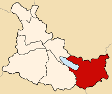 Location of Layo in the Canas province | |
| Country | |
| Region | Cusco |
| Province | Canas |
| Founded | January 2, 1857 |
| Capital | Layo |
| Government | |
| • Mayor | Daniel Praxides Quispe Alanocca (2007) |
| Area | |
| • Total | 452.56 km2 (174.73 sq mi) |
| Elevation | 3,978 m (13,051 ft) |
| Population (2005 census) | |
| • Total | 6,822 |
| • Density | 15/km2 (39/sq mi) |
| Time zone | UTC-5 (PET) |
| UBIGEO | 080505 |
Geography
The La Raya mountain range traverses the district. Some of the highest mountains of the district are listed below:[3]
- Anta
- Anta Pata
- Aqu Muqu
- Chayña Tira
- Chawpi Tira
- Chimpulla
- Ch'ulluni
- Hatun Ichhuna Kunka
- Huch'uy K'uchu
- Jichu Qullu
- Kancha
- Kimsa Urqu
- Kiswarani
- Kunka
- Kuntur Sallana
- Laramani
- Pawka
- Pichaqani
- Pinqulluni
- Puka Puka
- Puka Urqu
- Pukara
- Phawsi Urqu
- Qayqu
- Q'atawi
- Sapan Warmi
- Saywani
- Suntur Qullu
- Sura Quta
- Tika Pallana
- Waylla Kunka
- Yana Ranra
Ethnic groups
The people in the district are mainly indigenous citizens of Quechua descent. Quechua is the language which the majority of the population (90.47%) learnt to speak in childhood, 9.39% of the residents started speaking using the Spanish language (2007 Peru Census).[4]
Sources
- Belmont
- Belmont
- escale.minedu.gob.pe - UGEL map of the Melgar Province (Puno Region)
- inei.gob.pe Archived 2013-01-27 at the Wayback Machine INEI, Peru, Censos Nacionales 2007, Frequencias: Preguntas de Población
| |
|---|---|
| Acomayo | |
| Anta | |
| Calca | |
| Canas |
|
| Canchis | |
| Chumbivilcas | |
| Cusco | |
| Espinar |
|
| La Convención |
|
| Paruro | |
| Paucartambo |
|
| Quispicanchi | |
| Urubamba |
|
This Cusco Region geography article is a stub. You can help Wikipedia by expanding it. |
На других языках
[de] Distrikt Layo
Der Distrikt Layo liegt in der Provinz Canas in der Region Cusco in Südzentral-Peru. Der Distrikt wurde am 2. Januar 1857 gegründet. Er hat eine Fläche von 452,56 km². Beim Zensus 2017 wurden 5171 Einwohner gezählt. Im Jahr 1993 lag die Einwohnerzahl bei 3399, im Jahr 2007 bei 2965. Sitz der Distriktverwaltung ist die auf einer Höhe von 3978 m gelegenen Ortschaft Layo mit 671 Einwohnern (Stand 2017). Layo liegt 45 km südsüdöstlich der Provinzhauptstadt Yanaoca am Ostufer des Sees Laguna Langui Layo.- [en] Layo District
Текст в блоке "Читать" взят с сайта "Википедия" и доступен по лицензии Creative Commons Attribution-ShareAlike; в отдельных случаях могут действовать дополнительные условия.
Другой контент может иметь иную лицензию. Перед использованием материалов сайта WikiSort.org внимательно изучите правила лицензирования конкретных элементов наполнения сайта.
Другой контент может иметь иную лицензию. Перед использованием материалов сайта WikiSort.org внимательно изучите правила лицензирования конкретных элементов наполнения сайта.
2019-2026
WikiSort.org - проект по пересортировке и дополнению контента Википедии
WikiSort.org - проект по пересортировке и дополнению контента Википедии