world.wikisort.org - Norway
Stod is a former municipality in the old Nord-Trøndelag county in Norway. The 275-square-kilometre (106 sq mi) municipality existed from 1838 until 1964. It originally encompassed the northern part of what is now the municipality of Steinkjer, stretching from the town of Steinkjer to the northeast, along the lake Snåsavatnet, to the municipal border with Snåsa. Over time, however, the municipality was reduced in size to just a fraction of its original size, leaving just the area between the Snåsavatnet in the north to the Ogndalen valley in the south. The administrative centre of the municipality was the village of Binde. The main church for Stod was For Church, located just south of the administrative center. The local sports team is Stod IL.[2]

Stod herad | |
|---|---|
Former municipality | |
 Nord-Trøndelag within Norway | |
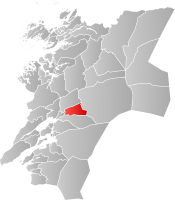 Stod within Nord-Trøndelag | |
| Coordinates: 64°04′16″N 11°40′05″E | |
| Country | Norway |
| County | Nord-Trøndelag |
| District | Innherred |
| Established | 1 Jan 1838 |
| • Created as | Formannskapsdistrikt |
| Disestablished | 1 Jan 1964 |
| • Succeeded by | Steinkjer Municipality |
| Administrative centre | Binde |
| Area (upon dissolution) | |
| • Total | 275 km2 (106 sq mi) |
| Population (1964) | |
| • Total | 1,268 |
| • Density | 4.6/km2 (12/sq mi) |
| Demonym(s) | Stodbygg[1] |
| Time zone | UTC+01:00 (CET) |
| • Summer (DST) | UTC+02:00 (CEST) |
| ISO 3166 code | NO-1734 |
Stod is best known for rock carvings in the Bølareinen field that are approximately 6000 years old. The carvings are of animals and humans. There are several other prehistoric sites, including two stone circles, one on the Nordgård farm and one at the rectory, both of which are partially destroyed.
Traditionally, agriculture and forestry were the major industries in Stod, but construction of the Nordlandsbanen railway line brought with it new jobs and a dairy. Today most residents of Stod work in the town of Steinkjer.[3]
History
The parish of Stod was established as a municipality on 1 January 1838 (see formannskapsdistrikt). On 23 January 1858, the growing village of Steinkjer was established as a kjøpstad (town) with a population of 1,150. The new town was separated from the municipality of Stod to constitute its own municipality leaving Stod with 3,471 residents.
On 1 January 1869, the western district of Egge (population: 941) was separated from Stod to form its own municipality. This left Stod with 2,530 inhabitants. On 1 January 1909, the northern district of Kvam (population: 1,169) became a separate municipality, leaving Stod with 934 inhabitants.
During the 1960s, there were many municipal mergers across Norway due to the work of the Schei Committee. On 1 January 1964, a large merger took place: the neighboring municipalities of Beitstad (population: 2,563), Egge (population: 3,476), Kvam (population: 1,245), Ogndal (population: 2,678), Sparbu (population: 4,027), and Stod (population: 1,268) were all merged with the town of Steinkjer (population: 4,325) to form the new municipality of Steinkjer.[4]
Government
All municipalities in Norway, including Stod, are responsible for primary education (through 10th grade), outpatient health services, senior citizen services, unemployment and other social services, zoning, economic development, and municipal roads. The municipality is governed by a municipal council of elected representatives, which in turn elects a mayor.[5]
Municipal council
The municipal council (Herredsstyre) of Stod was made up of 13 representatives that were elected to four year terms. The party breakdown of the final municipal council was as follows:
| Party Name (in Norwegian) | Number of representatives | |
|---|---|---|
| Labour Party (Arbeiderpartiet) | 5 | |
| Centre Party (Senterpartiet) | 6 | |
| Liberal Party (Venstre) | 2 | |
| Total number of members: | 13 | |
| Party Name (in Norwegian) | Number of representatives | |
|---|---|---|
| Labour Party (Arbeiderpartiet) | 5 | |
| Farmers' Party (Bondepartiet) | 5 | |
| Liberal Party (Venstre) | 3 | |
| Total number of members: | 13 | |
| Party Name (in Norwegian) | Number of representatives | |
|---|---|---|
| Labour Party (Arbeiderpartiet) | 5 | |
| Farmers' Party (Bondepartiet) | 4 | |
| Liberal Party (Venstre) | 3 | |
| Total number of members: | 12 | |
| Party Name (in Norwegian) | Number of representatives | |
|---|---|---|
| Labour Party (Arbeiderpartiet) | 5 | |
| Farmers' Party (Bondepartiet) | 4 | |
| Liberal Party (Venstre) | 3 | |
| Total number of members: | 12 | |
| Party Name (in Norwegian) | Number of representatives | |
|---|---|---|
| Labour Party (Arbeiderpartiet) | 5 | |
| Joint List(s) of Non-Socialist Parties (Borgerlige Felleslister) | 7 | |
| Total number of members: | 12 | |
| Party Name (in Norwegian) | Number of representatives | |
|---|---|---|
| Labour Party (Arbeiderpartiet) | 5 | |
| Joint List(s) of Non-Socialist Parties (Borgerlige Felleslister) | 7 | |
| Total number of members: | 12 | |
| Note: Due to the German occupation of Norway during World War II, no elections were held for new municipal councils until after the war ended in 1945. | ||
Mayors
There were 28 different men that were elected to the office of mayor of Stod from 1838 until 1964.[12]
- Peder Rasmus Lyng (1838–1843)
- Thomas Balchen (1844–1845)
- Martin Hannestad (1846–1847)
- Jonas Haugum (1848–1851)
- Ole O. Rygg (1852–1855)
- Peter Taraldsen (1856–1859)
- Ole Lægran (1860–1861)
- Jakob Haugum (1862–1867)
- Ole Anton Qvam (1868–1869)
- Adolf Bødtker (1870–1877)
- Chr. Elden (1878–1881)
- Henrik Østgård (1882–1883)
- P. Følling (1884–1889)
- E.A. Næstvold (1890–1891)
- O.K. Forfang (1892–1895)
- P. Følling (1896–1907)
- Arne Vollan (1908–1910)
- Andreas Lillevestre (1911–1919)
- John Tiltnes (1920–1922)
- Albert Eggen (1923–1925)
- Sverre Andreassen Lillevestre (1926–1928)
- Olaf Hatling (1929–1931)
- Sverre Andreassen Lillevestre (1932–1934)
- Kaspar Flekstad (1935–1937)
- Albert Eggen (1938–1940)
- Georg Høin (1941–1942)
- Nikolai Valøen (1943–1945)
- Sverre Binde (1946–1947)
- Olav Molberg (1948–1951)
- Einar Ystgård (1952–1955)
- Olav Molberg (1956–1959)
- Alf Hatling (1960–1963)
See also
- List of former municipalities of Norway
References
- "Navn på steder og personer: Innbyggjarnamn" (in Norwegian). Språkrådet.
- Rosvold, Knut A., ed. (2018-02-05). "Stod". Store norske leksikon (in Norwegian). Kunnskapsforlaget. Retrieved 2018-04-08.
- Steinkjerleksikonet. "Stod kommune" (in Norwegian). Retrieved 2011-07-16.
- Jukvam, Dag (1999). "Historisk oversikt over endringer i kommune- og fylkesinndelingen" (PDF) (in Norwegian). Statistisk sentralbyrå.
- Hansen, Tore, ed. (2016-05-12). "kommunestyre". Store norske leksikon (in Norwegian). Kunnskapsforlaget. Retrieved 2020-02-02.
- "Kommunevalgene og Ordførervalgene 1959" (PDF) (in Norwegian). Oslo: Statistisk sentralbyrå. 1960. Retrieved 2020-04-14.
- "Kommunevalgene og Ordførervalgene 1955" (PDF) (in Norwegian). Oslo: Statistisk sentralbyrå. 1957. Retrieved 2020-04-14.
- "Kommunevalgene og Ordførervalgene 1951" (PDF) (in Norwegian). Oslo: Statistisk sentralbyrå. 1952. Retrieved 2020-04-14.
- "Kommunevalgene og Ordførervalgene 1947" (PDF) (in Norwegian). Oslo: Statistisk sentralbyrå. 1948. Retrieved 2020-04-14.
- "Kommunevalgene og Ordførervalgene 1945" (PDF) (in Norwegian). Oslo: Statistisk sentralbyrå. 1947. Retrieved 2020-04-14.
- "Kommunevalgene og Ordførervalgene 1937" (PDF) (in Norwegian). Oslo: Statistisk sentralbyrå. 1938. Retrieved 2020-04-14.
- "Ordførere i Stod kommune" [Mayors of Stod municipality] (in Norwegian). Steinkjer Leksikonet. Retrieved 2018-04-08.
Trøndelag county, Norway | |||||||||||
|---|---|---|---|---|---|---|---|---|---|---|---|
| |||||||||||
 | Towns and cities |
|  | ||||||||
| Municipalities |
| ||||||||||
| Authority control |
|
|---|
Другой контент может иметь иную лицензию. Перед использованием материалов сайта WikiSort.org внимательно изучите правила лицензирования конкретных элементов наполнения сайта.
WikiSort.org - проект по пересортировке и дополнению контента Википедии