world.wikisort.org - Norway
Landvik is a former municipality in the old Aust-Agder county in Norway. The 190.7-square-kilometre (73.6 sq mi) municipality existed from 1838 until its dissolution in 1971. The municipality's area is now located in the western and central part of the present-day municipality of Grimstad. The administrative centre was the village of Roresanden, just up the hill from the Landvik Church. Other villages in Landvik include Molland, Reddal, Skiftenes, Tjore, and Østerhus. Today, the name Landvik is still used to designate the westernmost part of the municipality of Grimstad, near the Prestegårdskogen housing development.[1][2]
Landvik kommune
Hommedal herred | |
|---|---|
Former municipality | |
 View of the local church | |
 Aust-Agder within Norway | |
 Landvik within Aust-Agder | |
| Coordinates: 58°20′24″N 08°31′13″E | |
| Country | Norway |
| County | Aust-Agder |
| District | Østre Agder |
| Established | 1 Jan 1838 |
| • Created as | Formannskapsdistrikt |
| Disestablished | 1 Jan 1971 |
| • Succeeded by | Grimstad Municipality |
| Administrative centre | Roresanden |
| Area (upon dissolution)[1] | |
| • Total | 190.7 km2 (73.6 sq mi) |
| Population (1971) | |
| • Total | 2,781 |
| • Density | 15/km2 (38/sq mi) |
| Time zone | UTC+01:00 (CET) |
| • Summer (DST) | UTC+02:00 (CEST) |
| ISO 3166 code | NO-0924 |
History
The parish of Hommedal was established as a municipality on 1 January 1838 (see formannskapsdistrikt law). In 1865, the municipality was renamed Landvig. Originally, the municipal council met at the Torp farm in Reddal. Starting in the 1840s, the council met at the Landvik farm near the church. In 1876, the council began meeting at the Vikmarken school, just south of Roresanden. On 1 January 1883, the uninhabited Tolleholmen part of neighboring Birkenes municipality was transferred to Landvik. In 1956, the municipal council began meeting at the Landvik herredshus in Roresanden.[2][3]
During the 1960s, there were many municipal mergers across Norway due to the work of the Schei Committee. On 1 January 1962, the uninhabited area of Salvestjønn in neighboring Øyestad municipality and most of the municipality of Eide (504 inhabitants) were merged into the municipality of Landvik. After the merger, Landvik had a total of 2,433 residents.
Then on 1 January 1971, the neighboring municipalities of Landvik and Fjære were merged with the town of Grimstad to create a new, larger municipality of Grimstad. Prior to the merger, Landvik had a population of 2,781.[4]
Name
The municipality (and parish) is named after the old Landvig farm since that is where the local church was located. The first element of the name means "land" (Old Norse: Land) and the last element (Old Norse: Vík) is identical with the modern Norwegian word vik which means "inlet". The farm is located on a bay on the northeast side of the Landvikvannet lake.[5] From 1838 until 1865, the municipality was named Hommedal. In 1865, it was changed to Landvig, and in the 20th century the spelling was adjusted to Landvik.
Government
All municipalities in Norway, including Landvik, are responsible for primary education (through 10th grade), outpatient health services, senior citizen services, unemployment and other social services, zoning, economic development, and municipal roads. The municipality was governed by a municipal council of elected representatives, which in turn elected a mayor.[6]
Municipal council
The municipal council (Kommunestyre) of Landvik was made up of representatives that were elected to four year terms. The party breakdown of the final municipal council was as follows:
| Party Name (in Norwegian) | Number of representatives | |
|---|---|---|
| Labour Party (Arbeiderpartiet) | 6 | |
| Conservative Party (Høyre) | 3 | |
| Christian Democratic Party (Kristelig Folkeparti) | 2 | |
| Centre Party (Senterpartiet) | 7 | |
| Liberal Party (Venstre) | 3 | |
| Total number of members: | 21 | |
| Party Name (in Norwegian) | Number of representatives | |
|---|---|---|
| Labour Party (Arbeiderpartiet) | 6 | |
| Conservative Party (Høyre) | 4 | |
| Christian Democratic Party (Kristelig Folkeparti) | 2 | |
| Centre Party (Senterpartiet) | 6 | |
| Liberal Party (Venstre) | 3 | |
| Total number of members: | 21 | |
| Party Name (in Norwegian) | Number of representatives | |
|---|---|---|
| Labour Party (Arbeiderpartiet) | 4 | |
| Conservative Party (Høyre) | 2 | |
| Christian Democratic Party (Kristelig Folkeparti) | 2 | |
| Centre Party (Senterpartiet) | 6 | |
| Liberal Party (Venstre) | 3 | |
| Total number of members: | 17 | |
| Party Name (in Norwegian) | Number of representatives | |
|---|---|---|
| Labour Party (Arbeiderpartiet) | 4 | |
| Conservative Party (Høyre) | 2 | |
| Christian Democratic Party (Kristelig Folkeparti) | 2 | |
| Farmers' Party (Bondepartiet) | 6 | |
| Liberal Party (Venstre) | 3 | |
| Total number of members: | 17 | |
| Party Name (in Norwegian) | Number of representatives | |
|---|---|---|
| Labour Party (Arbeiderpartiet) | 5 | |
| Conservative Party (Høyre) | 2 | |
| Farmers' Party (Bondepartiet) | 5 | |
| Liberal Party (Venstre) | 4 | |
| Total number of members: | 16 | |
| Party Name (in Norwegian) | Number of representatives | |
|---|---|---|
| Labour Party (Arbeiderpartiet) | 5 | |
| Conservative Party (Høyre) | 2 | |
| Farmers' Party (Bondepartiet) | 4 | |
| Joint list of the Liberal Party (Venstre) and the Radical People's Party (Radikale Folkepartiet) | 5 | |
| Total number of members: | 16 | |
| Party Name (in Norwegian) | Number of representatives | |
|---|---|---|
| Labour Party (Arbeiderpartiet) | 5 | |
| Conservative Party (Høyre) | 2 | |
| Farmers' Party (Bondepartiet) | 5 | |
| Joint list of the Liberal Party (Venstre) and the Radical People's Party (Radikale Folkepartiet) | 4 | |
| Total number of members: | 16 | |
| Party Name (in Norwegian) | Number of representatives | |
|---|---|---|
| Labour Party (Arbeiderpartiet) | 3 | |
| Conservative Party (Høyre) | 4 | |
| Farmers' Party (Bondepartiet) | 4 | |
| Liberal Party (Venstre) | 5 | |
| Total number of members: | 16 | |
| Note: Due to the German occupation of Norway during World War II, no elections were held for new municipal councils until after the war ended in 1945. | ||
Maps
 Map of Landvik prior to 1962 (also showing Eide and Fjære municipalities and the town of Grimstad)
 Map of the area of Birkenes that was transferred to Landvik in 1883
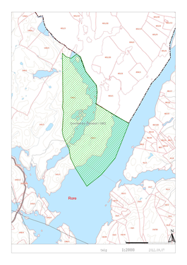 Map of the Salveskjenn area of Øyestad that was transferred to Landvik in 1962


See also
- List of former municipalities of Norway
References
- Kiær, Anders Nicolai; Helland, Amund; Vibe, Johan; Strøm, Boye (1904). "Landvig herred". Norges land og folk: Nedenes amt (in Norwegian). Norway: H. Aschehoug & Company. p. 348. Retrieved 7 November 2017.
- Thorsnæs, Geir, ed. (19 July 2015). "Landvik – tidligere kommune". Store norske leksikon (in Norwegian). Kunnskapsforlaget. Retrieved 7 November 2017.
- "Grimstad rådhus" (in Norwegian). Grimstad kommune. Retrieved 7 November 2017.
- Jukvam, Dag (1999). "Historisk oversikt over endringer i kommune- og fylkesinndelingen" (PDF) (in Norwegian). Statistisk sentralbyrå.
- Rygh, Oluf (1905). Norske gaardnavne: Nedenes amt (in Norwegian) (8 ed.). Kristiania, Norge: W. C. Fabritius & sønners bogtrikkeri. p. 128.
- Hansen, Tore, ed. (12 May 2016). "kommunestyre". Store norske leksikon (in Norwegian). Kunnskapsforlaget. Retrieved 21 December 2020.
- "Kommunevalgene 1967" (PDF) (in Norwegian). Oslo: Statistisk sentralbyrå. 1967. Retrieved 12 December 2020.
- "Kommunevalgene 1963" (PDF) (in Norwegian). Oslo: Statistisk sentralbyrå. 1964. Retrieved 21 December 2020.
- "Kommunevalgene og Ordførervalgene 1959" (PDF) (in Norwegian). Oslo: Statistisk sentralbyrå. 1960. Retrieved 21 December 2020.
- "Kommunevalgene og Ordførervalgene 1955" (PDF) (in Norwegian). Oslo: Statistisk sentralbyrå. 1957. Retrieved 21 December 2020.
- "Kommunevalgene og Ordførervalgene 1951" (PDF) (in Norwegian). Oslo: Statistisk sentralbyrå. 1952. Retrieved 21 December 2020.
- "Kommunevalgene og Ordførervalgene 1947" (PDF) (in Norwegian). Oslo: Statistisk sentralbyrå. 1948. Retrieved 21 December 2020.
- "Kommunevalgene og Ordførervalgene 1945" (PDF) (in Norwegian). Oslo: Statistisk sentralbyrå. 1947. Retrieved 21 December 2020.
- "Kommunevalgene og Ordførervalgene 1937" (PDF) (in Norwegian). Oslo: Statistisk sentralbyrå. 1938. Retrieved 21 December 2020.
External links
 Aust-Agder travel guide from Wikivoyage
Agder county, Norway | |||||||||
|---|---|---|---|---|---|---|---|---|---|
| |||||||||
 | Towns and cities |
|  | ||||||
| Municipalities |
| ||||||||
Authority control | |
|---|---|
| General |
|
| National libraries | |
Другой контент может иметь иную лицензию. Перед использованием материалов сайта WikiSort.org внимательно изучите правила лицензирования конкретных элементов наполнения сайта.
WikiSort.org - проект по пересортировке и дополнению контента Википедии