world.wikisort.org - Nigeria
Mafa is a Local Government Area of Borno State, Nigeria. It has its headquarters in the town of Mafa.
Mafa | |
|---|---|
LGA and town | |
 Mafa | |
| Coordinates: 11°55′33″N 13°36′20″E | |
| Country | |
| State | Borno State |
| Time zone | UTC+1 (WAT) |
Landscape
It has a total landscape area of 2,869 km2
Population
It has a total population of 103,518 at the 2006 census.
Postal Code
The postal code of the area is 611.[1]
History
It is one of the sixteen LGAs that constitute the Borno Emirate, a traditional state located in Borno State, Nigeria.[2]
Insurgency Cases
On 2 February 2015, the Nigerian Army said it had recaptured Mafa from Boko Haram, along with the nearby towns of Gamboru, Abadam, Mallam Fatori, and Marte, following joint military operations by Nigerian and Cameroonian forces, civilian forces, and three days of Chadian airstrikes.[3]
References
- "Post Offices- with map of LGA". NIPOST. Archived from the original on 2012-11-26. Retrieved 2009-10-20.
- Nigeria (2000). Nigeria: a people united, a future assured. Vol. 2, State Surveys (Millennium ed.). Abuja, Nigeria: Federal Ministry of Information. p. 106. ISBN 9780104089.
- "Nigeria claims Gamboru, four towns recaptured from Boko Haram". AFP - Yahoo News. 2015-02-02. Retrieved 2015-02-03.
| Local government areas | 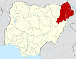 | |
|---|---|---|
This Borno State, Nigeria location article is a stub. You can help Wikipedia by expanding it. |
Текст в блоке "Читать" взят с сайта "Википедия" и доступен по лицензии Creative Commons Attribution-ShareAlike; в отдельных случаях могут действовать дополнительные условия.
Другой контент может иметь иную лицензию. Перед использованием материалов сайта WikiSort.org внимательно изучите правила лицензирования конкретных элементов наполнения сайта.
Другой контент может иметь иную лицензию. Перед использованием материалов сайта WikiSort.org внимательно изучите правила лицензирования конкретных элементов наполнения сайта.
2019-2026
WikiSort.org - проект по пересортировке и дополнению контента Википедии
WikiSort.org - проект по пересортировке и дополнению контента Википедии