world.wikisort.org - Nigeria
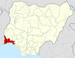
Ifo is a Local Government Area in Ogun State, Nigeria. Its headquarters are in the town of Ifo at 6°49′00″N 3°12′00″E.It has an area of 521 km2 (201 sq mi) and a population of 698,837 at the 2006 census "Adebami-Tella". The postal code of the area is 112.[1]
This article needs additional citations for verification. (October 2020) |
Ifo
Ifo E4 | |
|---|---|
LGA | |
| Nickname: Home of Harmony | |
| Motto: sha sha | |
 Ifo Location in Nigeria | |
| Coordinates: 6°49′N 3°12′E | |
| Country | |
| State | Ogun State |
| Government | |
| • Local Government Chairman | Moji Delana Tawa (APC) |
| Area | |
| • Total | 521 km2 (201 sq mi) |
| Population (2006 census) | |
| • Total | 524,837 |
| Time zone | UTC+1 (WAT) |
| 3-digit postal code prefix | 112 |
| ISO 3166 code | NG.OG.IF |
Transportation
Ifo is connected to nearby Lagos by a railway that was completed in 1899, with a length of 77 kilometres (48 mi). Roads connect it to Lagos as well as Abeokuta, Ilaro, Shagamu, Itori, and Ketou.
Languages
The main language of Ifo is Egba language.
Nearby localities
Nearby major towns include Igbusi, Ilepa, Onihale, Pakoto, Kajola, Lisa, Oyero, Arepo, Seriki, Coker, Ibogun, Matogun, Lambe, Alagbole, Ajuwon and Akute, Ojodu, Isheri all of which constitute their own communities with their own traditional rulers (Obas and Baale's). Together these areas make up Ifo Division. Ifo Division has a large industrial area containing several factories. The town of Ifo itself is home to branches of several established Nigerian banks. Ifo is the fastest growing part-market of the Ogun metropolis, owing in part to increasing influxes of people from Ifo's surrounding towns and villages who are attracted by the town's proximity to Lagos State.
Religion
Inhabitants of Ifo include adherents to several religions, including Christianity, Islam, and traditional worship.
Education
Within greater Ifo there are more than 5 public primary schools and 10 secondary schools. There are also several private nurseries, primary and secondary schools, and 2 tertiary institutions.
Local schools include:
- The prime scholars school, Ifo
- Bookers International School, Ifo
- Rex-Age transnational School
- Emili-Obadina Memorial school, Ajowa.
- Community primary school, Agosi
- The Nations Talents school, Ifo.
- Astute college
- Rabbi Comprehensive College
- Government Primacy School 1,2,3
- Abekoko Grammar School
- Nawair u Deen Grammar School
- Ifo High School
- Adenrele High School
- Don Phillips group of schools
- Estad group of schools olose ifo
- Leah primary school
- Temperance comprehensive college
- Methodist high school
- Government Technical College olose
- Oke pata Senior govt College
- Martins montessori college
- Toaz primary School
- Step Up group of school
- Pakoto High School
- Solu Senior Grammar School
- Ireti Olu Model college, Ifo.
- Access model college
- Ifo City Polytechnic Ifo
- Ar nur International College, Ifo
- Adnaps group of schools
- Double crown group of schools
- New Life Secondary School Ifo
- Ajuwon High School, Iju Ajuwon
- Breakthrough Academy, Awo Akute
- God's Grace School
- Ifo college of technology, Tecno-Bus/stop
Olabisi Onabanjo University is a public university located in the Ibogun area of the town.
References
- "Post Offices- with map of LGA". NIPOST. Archived from the original on 2009-10-07. Retrieved 2009-10-20.
Другой контент может иметь иную лицензию. Перед использованием материалов сайта WikiSort.org внимательно изучите правила лицензирования конкретных элементов наполнения сайта.
WikiSort.org - проект по пересортировке и дополнению контента Википедии
