world.wikisort.org - Niger
Timia is a small town and commune in northern Niger, situated at an oasis in the Aïr Mountains, Agadez Region, Arlit Department. Visitors come to the Tuareg town to see a seasonal waterfall, a former French fort and the nearby ruined town of Assodé.[1] As of 2011, the commune had a total population of 13,588 people.[2]
Timia | |
|---|---|
Commune and town | |
 | |
 Timia Location in Niger | |
| Coordinates: 18°6′52″N 8°46′45″E | |
| Country | |
| Region | Agadez Region |
| Department | Arlit Department |
| Population (2011) | |
| • Total | 13,588 |
| Time zone | UTC+1 (WAT) |
Timia lies south of Iferouane and north of Agadez. The main town lies around 3 km from a stone guelta oasis, which holds water year round. It is also known for its fruit trees, an unusual sight in the Saharan regions of northern Niger.[3]
Gallery
 The valleys of Timia
 The Oasis of Timia
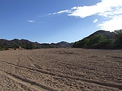 In the valley
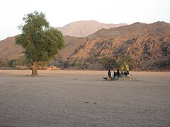 Well in Timia


References
- Decalo, Samuel (1997). Historical Dictionary of the Niger (3rd ed.). Boston & Folkestone: Scarecrow Press. ISBN 0-8108-3136-8.
- "Annuaires_Statistiques" (PDF). Institut National de la Statistique. Retrieved 2 May 2013.
- Geels, Jolijn (2006). Niger. Chalfont St Peter, Bucks / Guilford, Connecticut: Bradt UK / Globe Pequot Press. ISBN 978-1-84162-152-4.
Authority control | |
|---|---|
| General |
|
| National libraries | |
| Other | |
This Niger location article is a stub. You can help Wikipedia by expanding it. |
На других языках
- [en] Timia
[ru] Тимиа
Тимиа — населённый пункт и оазис в Нигере. Административно является сельской коммуной и входит в департамент Арлит региона Агадес. Тимиа расположена на плато Аир посреди Сахары.Текст в блоке "Читать" взят с сайта "Википедия" и доступен по лицензии Creative Commons Attribution-ShareAlike; в отдельных случаях могут действовать дополнительные условия.
Другой контент может иметь иную лицензию. Перед использованием материалов сайта WikiSort.org внимательно изучите правила лицензирования конкретных элементов наполнения сайта.
Другой контент может иметь иную лицензию. Перед использованием материалов сайта WikiSort.org внимательно изучите правила лицензирования конкретных элементов наполнения сайта.
2019-2026
WikiSort.org - проект по пересортировке и дополнению контента Википедии
WikiSort.org - проект по пересортировке и дополнению контента Википедии