world.wikisort.org - New_Zealand
Oban is the principal settlement on Stewart Island / Rakiura, the southernmost inhabited island of the New Zealand archipelago. Oban is located on Halfmoon Bay (sometimes used as an alternative name for the town), on Paterson Inlet. It has aircraft connections with Invercargill and a ferry service to Bluff.
Oban
Pā nui o Hau (Māori) | |
|---|---|
Town | |
| Oban | |
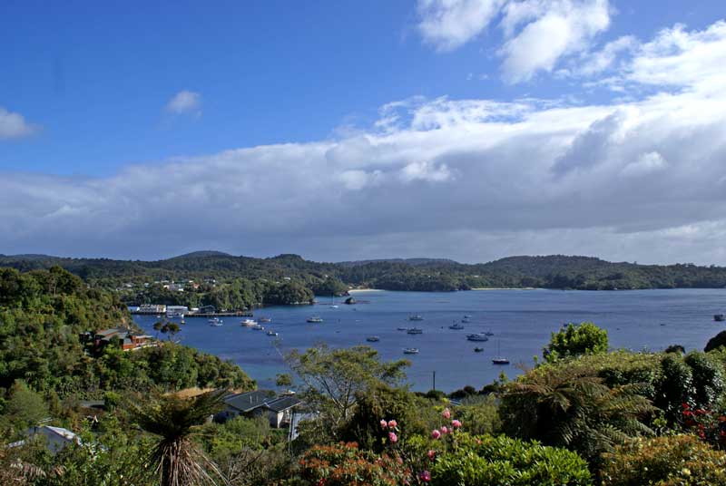 Overlooking Oban and Halfmoon Bay | |
 | |
| Coordinates: 46°54′S 168°08′E | |
| Country | New Zealand |
| Region | Southland |
| District | Southland District |
| Ward | Stewart Island/Rakiura Ward |
| Government | |
| • Territorial Authority | Southland District Council |
| • Regional council | Southland Regional Council |
| Area | |
| • Total | 2.59 km2 (1.00 sq mi) |
| Population (2018 Census)[2] | |
| • Total | 300 |
| • Density | 120/km2 (300/sq mi) |
The settlement was named after Oban in Scotland,[3] (An t-Òban in Scottish Gaelic, meaning The Little Bay), due to the strong influence Scottish settlers had in the south of early colonial New Zealand.
The island has received a moderate boost of commerce and some millions in government funding since tourism increased markedly after the opening of the Rakiura National Park.[4]
Demographics
Oban is defined by Statistics New Zealand as a rural settlement and covers 2.59 km2 (1.00 sq mi).[1] It is part of the wider Stewart Island statistical area.[5]
| Year | Pop. | ±% p.a. |
|---|---|---|
| 2006 | 291 | — |
| 2013 | 273 | −0.91% |
| 2018 | 300 | +1.90% |
| Source: [2] | ||
Oban had a population of 300 at the 2018 New Zealand census, an increase of 27 people (9.9%) since the 2013 census, and an increase of 9 people (3.1%) since the 2006 census. There were 165 households. There were 156 males and 144 females, giving a sex ratio of 1.08 males per female, with 33 people (11.0%) aged under 15 years, 51 (17.0%) aged 15 to 29, 144 (48.0%) aged 30 to 64, and 69 (23.0%) aged 65 or older.
Ethnicities were 92.0% European/Pākehā, 19.0% Māori, 1.0% Pacific peoples, 1.0% Asian, and 1.0% other ethnicities (totals add to more than 100% since people could identify with multiple ethnicities).
Although some people objected to giving their religion, 65.0% had no religion, 26.0% were Christian, 1.0% were Buddhist and 3.0% had other religions.
Of those at least 15 years old, 66 (24.7%) people had a bachelor or higher degree, and 45 (16.9%) people had no formal qualifications. The employment status of those at least 15 was that 150 (56.2%) people were employed full-time, 42 (15.7%) were part-time, and 3 (1.1%) were unemployed.[2]
Climate


The Köppen-Geiger climate classification system classifies its climate as a mid-latitude oceanic (Cfb).[citation needed] Temperatures are mild to cool year-round, with average high temperatures ranging from 17.2 °C (63.0 °F) in January, the warmest month, to 9.9 °C (49.8 °F) in July, the coolest month. The strong oceanic influence here results in small temperature variations. The diurnal temperature variation is quite low, around 7–8 °C (13–14 °F) yearlong, and seasonal temperature variation (the difference between the warmest and coldest months) is about 7 °C (13 °F). Precipitation averages 1,490 mm (58.65 in) per year, and is evenly distributed across the year (see climate chart). Year-round, Oban lies in the direct path of mid-latitude cyclones (low-pressure systems, or depressions) arriving from the Southern Ocean, generally moving from southwest to northeast, or west to east. As such, the climate is predominantly windy, cloudy and rainy; clear days and days with calm to minimal wind are rare.
| Climate data for Oban (1975–2015, Rainfall 1917–2015) | |||||||||||||
|---|---|---|---|---|---|---|---|---|---|---|---|---|---|
| Month | Jan | Feb | Mar | Apr | May | Jun | Jul | Aug | Sep | Oct | Nov | Dec | Year |
| Record high °C (°F) | 27.0 (80.6) |
28.5 (83.3) |
26.5 (79.7) |
29.0 (84.2) |
19.8 (67.6) |
17.5 (63.5) |
16.0 (60.8) |
17.1 (62.8) |
21.3 (70.3) |
23.9 (75.0) |
26.5 (79.7) |
27.2 (81.0) |
29.0 (84.2) |
| Average high °C (°F) | 17.2 (63.0) |
17.1 (62.8) |
15.9 (60.6) |
14.2 (57.6) |
12.0 (53.6) |
10.1 (50.2) |
9.9 (49.8) |
10.7 (51.3) |
12.2 (54.0) |
13.4 (56.1) |
14.6 (58.3) |
16.1 (61.0) |
13.6 (56.5) |
| Daily mean °C (°F) | 13.4 (56.1) |
13.3 (55.9) |
12.1 (53.8) |
10.6 (51.1) |
8.8 (47.8) |
6.7 (44.1) |
6.3 (43.3) |
7.0 (44.6) |
8.4 (47.1) |
9.5 (49.1) |
10.8 (51.4) |
12.4 (54.3) |
9.9 (49.8) |
| Average low °C (°F) | 9.6 (49.3) |
9.4 (48.9) |
8.3 (46.9) |
7.0 (44.6) |
5.5 (41.9) |
3.4 (38.1) |
2.7 (36.9) |
3.5 (38.3) |
4.5 (40.1) |
5.7 (42.3) |
7.0 (44.6) |
8.6 (47.5) |
6.2 (43.2) |
| Record low °C (°F) | 1.0 (33.8) |
1.2 (34.2) |
0.7 (33.3) |
−0.4 (31.3) |
−2 (28) |
−7.3 (18.9) |
−6 (21) |
−3 (27) |
−4.5 (23.9) |
−1.8 (28.8) |
−0.4 (31.3) |
0.6 (33.1) |
−7.3 (18.9) |
| Average rainfall mm (inches) | 133.9 (5.27) |
109.8 (4.32) |
128.2 (5.05) |
132.1 (5.20) |
139.9 (5.51) |
136.9 (5.39) |
113.3 (4.46) |
106.2 (4.18) |
120.9 (4.76) |
134.1 (5.28) |
132.4 (5.21) |
116.4 (4.58) |
1,489.6 (58.65) |
| Average rainy days (≥ 1.0 mm) | 15.3 | 13.6 | 15.4 | 16.0 | 17.9 | 17.8 | 17.0 | 16.5 | 16.0 | 17.0 | 17.0 | 16.1 | 195.5 |
| Average relative humidity (%) | 84.3 | 87.4 | 87.4 | 89.4 | 91.1 | 90.9 | 91.3 | 89.9 | 85.0 | 84.3 | 81.6 | 82.6 | 85.8 |
| Source: CliFlo[6] | |||||||||||||
Education
Halfmoon Bay School / Te Kura o Rakiura caters for years 1 to 8[7] with a roll of 41 students as of July 2022.[8] The school celebrated its centenary in 1974.[9]
References
- "ArcGIS Web Application". statsnz.maps.arcgis.com. Retrieved 4 February 2022.
- "Statistical area 1 dataset for 2018 Census". Statistics New Zealand. March 2020. 7029380–7029382.
- Scottish Place Names Around the World – Fife to Oban (from 'rampantscotland.com'. Accessed 11 October 2008.)
- "Stewart Island gets $5.6m cash boost". The New Zealand Herald. APN Holdings. NZPA. 12 July 2005. Retrieved 1 November 2011.
- island 2018 Census place summary: Stewart Island
- "CliFlo – National Climate Database". NIWA. Retrieved 14 December 2015.
- Education Counts: Halfmoon Bay School
- "New Zealand Schools Directory". New Zealand Ministry of Education. Retrieved 19 August 2022.
- "Halfmoon Bay School (Stewart Island/Rakiura, N.Z.)". National Library of New Zealand. Retrieved 4 February 2022.
На других языках
[de] Oban (Neuseeland)
Oban ist der einzige bewohnte Ort auf der neuseeländischen Insel Stewart Island, der südlichsten bewohnten Insel Neuseelands. Administrativ gehört Stewart Island zur Region Southland.- [en] Oban, New Zealand
[fr] Oban (Nouvelle-Zélande)
Oban est la principale ville de l’Île Stewart ou Rakiura, l’île habitée de l’archipel la plus au sud de la Nouvelle-Zélande.Другой контент может иметь иную лицензию. Перед использованием материалов сайта WikiSort.org внимательно изучите правила лицензирования конкретных элементов наполнения сайта.
WikiSort.org - проект по пересортировке и дополнению контента Википедии