world.wikisort.org - New_Zealand
North East Valley (sometimes spelt Northeast Valley, and often abbreviated to NEV) is a suburb of the New Zealand city of Dunedin.
North East Valley | |
|---|---|
Suburb of Dunedin | |
 | |
 | |
| Coordinates: 45.853°S 170.522°E | |
| Country | New Zealand |
| City | Dunedin |
| Local authority | Dunedin City Council |
| Area | |
| • Land | 468 ha (1,156 acres) |
| Population (June 2021)[2] | |
| • Total | 9,640 |
| Pine Hill | ||
| Maori Hill |
|
|
| Dunedin North | Opoho |
Geography
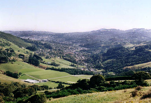
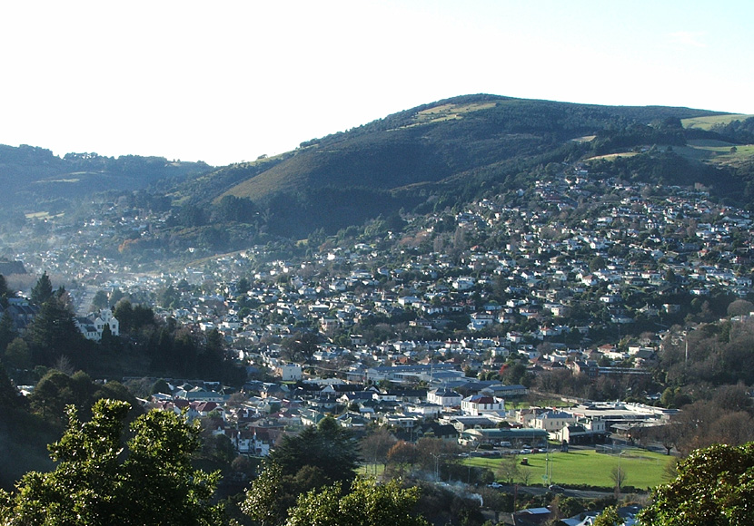
North East Valley sits in the valley of the Lindsay Creek, a tributary of the Water of Leith and on the flanking slopes of Pine Hill and Signal Hill, 3 kilometres (1.9 mi) to the northeast of the city centre.
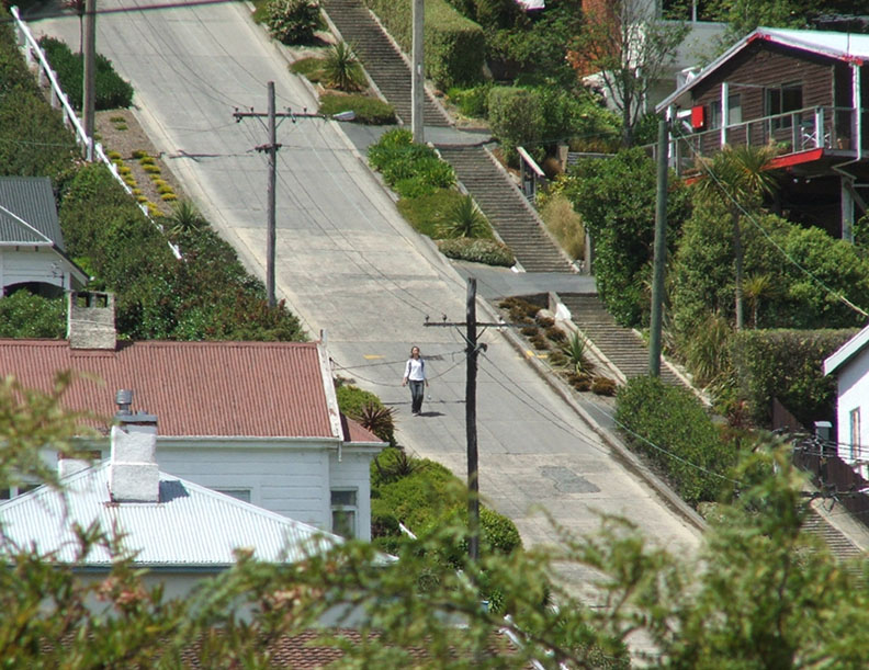
North East Valley is a residential suburb, and is home to a mix of older residents and students from the city's tertiary institutions (the University of Otago and Otago Polytechnic, which lie 1 kilometre (0.62 mi) to the south, beyond the Dunedin Botanic Gardens. The suburb mainly consists of one long street, North Road, and numerous perpendicular side roads which branch off of it, many of which - especially on the eastern (Signal Hill) side - are notoriously steep. One of these, Baldwin Street, is reputedly the world's steepest street. Other than North Road, the suburb's main roads include Blacks Road and Norwood Street.
North East Valley was a separate borough until 1910, when it was amalgamated with the city of Dunedin.[3]
The Gardens, Normanby, and Mount Mera
The term North East Valley is often used to encompass four smaller suburbs within the valley, but more specifically refers to only one, which stretches from approximately Chambers Street north to Chingford Park. Beyond this are two smaller residential areas, Normanby and Mount Mera, and the area below Chambers Street is often simply referred to as The Gardens or The Gardens Corner (after the nearby Dunedin Botanic Gardens).
Normanby is the name of the northern end of North East Valley, at which point Dunedin's urban area gives way to open countryside. The land here is steeply sloping, as it is the foothills of Mount Cargill. The slopes of Mount Cargill itself are densely wooded, and are crisscrossed with walking tracks, some of which start at the Bethune's Gully reserve, at the northern end of Normanby. Mount Mera is an area of state housing sitting on the north facing side of the valley, just above Normanby.
North Road
North Road, originally the main road north out of Dunedin, starts at the Gardens Corner, where it links with Opoho Road and Bank Street (which links with the northern end of Dunedin's main street, George Street). A sports ground at this corner (the Gardens Ground) is the site of cricket and football pitches, and beyond this ground is the southern end of the Dunedin Northern Motorway, part of State Highway 1. The Gardens Ground is the home ground of Northern Football Club and North East Valley Cricket Club.[4]
From the Gardens Corner, North Road runs relatively straight for 2 kilometres (1.2 mi), crossing the Lindsay Creek and continuing to the northeast. Blacks Road, a steep connection to the suburb of Opoho, branches off North Road close to the valley's widest point. Past Chingford Park, the suburban part of the road ends at the junction with Norwood Street, and North Road starts to climb and wind around the end of the valley. From here, it runs through rural farmland, connecting with roads to Port Chalmers and Waitati. Until the construction of the Dunedin Northern Motorway this was a major route out of Dunedin to the north, but is now only lightly used.
Landmarks

Apart from Baldwin Street, North East Valley has several noted landmarks. Two university halls of residence, Knox College and Salmond College lie on the lower slopes to the east of the Gardens Corner, and another, Aquinas College lies on the lower slopes of Pine Hill immediately to the west. Close to this stands another prominent building, the former Santa Sabina Convent, which is visible from much of the northern central city. Another prominent building in the valley is Ross Home, one of the city's major retirement homes, which is located in North Road.
The suburb has several notable parks and gardens, among them Chingford Park, the Quarry Gardens, Forrester Park, and Bethune's Gully.
Chingford Park is a recreational reserve containing historic stone stables, located towards the northern end of North Road. It surrounded the no-longer extant Chingford House, which had been built in 1862. The property was built and landscaped in the 1870s and 1880s by businessman P.C. Neill (one of whose descendants is actor Sam Neill). Among improvements made by Neill to the property include the historic bluestone stables, built in 1880, which still stand as a centre for the park. Chingford Park is popular with walkers, and also contains soccer and cricket grounds, and the city's main archery club. Other notable features of the Park include several giant Macrocarpa trees which stand close to the banks of Lindsay Creek.[5][6]
The Quarry Gardens are a park created from the former Palmer's Quarry, and is located on North Road directly opposite the bottom of Baldwin Street. The quarry was closed in 1980, and was thoroughly landscaped from 1989 into a terraced garden area. The amphitheatre of the old quarry pit has in the past been used as an outdoor music venue, especially during the late 1990s. Several walking tracks climb to the terraces of the former quarry, which have been extensively planted with many species, notably rhododendrons, and other walking paths follow the banks of the Lindsay Creek, connecting with Selwyn Street to the south and Watts road to the north. The gardens are privately owned, but are open to the public year-round.[7]
Forrester Park is a sports ground at the end of Norwood Street. It contains football and rugby pitches and the city's BMX circuit, as well as a dog park and kennel club. Bethune's Gully is also accessed from Norwood Street. It is a secluded 86 hectares (210 acres) reserve which lies at the southernmost foothills of Mount Cargill, and is a popular scenic area. From here, walking tracks ascend the slopes of Cargill. The reserve was originally the site of sawmills and brick kilns operated by David Bethune in the 1880s, and became city council property in 1955.[8]
Demographics
North East Valley covers 4.68 km2 (1.81 sq mi)[1] and had an estimated population of 9,640 as of June 2021,[2] with a population density of 2,060 people per km2.
| Year | Pop. | ±% p.a. |
|---|---|---|
| 2006 | 8,433 | — |
| 2013 | 8,658 | +0.38% |
| 2018 | 9,342 | +1.53% |
| Source: [9] | ||
North East Valley, comprising the statistical areas of North East Valley Chingford, Normanby, North East Valley Knox and Gardens (Dunedin City), had a population of 9,342 at the 2018 New Zealand census, an increase of 684 people (7.9%) since the 2013 census, and an increase of 909 people (10.8%) since the 2006 census. There were 2,757 households. There were 4,398 males and 4,953 females, giving a sex ratio of 0.89 males per female, with 684 people (7.3%) aged under 15 years, 5,787 (61.9%) aged 15 to 29, 2,124 (22.7%) aged 30 to 64, and 744 (8.0%) aged 65 or older.
Ethnicities were 81.5% European/Pākehā, 10.2% Māori, 3.5% Pacific peoples, 12.4% Asian, and 3.4% other ethnicities (totals add to more than 100% since people could identify with multiple ethnicities).
The proportion of people born overseas was 26.4%, compared with 27.1% nationally.
Although some people objected to giving their religion, 58.3% had no religion, 27.1% were Christian, 1.4% were Hindu, 2.0% were Muslim, 1.3% were Buddhist and 4.5% had other religions.
Of those at least 15 years old, 2,013 (23.3%) people had a bachelor or higher degree, and 576 (6.7%) people had no formal qualifications. 405 people (4.7%) earned over $70,000 compared to 17.2% nationally. The employment status of those at least 15 was that 2,118 (24.5%) people were employed full-time, 1,893 (21.9%) were part-time, and 717 (8.3%) were unemployed.[9]
| Name | Area (km2) | Population | Density (per km2) | Households | Median age | Median income |
|---|---|---|---|---|---|---|
| North East Valley Chingford | 1.08 | 1,653 | 1,531 | 633 | 31.8 years | $23,100[10] |
| Normanby | 1.42 | 1,425 | 1,004 | 528 | 43.7 years | $25,200[11] |
| North East Valley Knox | 0.67 | 2,523 | 3,766 | 729 | 22.2 years | $13,000[12] |
| Gardens (Dunedin City) | 1.51 | 3,741 | 2,477 | 867 | 20.3 years | $7,100[13] |
| New Zealand | 37.4 years | $31,800 |
Education
North East Valley Normal School is a state contributing primary school serving years 1 to 6[14] with a roll of 216 students. The school opened in 1851.[15]
Sacred Heart School is a state-integrated Catholic contributing primary school serving years 1 to 6[16] with a roll of 33 students. It started in 1895 at Sacred Heart Church, and moved to the present site ten years later.[17]
Both schools are coeducational. Rolls are as of March 2022,[18]
References
- "ArcGIS Web Application". statsnz.maps.arcgis.com. Retrieved 4 January 2022.
- "Population estimate tables - NZ.Stat". Statistics New Zealand. Retrieved 22 October 2021.
- Herd, J. and Griffiths, G.J. (1980) Discovering Dunedin. Dunedin: John McIndoe. ISBN 0-86868-030-3, p. 82
- Dunedin City Council Gardens Ground page
- Herd, J. and Griffiths, G.J. (1980) Discovering Dunedin. Dunedin: John McIndoe. ISBN 0-86868-030-3, p.43
- Hamel, A. (2007) Dunedin tracks and trails. Dunedin: Silver Peaks Press. ISBN 978-0-473-13772-4, p. 2.08
- Hamel, A. (2007) Dunedin tracks and trails. Dunedin: Silver Peaks Press. ISBN 978-0-473-13772-4, p. 2.06-07
- Herd, J. and Griffiths, G.J. (1980) Discovering Dunedin. Dunedin: John McIndoe. ISBN 0-86868-030-3, p. 31
- "Statistical area 1 dataset for 2018 Census". Statistics New Zealand. March 2020. North East Valley Chingford (351700), Normanby (351900), North East Valley Knox (352000) and Gardens (Dunedin City) (352200).
- 2018 Census place summary: North East Valley Chingford
- 2018 Census place summary: Normanby
- 2018 Census place summary: North East Valley Knox
- 2018 Census place summary: Gardens (Dunedin City)
- Education Counts: North East Valley Normal School
- "About Us". North East Valley Normal School. Retrieved 4 January 2022.
- Education Counts: Sacred Heart School
- "Special Character". Sacred Heart School. Retrieved 4 January 2022.
- "New Zealand Schools Directory". New Zealand Ministry of Education. Retrieved 23 April 2022.
External links
 Media related to North East Valley at Wikimedia Commons
Authority control | |
|---|---|
| General |
|
| National libraries | |
Другой контент может иметь иную лицензию. Перед использованием материалов сайта WikiSort.org внимательно изучите правила лицензирования конкретных элементов наполнения сайта.
WikiSort.org - проект по пересортировке и дополнению контента Википедии