world.wikisort.org - New_Zealand
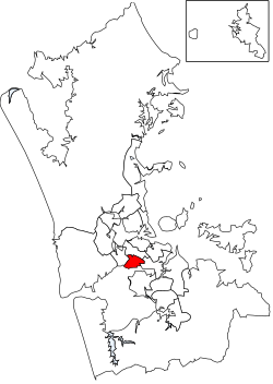
Maungakiekie-Tāmaki is a local government area in Auckland, in New Zealand's Auckland Region. It is governed by the Maungakiekie-Tāmaki Local Board and Auckland Council, and aligns with the council's Maungakiekie-Tāmaki Ward.[1]
Maungakiekie-Tāmaki | |
|---|---|
Local board area | |
 | |
| Country | New Zealand |
| Region | Auckland |
| Territorial authority | Auckland |
| Ward | Maungakiekie-Tāmaki Ward |
| Local board | Maungakiekie-Tāmaki Local Board |
Geography
The area is the south-eastern part of the Auckland isthmus. It includes the suburbs of Glen Innes, Point England, Tāmaki, Panmure, Mount Wellington, Westfield, Penrose, Oranga, Onehunga, Southdown and One Tree Hill.[1]
There are several geographic features, including:
- Maungakiekie / One Tree Hill
- Maungarei / Mount Wellington
- Mutukaroa / Hamlins Hill
- Panmure Basin[1]
Features
The local board includes the major retail areas of Panmure, Onehunga and Sylvia Park. Manufacturing, bulk storage and distribution are major employers.[1]
Mt Smart Stadium is also located within the area.[1]
References
- "Council profile". aucklandcouncil.govt.nz. Auckland Council.
Текст в блоке "Читать" взят с сайта "Википедия" и доступен по лицензии Creative Commons Attribution-ShareAlike; в отдельных случаях могут действовать дополнительные условия.
Другой контент может иметь иную лицензию. Перед использованием материалов сайта WikiSort.org внимательно изучите правила лицензирования конкретных элементов наполнения сайта.
Другой контент может иметь иную лицензию. Перед использованием материалов сайта WikiSort.org внимательно изучите правила лицензирования конкретных элементов наполнения сайта.
2019-2025
WikiSort.org - проект по пересортировке и дополнению контента Википедии
WikiSort.org - проект по пересортировке и дополнению контента Википедии