world.wikisort.org - Netherlands
Wilnis is a village in the Dutch province of Utrecht. It is located in the municipality of De Ronde Venen, between Mijdrecht and Vinkeveen. It is about twenty kilometres south of Amsterdam.
Wilnis | |
|---|---|
Village | |
 Windmill in Wilnis | |
 Wilnis Location in the Netherlands  Wilnis Wilnis (Netherlands) | |
| Coordinates: 52°11′52″N 4°54′0″E | |
| Country | Netherlands |
| Province | Utrecht |
| Municipality | De Ronde Venen |
| Area | |
| • Total | 20.93 km2 (8.08 sq mi) |
| Elevation | −1.8 m (−5.9 ft) |
| Population (2021)[1] | |
| • Total | 6,985 |
| • Density | 330/km2 (860/sq mi) |
| Time zone | UTC+1 (CET) |
| • Summer (DST) | UTC+2 (CEST) |
| Postal code | 3648[1] |
| Dialing code | 0297 |
Wilnis was a separate municipality until 1989.[3]
History
It was first mentioned in 1185 as Wildenisse, and means wilderness.[4] Wilnis started as a peat excavation village in the 12th century, and formed into a long linear settlement. In 1739, the tower of the Dutch Reformed Church collapsed. Between 1877 and 1878, a new church with tower was constructed.[5] In 1840, the village was home to 1,041 people.[6] New neighbourhoods have been built in the polder.[5]
The grist mill De Veenmolen was built in 1823, but might be older. It continued in operation until 1947. It was restored between 1972 and 1973, and is occasionally used for grinding.[7]
Gallery
 Church of Wilnis
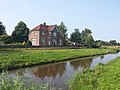 Farm in Wilnis
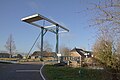 Draw bridge
 Tower De Grote Snip


References
- "Kerncijfers wijken en buurten 2021". Central Bureau of Statistics. Retrieved 28 March 2022.
- "Postcodetool for 3648AA". Actueel Hoogtebestand Nederland (in Dutch). Het Waterschapshuis. Retrieved 28 March 2022.
- Ad van der Meer and Onno Boonstra, Repertorium van Nederlandse gemeenten, KNAW, 2011.
- "Wilnis - (geografische naam)". Etymologiebank (in Dutch). Retrieved 28 March 2022.
1085 reference is a forgery
- Ronald Stenvert & Chris Kolman (1996). "Wilnis" (in Dutch). Zwolle: Waanders. ISBN 90 400 9757 7. Retrieved 28 March 2022.
- "Wilnis". Plaatsengids (in Dutch). Retrieved 28 March 2022.
- "De Veenmolen". Molen database (in Dutch). Retrieved 28 March 2022.
| Authority control |
|
|---|
This Utrecht location article is a stub. You can help Wikipedia by expanding it. |
Другой контент может иметь иную лицензию. Перед использованием материалов сайта WikiSort.org внимательно изучите правила лицензирования конкретных элементов наполнения сайта.
WikiSort.org - проект по пересортировке и дополнению контента Википедии