world.wikisort.org - Netherlands
Westwoud is a village in the Netherlands. It is located in the region of West Friesland in North Holland, about 4 kilometers northeast of Hoorn. The town is part of the municipality of Drechterland and has a population of 1,785.
Westwoud | |
|---|---|
Village | |
 Former town hall of Westwoud | |
 Flag  Coat of arms | |
 Westwoud Location of Westwoud in the Netherlands | |
| Coordinates: 52°41′0″N 5°8′0″E | |
| Country | Netherlands |
| Province | North Holland |
| Municipality | Drechterland |
| Area | |
| • Total | 8.73 km2 (3.37 sq mi) |
| • Land | 8.67 km2 (3.35 sq mi) |
| • Water | 0.05 km2 (0.02 sq mi) |
| Population (2019)[1] | |
| • Total | 1,785 |
| • Density | 205.88/km2 (533.2/sq mi) |
| Demonym | Westwouder |
| Postcode | 1617 |
| Area code | 0228 |
Westwoud received city rights in 1414, along with the villages of Westerblokker and Oosterblokker. This mainly meant it could form its own judicial district, which was abolished in 1811. [2] It was a separate municipality between 1817 and 1979, when it merged with Hoogkarspel and Oosterblokker to form the municipality Bangert, which was changed to Drechterland in 1980.[3]
Gallery
 Village center
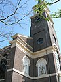 Saint Martin's Church
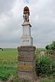 Historic border pole


References
- "Kerncijfers wijken en buurten 2019". CBS StatLine (in Dutch). Statistics Netherlands. Retrieved 10 March 2020.
- "Stede Westwoud". Westfries Archief (in Dutch). Retrieved 8 September 2020.
- Ad van der Meer and Onno Boonstra, Repertorium van Nederlandse gemeenten, KNAW, 2011.
This North Holland location article is a stub. You can help Wikipedia by expanding it. |
На других языках
[de] Westwoud
Westwoud ist eine Ortschaft in der niederländischen Gemeinde Drechterland.- [en] Westwoud
Текст в блоке "Читать" взят с сайта "Википедия" и доступен по лицензии Creative Commons Attribution-ShareAlike; в отдельных случаях могут действовать дополнительные условия.
Другой контент может иметь иную лицензию. Перед использованием материалов сайта WikiSort.org внимательно изучите правила лицензирования конкретных элементов наполнения сайта.
Другой контент может иметь иную лицензию. Перед использованием материалов сайта WikiSort.org внимательно изучите правила лицензирования конкретных элементов наполнения сайта.
2019-2026
WikiSort.org - проект по пересортировке и дополнению контента Википедии
WikiSort.org - проект по пересортировке и дополнению контента Википедии