world.wikisort.org - Netherlands
Stompetoren is a village in the Dutch province of North Holland. It is a part of the municipality of Alkmaar, and lies about 6 km southeast of the city of Alkmaar.
Stompetoren | |
|---|---|
Village | |
 Church with stubby tower | |
 Stompetoren Location in the Netherlands  Stompetoren Location in the province of North Holland in the Netherlands | |
| Coordinates: 52°37′N 4°49′E | |
| Country | Netherlands |
| Province | North Holland |
| Municipality | Alkmaar |
| Area | |
| • Total | 11.15 km2 (4.31 sq mi) |
| Elevation | −3.2 m (−10.5 ft) |
| Population (2021)[1] | |
| • Total | 2,025 |
| • Density | 180/km2 (470/sq mi) |
| Time zone | UTC+1 (CET) |
| • Summer (DST) | UTC+2 (CEST) |
| Postal code | 1841[1] |
| Dialing code | 072 |
History
The village was first mentioned in 1680 as Kerck. The current name means "stubby tower" after the shape of the Dutch Reformed church tower.[3] Stompetoren developed after the Schermer was poldered in 1635 on the intersection of the Noordervaart with the Oterlekerweg.[4]
The Dutch Reformed church is a single aisled church with a baluster on top of the tower, but without a spire. The church was built between 1662 and 1663. Wittenburg is an estate in Renaissance Revival style and surrounded by a moat. It was constructed in 1889 and replaces a farm. Between 1986 and 1987, it was converted to serve as town hall.[4]
Stompetoren was home to 123 people in 1840.[5]
Gallery
 Farm in Stompetoren
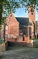 War monument in front the church
 Polder mill


References
- "Kerncijfers wijken en buurten 2021". Central Bureau of Statistics. Retrieved 28 April 2022.
- "Postcodetool for 1841EA". Actueel Hoogtebestand Nederland (in Dutch). Het Waterschapshuis. Retrieved 28 April 2022.
- "Stompetoren - (geografische naam)". Etymologiebank (in Dutch). Retrieved 28 April 2022.
- Ronald Stenvert & Saskia van Ginkel-Meester (2006). "Stompetoren" (in Dutch). Zwolle: Waanders. Retrieved 28 April 2022.
- "Stompetoren". Plaatsengids (in Dutch). Retrieved 28 April 2022.
This North Holland location article is a stub. You can help Wikipedia by expanding it. |
Другой контент может иметь иную лицензию. Перед использованием материалов сайта WikiSort.org внимательно изучите правила лицензирования конкретных элементов наполнения сайта.
WikiSort.org - проект по пересортировке и дополнению контента Википедии