world.wikisort.org - Netherlands
Sint Kruis is a village in the Dutch province of Zeeland. It is located about 4 km east of Aardenburg, in the municipality of Sluis.
Sint Kruis | |
|---|---|
Village | |
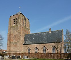
 Dutch Reformed church | |
| Coordinates: 51°16′23″N 3°29′59″E | |
| Country | Netherlands |
| Province | Zeeland |
| Municipality | Sluis |
| Area | |
| • Total | 9.68 km2 (3.74 sq mi) |
| Elevation | 2.1 m (6.9 ft) |
| Population (2021)[1] | |
| • Total | 215 |
| • Density | 22/km2 (58/sq mi) |
| Time zone | UTC+1 (CET) |
| • Summer (DST) | UTC+2 (CEST) |
| Postal code | 4528[1] |
| Dialing code | 0117 |
The village was first mentioned in 1270 as "jndie prochia van sint crues", and refers to the Holy Cross parish of the Saint Bavo's Abbey in Ghent.[3]
The Dutch Reformed church is a three-aisled church which probably dates from the 14th century.[4] The area around Sint Kruis was inundated in 1584 to thwart the progress of the Spanish Army. The land was drained in 1651, and the church was restored in 1652. In 1944, it was damaged by war, and restored between 1948 and 1949.[5]
Sint Kruis was home to 613 people in 1840.[5] It was a separate municipality until 1941, when it was merged with Aardenburg.[6] In 2003, it became part of the municipality of Sluis.[5]
References
- "Kerncijfers wijken en buurten 2021". Central Bureau of Statistics. Retrieved 21 April 2022.
- "Postcodetool for 4528EE". Actueel Hoogtebestand Nederland (in Dutch). Het Waterschapshuis. Retrieved 21 April 2022.
- "Sint Kruis - (geografische naam)". Etymologiebank (in Dutch). Retrieved 21 April 2022.
- "Monumentnummer: 6934 Schoolpad 2 4528 EM te Sint Kruis". Dutch Monuments Register (in Dutch). Retrieved 21 April 2022.
- "Sint Kruis". Plaatsengids (in Dutch). Retrieved 21 April 2022.
- Ad van der Meer and Onno Boonstra, Repertorium van Nederlandse gemeenten, KNAW, 2011.
Другой контент может иметь иную лицензию. Перед использованием материалов сайта WikiSort.org внимательно изучите правила лицензирования конкретных элементов наполнения сайта.
WikiSort.org - проект по пересортировке и дополнению контента Википедии


