world.wikisort.org - Netherlands
Ruinerwold is a village in the Dutch province of Drenthe. It is located in the municipality of De Wolden, about 6 km northeast of Meppel.
Ruinerwold | |
|---|---|
Village | |
 Local church | |
 Coat of arms | |
 Ruinerwold Location in province of Drenthe in the Netherlands  Ruinerwold Ruinerwold (Netherlands) | |
| Coordinates: 52°43′22″N 6°15′2″E | |
| Country | Netherlands |
| Province | Drenthe |
| Municipality | De Wolden |
| Area | |
| • Total | 34.45 km2 (13.30 sq mi) |
| Elevation | 2 m (7 ft) |
| Population (2021)[1] | |
| • Total | 3,950 |
| • Density | 110/km2 (300/sq mi) |
| Time zone | UTC+1 (CET) |
| • Summer (DST) | UTC+2 (CEST) |
| Postal code | 7961[1] |
| Dialing code | 0522 |
History
The village was first mentioned in 1792 as Ruiner wold, and means "woods belonging to Ruinen".[3] Ruinerwold is a road village which developed on a sandy ridge in the 12th century.[4]
The Dutch Reformed church is located in the former hamlet of Blijdenstein which has merged into Ruinerwold.[3][4] It has been built in the 15th century using material of this predecessor which was built around 1150 and had been damaged by fire. The upper part of the tower was restored after a 1730 fire.[4] Ruinerwold used to be home to rich farmers who built large farms which elaborate decorations.[4]
Ruinerwold was home to 1,245 people in 1840.[5] Ruinerwold was a separate municipality until 1998, when it became part of De Wolden.[5]
Hermit family
In October 2019, a 67-year-old man, Gerrit Jan van Dorsten, and his six adult children were discovered, who had lived for nine years in seclusion in a farm house in Ruinerwold. The father was charged with unlawful deprivation of liberty and harming other people's health.[6] The charges were later dropped due to his poor health.[7]
Gallery
 House in Ruinerwold
 Farm in Ruinerwold
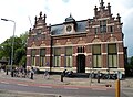 Former town hall
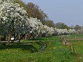 Trees along the road


References
- "Kerncijfers wijken en buurten 2021". Central Bureau of Statistics. Retrieved 12 March 2022.
- "Postcodetool for 7961AA". Actueel Hoogtebestand Nederland (in Dutch). Het Waterschapshuis. Retrieved 12 March 2022.
- "Ruinerwold" (in Dutch). Retrieved 11 April 2022.
- Ronald Stenvert (2001). Ruinerwold (in Dutch). Zwolle: Waanders. p. 61. ISBN 90 400 9454 3. Retrieved 10 April 2022.
- "Ruinerwold". Plaatsengids (in Dutch). Retrieved 12 March 2022.
- Miller, Barbara (18 October 2019). "Father in Dutch 'end of time' family charged with abuse and money laundering as police interview his adult children". ABC News. Sydney, Australia.
- "Dutch farm case: Prosecutors drop abuse charges against 'too ill' father". BBC News. 2021-02-18. Retrieved 2021-04-14.
External links
![]() Media related to Ruinerwold at Wikimedia Commons
Media related to Ruinerwold at Wikimedia Commons
Другой контент может иметь иную лицензию. Перед использованием материалов сайта WikiSort.org внимательно изучите правила лицензирования конкретных элементов наполнения сайта.
WikiSort.org - проект по пересортировке и дополнению контента Википедии