world.wikisort.org - Netherlands
Opijnen is a village in the Dutch province of Gelderland. It is a part of the municipality of West Betuwe, and lies about 10 km southwest of Tiel.
Opijnen | |
|---|---|
Village | |
 Pub in Opijnen | |
 Opijnen Location in the Netherlands  Opijnen Opijnen (Netherlands) | |
| Coordinates: 51°49′40″N 5°17′54″E | |
| Country | Netherlands |
| Province | Gelderland |
| Municipality | West Betuwe |
| Area | |
| • Total | 3.68 km2 (1.42 sq mi) |
| Elevation | 4 m (13 ft) |
| Population (2021)[1] | |
| • Total | 1,195 |
| • Density | 320/km2 (840/sq mi) |
| Time zone | UTC+1 (CET) |
| • Summer (DST) | UTC+2 (CEST) |
| Postal code | 4184[1] |
| Dialing code | 0418 |
Opijnen was a separate municipality until 1818, when it changed its name to Est en Opijnen.[3]
History
It was first mentioned in 1265 as Opynen, and means upstream as compared to Neerijnen.[4] The village developed parallel to the Waal as a stretched out esdorp.[5] In 1265, Opijnen became the property of Raoul de Châtillon, a French nobleman who had fled to Gelre after a dispute with the King of France. A castle was built near the village, however it disappeared in the 16th century.[5] The Dutch Reformed Church was built in 1860 and the tower dates from 1925.[5] In 1840, Opijnen was home to 333 people.[6]
Opijnen is home to the graves of eight American airmen who were shot down on 30 July 1943, and killed while returning to England from a bombing raid over Kassel, Germany. The village honoured the airmen by burying them in their cemetery. From that time and for seventy-five years afterwards, the village honoured these men annually with a formal church service and then a laying of flowers on the graves. In 2006, the village opened a housing complex with eighty-six units. The airmen were further honoured by having the streets in that housing complex named after them.[7]
Gallery
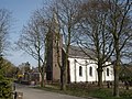 Dutch Reformed Church
 Bridges over the Waal
 Dike house
 House in Opijnen


References
- "Kerncijfers wijken en buurten 2021". Central Bureau of Statistics. Retrieved 24 March 2022.
- "Postcodetool for 4184CE". Actueel Hoogtebestand Nederland (in Dutch). Het Waterschapshuis. 24 July 2019. Retrieved 24 March 2022.
- Ad van der Meer and Onno Boonstra, Repertorium van Nederlandse gemeenten, KNAW, 2011.
- "Opijnen - (geografische naam)". Etymolgiebank (in Dutch). Retrieved 24 March 2022.
- Ronald Stenvert & Sabine Broekhoven (2000). Opijnen (in Dutch). Zwolle: Waanders. ISBN 90-400-9406-3. Retrieved 24 March 2022.
- "Opijnen". Plaatsengids (in Dutch). Retrieved 24 March 2022.
- Washington Post Magazine November 11, 2018
| Wikimedia Commons has media related to Opijnen. |
Authority control | |
|---|---|
| General |
|
| National libraries | |
Другой контент может иметь иную лицензию. Перед использованием материалов сайта WikiSort.org внимательно изучите правила лицензирования конкретных элементов наполнения сайта.
WikiSort.org - проект по пересортировке и дополнению контента Википедии