world.wikisort.org - Netherlands
Noord-Scharwoude (West Frisian: Noôrd-Skerwou) is a village in the municipality of Dijk en Waard in the province of North Holland, Netherlands.
Noord-Scharwoude | |
|---|---|
Village | |
 War memorial in Noord-Scharwoude | |
 Noord-Scharwoude Location in the Netherlands  Noord-Scharwoude Location in the province of North Holland in the Netherlands | |
| Coordinates: 52°42′N 4°49′E | |
| Country | Netherlands |
| Province | North Holland |
| Municipality | Dijk en Waard |
| Area | |
| • Total | 4.12 km2 (1.59 sq mi) |
| Elevation | −0.4 m (−1.3 ft) |
| Population (2021)[1] | |
| • Total | 6,025 |
| • Density | 1,500/km2 (3,800/sq mi) |
| Time zone | UTC+1 (CET) |
| • Summer (DST) | UTC+2 (CEST) |
| Postal code | 1723[1] |
| Dialing code | 0226 |
History
The village was first mentioned in 1094 as Bernardeskercha. The current name means "northern forest belonging to Schoorl". Noord (north) was added to distinguish from Zuid-Scharwoude.[3] Noord-Scharwoude developed in the 11th century as a linear settlement on a dike.[4]
The Catholic John the Baptist church is a three aisled basilica-like church built between 1905 and 1906 as a replacement of an 1856 church.[4]
Noord-Scharwoude was home to 634 people in 1840.[5] It was a separate municipality between 1817 and 1941, when the new municipality Langedijk was created.[6] There used to be a tram line to Alkmaar which was used to transport vegetables to the auction in the village. In 1934, the tram line closed and was reconstructed as a road.[4] The auction no longer exist, and has been converted in apartment buildings. In 2022, Noord-Scharwoude became part of the new municipality of Dijk en Waard.[5]
Gallery
 Former canning factory
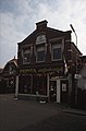 Shop in Noord-Scharwoude
 Houses in Noord-Scharwoude
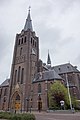 John the Baptist church


See also
- Scharwoude, Langendijk
References
- "Kerncijfers wijken en buurten 2021". Central Bureau of Statistics. Retrieved 29 April 2022.
- "Postcodetool for 1723AA". Actueel Hoogtebestand Nederland (in Dutch). Het Waterschapshuis. Retrieved 29 April 2022.
- "Noord-Scharwoude - (geografische naam)". Etymologiebank (in Dutch). Retrieved 29 April 2022.
- Ronald Stenvert & Saskia van Ginkel-Meester (2006). "Noord-Scharwoude" (in Dutch). Zwolle: Waanders. Retrieved 29 April 2022.
- "Noord-Scharwoude". Plaatsengids (in Dutch). Retrieved 29 April 2022.
- Ad van der Meer and Onno Boonstra, Repertorium van Nederlandse gemeenten, KNAW, 2011.
External links
 Media related to Noord-Scharwoude at Wikimedia Commons
This North Holland location article is a stub. You can help Wikipedia by expanding it. |
Другой контент может иметь иную лицензию. Перед использованием материалов сайта WikiSort.org внимательно изучите правила лицензирования конкретных элементов наполнения сайта.
WikiSort.org - проект по пересортировке и дополнению контента Википедии