world.wikisort.org - Netherlands
Nieuwerbrug (also Nieuwerbrug aan de Rijn) is a village in the Dutch province of South Holland. It is a part of the former municipality of Bodegraven, and lies about five kilometres west of Woerden. Bodegraven has become part of the municipality of Bodegraven-Reeuwijk in 2011. Nieuwerbrug aan de Rijn is the spelling since 2009 to distinguish from Nieuwebrug in Friesland.[3]
Nieuwerbrug
Nieuwerbrug aan de Rijn | |
|---|---|
Village | |
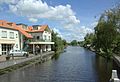
 Centre of Nieuwerbrug with the church and toll bridge | |
 Nieuwerbrug Location in the province of South Holland in the Netherlands  Nieuwerbrug Location in the Netherlands | |
| Coordinates: 52°4′37″N 4°48′56″E | |
| Country | Netherlands |
| Province | South Holland |
| Municipality | Bodegraven-Reeuwijk |
| Area | |
| • Total | 12.02 km2 (4.64 sq mi) |
| Elevation | 0.3 m (1.0 ft) |
| Population (2021)[1] | |
| • Total | 1,790 |
| • Density | 150/km2 (390/sq mi) |
| Time zone | UTC+1 (CET) |
| • Summer (DST) | UTC+2 (CEST) |
| Postal code | 2415[1] |
| Dialing code | 0348 |
Nieuwerbrug is a dike village which developed along the bridge over the Oude Rijn which was built in 1510. The bridge became a toll bridge from 1651 to the present. A little tower was built next to the bridge between 1913 and 1914.[4]
Gallery
 View from the bridge
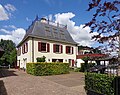 Villa Weijpoort
 De Volharding


References
- "Kerncijfers wijken en buurten 2021". Central Bureau of Statistics. Retrieved 2 May 2022.
- "Postcodetool for 2415AA". Actueel Hoogtebestand Nederland (in Dutch). Het Waterschapshuis. Retrieved 2 May 2022.
- "Nieuwerbrug aan de Rijn". Plaatsengids (in Dutch). Retrieved 2 May 2022.
- Ronald Stenvert & Sabine Broekhoven (2004). "Nieuwerbrug" (in Dutch). Zwolle: Waanders. ISBN 90 400 9034 3. Retrieved 2 May 2022.
Authority control | |
|---|---|
| General |
|
| National libraries | |
This South Holland location article is a stub. You can help Wikipedia by expanding it. |
Текст в блоке "Читать" взят с сайта "Википедия" и доступен по лицензии Creative Commons Attribution-ShareAlike; в отдельных случаях могут действовать дополнительные условия.
Другой контент может иметь иную лицензию. Перед использованием материалов сайта WikiSort.org внимательно изучите правила лицензирования конкретных элементов наполнения сайта.
Другой контент может иметь иную лицензию. Перед использованием материалов сайта WikiSort.org внимательно изучите правила лицензирования конкретных элементов наполнения сайта.
2019-2026
WikiSort.org - проект по пересортировке и дополнению контента Википедии
WikiSort.org - проект по пересортировке и дополнению контента Википедии