world.wikisort.org - Netherlands
Luchtenburg is a hamlet in the Dutch province of Gelderland. It is a part of the municipality of Buren, and is located in about 8 km southwest of Veenendaal.[2]
Luchtenburg | |
|---|---|
Hamlet | |
 Street view of Luchtenburg | |
 Luchtenburg Location in the Netherlands  Luchtenburg Luchtenburg (Netherlands) | |
| Coordinates: 51°58′11″N 5°29′15″E | |
| Country | Netherlands |
| Province | Gelderland |
| Municipality | Buren |
| Elevation | 7 m (23 ft) |
| Time zone | UTC+1 (CET) |
| • Summer (DST) | UTC+2 (CEST) |
| Postal code | 4031 |
| Dialing code | 0344 |
Luchtenburg is not a statistical entity,[3] and the postal authorities have placed it under Ingen.[4] The hamlet consists of about 40 houses.[5]
Gallery
 Farm in Luchtenburg
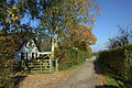 Farm in Luchtenburg


References
- "Postcodetool for 4031JA". Actueel Hoogtebestand Nederland (in Dutch). Het Waterschapshuis. Retrieved 21 March 2022.
- ANWB Topografische Atlas Nederland, Topografische Dienst and ANWB, 2005.
- "Kerncijfers wijken en buurten 2021". Central Bureau of Statistics. Retrieved 21 March 2022.
not found
- "Postcode 4031 in Ingen". Postcode bij adres (in Dutch). Retrieved 21 March 2022.
- "Luchtenburg". Plaatsengids (in Dutch). Retrieved 21 March 2022.
This Gelderland location article is a stub. You can help Wikipedia by expanding it. |
Текст в блоке "Читать" взят с сайта "Википедия" и доступен по лицензии Creative Commons Attribution-ShareAlike; в отдельных случаях могут действовать дополнительные условия.
Другой контент может иметь иную лицензию. Перед использованием материалов сайта WikiSort.org внимательно изучите правила лицензирования конкретных элементов наполнения сайта.
Другой контент может иметь иную лицензию. Перед использованием материалов сайта WikiSort.org внимательно изучите правила лицензирования конкретных элементов наполнения сайта.
2019-2026
WikiSort.org - проект по пересортировке и дополнению контента Википедии
WikiSort.org - проект по пересортировке и дополнению контента Википедии