world.wikisort.org - Netherlands
Kootwijk (West Low German: Kodek) (population estimate: 280) is a small village in the municipality Barneveld, located in the middle of the Netherlands, in the province of Gelderland.
Kootwijk | |
|---|---|
Village | |
 Church | |
 Kootwijk Location in the province of Gelderland  Kootwijk Kootwijk (Netherlands) | |
| Coordinates: 52°11′2″N 5°46′23″E | |
| Country | Netherlands |
| Province | Gelderland |
| Municipality | Barneveld |
| Area | |
| • Total | 32.19 km2 (12.43 sq mi) |
| Elevation | 29 m (95 ft) |
| Population (2021)[1] | |
| • Total | 275 |
| • Density | 8.5/km2 (22/sq mi) |
| Time zone | UTC+1 (CET) |
| • Summer (DST) | UTC+2 (CEST) |
| Postal code | 3775[1] |
| Dialing code | 0577 |
History
It was first mentioned between 1333 and 1334 as Coetwijc, and means "village with little houses".[3] In 1840, it was home to 66 people.[4] The Dutch Reformed Church dates from the 16th century, but has been extensively modified in 1930. Up to 1900, it was surrounded by heath and mainly home to shepherds.[5] South of Kootwijk is the Kootwijkerzand, a sand dune area of 7 km2, the largest in Europe.
Between 1918 and 1921, the radio transmitter Radio Kootwijk was constructed to the east of Kootwijk to improve communication with the Dutch East Indies (nowadays Indonesia).[5] In 1950, the village was hit by an F3-F4 tornado. One person was injured, however 460 hectares (1,100 acres) of forest was destroyed. A living van was turned over three times, however the occupants survived with minor injuries.[4]
Transportation
Kootwijk is bypassed in the north by Rijksweg 1 (A1) / European route E30 (E 30) at exit 18, where Provincial road N302 (N302) branches off to the north.
Gallery
![Five sheep by Karin Beek [nl]](//upload.wikimedia.org/wikipedia/commons/thumb/4/45/20161004_De_vijf_schapen_door_Karin_Beek_Kootwijk.jpg/120px-20161004_De_vijf_schapen_door_Karin_Beek_Kootwijk.jpg) Five sheep by Karin Beek
Five sheep by Karin Beek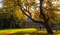 Kootwijk in autumn
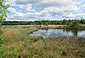 Kootwijkerveen
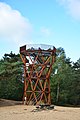 Watch tower at Kootwijkerzand
![Five sheep by Karin Beek [nl]](http://upload.wikimedia.org/wikipedia/commons/4/45/20161004_De_vijf_schapen_door_Karin_Beek_Kootwijk.jpg)


References
- "Kerncijfers wijken en buurten 2021". Central Bureau of Statistics. Retrieved 19 March 2022.
- "Postcodetool for 3775KA". Actueel Hoogtebestand Nederland (in Dutch). Het Waterschapshuis. Retrieved 19 March 2022.
- "Kootwijk - (geografische naam)". Etymologiebank (in Dutch). Retrieved 19 March 2022.
- "Kootwijk". Plaatsengids (in Dutch). Retrieved 19 March 2022.
- Ronald Stenvert & Sabine Broekhoven (2000). "Kootwijk" (in Dutch). Zwolle: Waanders. ISBN 90 400 9406 3. Retrieved 19 March 2022.
Authority control | |
|---|---|
| General |
|
| National libraries | |
This Gelderland location article is a stub. You can help Wikipedia by expanding it. |
Другой контент может иметь иную лицензию. Перед использованием материалов сайта WikiSort.org внимательно изучите правила лицензирования конкретных элементов наполнения сайта.
WikiSort.org - проект по пересортировке и дополнению контента Википедии