world.wikisort.org - Netherlands
Groenekan is a village in the Dutch province of Utrecht. It is a part of the municipality of De Bilt, and lies about 3 km west of Bilthoven.
Groenekan | |
|---|---|
Village | |
 Villa in Groenekan | |
 Groenekan Location in the Netherlands  Groenekan Groenekan (Netherlands) | |
| Coordinates: 52°7′27″N 5°8′56″E | |
| Country | Netherlands |
| Province | Utrecht |
| Municipality | De Bilt |
| Area | |
| • Total | 12.14 km2 (4.69 sq mi) |
| Elevation | 2 m (7 ft) |
| Population (2021)[1] | |
| • Total | 1,975 |
| • Density | 160/km2 (420/sq mi) |
| Time zone | UTC+1 (CET) |
| • Summer (DST) | UTC+2 (CEST) |
| Postal code | 3737[1] |
| Dialing code | 0346 |
History
It was first mentioned in 1607 as De Groene Kan, and is a reference to an inn with a green pot as display.[3] Groenekan was a road village in a peat excavation area to the east of the Vecht.[4] In 1840, it was home to 237 people.[5]
In 1863, Groenekan was cut in two by the Utrecht-Hilversum railway line.[4] Two railway stations were built, but closed in 1922 and 1938.[6][7] Between 1867 and 1870, two forts were built near Groenekan as part of the Stelling van Amsterdam: Fort Voordorp and Fort Ruigenhoek. Between 1914 and 1918, and 1939 and 1940, bunkers were constructed around the village.[4]
Gallery
 Farm in Groenekan
 Church of Groenekan
 Huis Beukenburg (c. 1920)
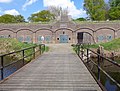 Fort Ruigenhoek


See also
- Rudolf van Reest
References
- "Kerncijfers wijken en buurten 2021". Central Bureau of Statistics. Retrieved 28 March 2022.
- "Postcodetool for 3737AA". Actueel Hoogtebestand Nederland (in Dutch). Het Waterschapshuis. Retrieved 28 March 2022.
- "Groenekan - (geografische naam)". Etymologiebank (in Dutch). Retrieved 28 March 2022.
- Ronald Stenvert & Chris Kolman (1996). "Groenekan" (in Dutch). Zwolle: Waanders. ISBN 90 400 9757 7. Retrieved 28 March 2022.
- "Groenekan". Plaatsengids (in Dutch). Retrieved 28 March 2022.
- "Station Groenekanschedijk". Stationsweb (in Dutch). Retrieved 28 March 2022.
- "Station Groenekan West". Stationsweb (in Dutch). Retrieved 28 March 2022.
This Utrecht location article is a stub. You can help Wikipedia by expanding it. |
Другой контент может иметь иную лицензию. Перед использованием материалов сайта WikiSort.org внимательно изучите правила лицензирования конкретных элементов наполнения сайта.
WikiSort.org - проект по пересортировке и дополнению контента Википедии