world.wikisort.org - Netherlands
Gieterveen is a village in the Dutch province of Drenthe. It is a part of the municipality of Aa en Hunze, and lies about 19 km east of Assen.
Gieterveen | |
|---|---|
Village | |
 The windmill | |
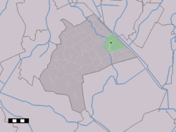 The village centre (dark green) and the statistical district (light green) of Gieterveen in the municipality of Aa en Hunze. | |
 Gieterveen Location in the Netherlands  Gieterveen Gieterveen (Netherlands) | |
| Coordinates: 53°1′38″N 6°50′16″E | |
| Country | Netherlands |
| Province | Drenthe |
| Municipality | Aa en Hunze |
| Area | |
| • Total | 15.40 km2 (5.95 sq mi) |
| Elevation | 4 m (13 ft) |
| Population (2021)[1] | |
| • Total | 875 |
| • Density | 57/km2 (150/sq mi) |
| Time zone | UTC+1 (CET) |
| • Summer (DST) | UTC+2 (CEST) |
| Postal code | 9511[1] |
| Dialing code | 0599 |
History
The village was first mentioned in 1458 as "Gheter vene", and means "peat (colony) belonging to Gieten.[3] Gieterveen developed after 1450 on a sandy ridge of the Hondsrug as a satellite of Gieten.[4] It started as a peat excavation colony, and the rent of the houses used to be paid by peat.[5] In 1840, it became an independent parish.[4]
The Dutch Reformed church dates from 1840 and has been built in a neoclassic style. Around 1915, a consistory has been added to the back of the church.[4]
Gieterveen was home to 595 people in 1840. The figure seems high, but there were probably barracks for the nearby peat excavation projects.[5]
Gallery
 Protestant church
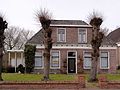 Former clergy house
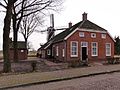 Miller's home
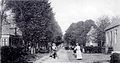 Gieterveen in 1905


References
- "Kerncijfers wijken en buurten 2021". Central Bureau of Statistics. Retrieved 10 April 2022.
two entries
- "Postcodetool for 9511PA". Actueel Hoogtebestand Nederland (in Dutch). Het Waterschapshuis. Retrieved 10 April 2022.
- "Gieterveen - (geografische naam)". Etymologiebank (in Dutch). Retrieved 10 April 2022.
- Ronald Stenvert (2001). Gieterveen (in Dutch). Zwolle: Waanders. p. 61. ISBN 90 400 9454 3. Retrieved 10 April 2022.
- "Gieterveen". Plaatsengids (in Dutch). Retrieved 10 April 2022.
This Drenthe location article is a stub. You can help Wikipedia by expanding it. |
Другой контент может иметь иную лицензию. Перед использованием материалов сайта WikiSort.org внимательно изучите правила лицензирования конкретных элементов наполнения сайта.
WikiSort.org - проект по пересортировке и дополнению контента Википедии