world.wikisort.org - Netherlands
Garyp (Dutch: Garijp[3]) is a village in Tytsjerksteradiel municipality in the province of Friesland, the Netherlands. It had a population of around 1,894 in January 2017.[4]
Garyp
Garijp | |
|---|---|
Village | |
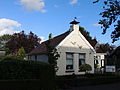
 St Peter's Church | |
 Coat of arms | |
 Location of the village in Tytsjerksteradiel | |
 Garyp Location in the Netherlands  Garyp Garyp (Netherlands) | |
| Coordinates: | |
| Country | |
| Province | |
| Municipality | |
| Area | |
| • Total | 18.26 km2 (7.05 sq mi) |
| Elevation | −0.1 m (−0.3 ft) |
| Population (2021)[1] | |
| • Total | 1,895 |
| • Density | 100/km2 (270/sq mi) |
| Postal code | 9263[1] |
| Dialing code | 0511 |
History
The village was first mentioned between 1325 to 1336 as Garipe, and means "village of the river bank".[5] Garyp developed into a stretched out village on a sandy ridge. The current Dutch Reformed church dates from 1838, however the first church was built around 1100.[6] Around 1930, the peat in the region was excavated.[7]
Garyp was home to 620 people in 1840.[7]
Gallery
 Village view
 Farm Binnenrust
- House in Garyp
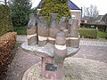 Village community statue


References
- "Kerncijfers wijken en buurten 2021". Central Bureau of Statistics. Retrieved 5 April 2022.
two entries
- "Postcodetool for 9263AA". Actueel Hoogtebestand Nederland (in Dutch). Het Waterschapshuis. Retrieved 5 April 2022.
- Taalunie (2019). "Friese namen" (in Dutch). Retrieved 18 November 2019.
- Overzicht inwonersaantal Tytsjerksteradiel - Tytsjerksteradiel
- "Garyp - (geografische naam)". Etymologiebank (in Dutch). Retrieved 5 April 2022.
- Ronald Stenvert & Sabine Broekhoven (2000). "Garyp" (in Dutch). Zwolle: Waanders. ISBN 90 400 9476 4. Retrieved 5 April 2022.
- "Garyp". Plaatsengids (in Dutch). Retrieved 5 April 2022.
Wikimedia Commons has media related to Garyp.
| Administrative Centre | 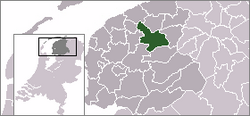 | |
|---|---|---|
| Villages |
| |
| Hamlets |
| |
| Landmarks |
| |
| Lakes |
| |
This Friesland location article is a stub. You can help Wikipedia by expanding it. |
Текст в блоке "Читать" взят с сайта "Википедия" и доступен по лицензии Creative Commons Attribution-ShareAlike; в отдельных случаях могут действовать дополнительные условия.
Другой контент может иметь иную лицензию. Перед использованием материалов сайта WikiSort.org внимательно изучите правила лицензирования конкретных элементов наполнения сайта.
Другой контент может иметь иную лицензию. Перед использованием материалов сайта WikiSort.org внимательно изучите правила лицензирования конкретных элементов наполнения сайта.
2019-2026
WikiSort.org - проект по пересортировке и дополнению контента Википедии
WikiSort.org - проект по пересортировке и дополнению контента Википедии