world.wikisort.org - Netherlands
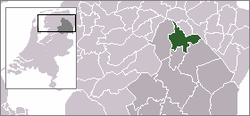
Eelde (Dutch pronunciation: [ˈeːldə]) is a town in the Dutch province of Drenthe. It is a part of the municipality of Tynaarlo, and lies about 9 km south of Groningen. Groningen Airport Eelde is located near the village.
Eelde | |
|---|---|
Town | |
 Former townhall in 2010 | |
 | |
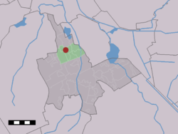 The village (dark red) and the statistical district (light green) of Eelde in the municipality of Tynaarlo. | |
| Coordinates: 53°08′00″N 6°34′00″E | |
| Country | Netherlands |
| Province | Drenthe |
| Municipality | Tynaarlo |
| Population | |
| • Total | 7,000 |
| Eelde-Paterswolde ca. 11,000 | |
| Time zone | UTC+1 (CET) |
| • Summer (DST) | UTC+2 (CEST) |
Eelde was a separate municipality until 1998, when it was merged with Vries and Zuidlaren.[1]
During the 20th century, the villages of Eelde and Paterswolde have merged into one, "Eelde-Paterswolde". In 2012, Eelde counted 6,660 inhabitants, and Paterswolde 3,680, together 10,340 inhabitants.[2]
Its major attractions are Groningen Airport Eelde, museum "De Buitenplaats", the annual flower parade and the lake "Paterswoldse meer".
Climate
| Climate data for Eelde (1991−2020 normals, extremes 1906−present) | |||||||||||||
|---|---|---|---|---|---|---|---|---|---|---|---|---|---|
| Month | Jan | Feb | Mar | Apr | May | Jun | Jul | Aug | Sep | Oct | Nov | Dec | Year |
| Record high °C (°F) | 14.5 (58.1) |
18.9 (66.0) |
24.0 (75.2) |
28.8 (83.8) |
32.8 (91.0) |
33.8 (92.8) |
36.9 (98.4) |
36.3 (97.3) |
32.6 (90.7) |
27.4 (81.3) |
19.4 (66.9) |
15.4 (59.7) |
36.9 (98.4) |
| Average high °C (°F) | 5.2 (41.4) |
6.0 (42.8) |
9.5 (49.1) |
14.2 (57.6) |
17.6 (63.7) |
20.4 (68.7) |
22.7 (72.9) |
22.6 (72.7) |
19.0 (66.2) |
14.2 (57.6) |
9.0 (48.2) |
5.9 (42.6) |
13.9 (57.0) |
| Daily mean °C (°F) | 2.8 (37.0) |
3.0 (37.4) |
5.5 (41.9) |
9.0 (48.2) |
12.5 (54.5) |
15.4 (59.7) |
17.5 (63.5) |
17.3 (63.1) |
14.1 (57.4) |
10.3 (50.5) |
6.3 (43.3) |
3.5 (38.3) |
9.8 (49.6) |
| Average low °C (°F) | 0.1 (32.2) |
−0.1 (31.8) |
1.4 (34.5) |
3.7 (38.7) |
7.0 (44.6) |
9.9 (49.8) |
12.2 (54.0) |
11.9 (53.4) |
9.4 (48.9) |
6.3 (43.3) |
3.2 (37.8) |
0.8 (33.4) |
5.5 (41.9) |
| Record low °C (°F) | −22.0 (−7.6) |
−22.9 (−9.2) |
−18.4 (−1.1) |
−8.1 (17.4) |
−3.4 (25.9) |
0.1 (32.2) |
2.5 (36.5) |
3.2 (37.8) |
−1.0 (30.2) |
−6.9 (19.6) |
−13.6 (7.5) |
−22.0 (−7.6) |
−22.9 (−9.2) |
| Average precipitation mm (inches) | 72.7 (2.86) |
54.7 (2.15) |
54.1 (2.13) |
41.3 (1.63) |
57.9 (2.28) |
65.0 (2.56) |
85.0 (3.35) |
77.8 (3.06) |
75.4 (2.97) |
71.4 (2.81) |
70.0 (2.76) |
79.4 (3.13) |
804.7 (31.68) |
| Average relative humidity (%) | 89.5 | 87.0 | 82.8 | 77.5 | 77.3 | 79.0 | 79.8 | 81.3 | 84.8 | 87.6 | 91.1 | 91.2 | 84.1 |
| Mean monthly sunshine hours | 60.7 | 86.1 | 139.0 | 188.7 | 218.0 | 198.6 | 212.3 | 196.3 | 150.7 | 112.9 | 63.4 | 56.1 | 1,682.8 |
| Percent possible sunshine | 24.0 | 30.8 | 37.7 | 45.0 | 44.4 | 39.3 | 41.8 | 42.8 | 39.4 | 34.2 | 24.2 | 23.7 | 35.6 |
| Source: Royal Netherlands Meteorological Institute[3][4] | |||||||||||||
References
- Ad van der Meer and Onno Boonstra, Repertorium van Nederlandse gemeenten, KNAW, 2011.
- Statistics Netherlands (CBS)
- "Weerstatistieken Eelde". Royal Netherlands Meteorological Institute. Retrieved July 2, 2022.
- "Klimaatviewer 1991-2020". Royal Netherlands Meteorological Institute. Retrieved July 2, 2022.
External links
 Media related to Eelde at Wikimedia Commons
- Eelde, een lied van George Welling on YouTube
Authority control | |
|---|---|
| General |
|
| National libraries | |
| Other |
|
This Drenthe location article is a stub. You can help Wikipedia by expanding it. |
На других языках
- [en] Eelde
[ru] Элде
Элде (нидерл. Eelde) — город в общине Тинарло провинции Дренте, Нидерланды. Расположен в 9 км к югу от Гронингена. Возле населённого пункта находится Гронингенский аэропорт Элде.Текст в блоке "Читать" взят с сайта "Википедия" и доступен по лицензии Creative Commons Attribution-ShareAlike; в отдельных случаях могут действовать дополнительные условия.
Другой контент может иметь иную лицензию. Перед использованием материалов сайта WikiSort.org внимательно изучите правила лицензирования конкретных элементов наполнения сайта.
Другой контент может иметь иную лицензию. Перед использованием материалов сайта WikiSort.org внимательно изучите правила лицензирования конкретных элементов наполнения сайта.
2019-2026
WikiSort.org - проект по пересортировке и дополнению контента Википедии
WikiSort.org - проект по пересортировке и дополнению контента Википедии