world.wikisort.org - Netherlands
Donkerbroek is a village in the municipality of Ooststellingwerf, the Netherlands. In 2017, it had a population of around 1,830.[3]
Donkerbroek | |
|---|---|
Village | |
 Donkerbroek Church | |
 Flag  Coat of arms | |
 Location in Ooststellingwerf municipality | |
 Donkerbroek Location in the Netherlands  Donkerbroek Donkerbroek (Netherlands) | |
| Coordinates: | |
| Country | |
| Province | |
| Municipality | |
| Area | |
| • Total | 22.31 km2 (8.61 sq mi) |
| Elevation | 5 m (16 ft) |
| Population (2021)[1] | |
| • Total | 1,895 |
| • Density | 85/km2 (220/sq mi) |
| Postal code | 8435[1] |
| Dialing code | 0516 |
History
The village was first mentioned in 1408 as Duncbrueck. The etymology is unclear.[4] Donkerbroek probably developed in the 13th century along the Heerenveen to Assen road. Even though, it is located in a peat region, it is not an excavation village. The Dutch Reformed church was built in 1714 as a replacement of an older church.[5] The church has a standalone belfry with two bells which have existed since at least 1723. In 1840, Donkerbroek was home to 669 people.[6]
Around 1900, some industry appeared along the canal. The cooperative purchasing association "Friesland" is an industrial complex from 1911 which is built in a combination of Rationalism and Jugendstil.[5] The building contained a fodder factory.[7]
Gallery
 Bridge in Donkerbroek
 Huis Ontwijk
 Trabants and Simcas in Donkerbroek
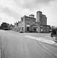 Complex of "Friesland"


References
- "Kerncijfers wijken en buurten 2021". Central Bureau of Statistics. Retrieved 1 April 2022.
- "Postcodetool for 8435SB". Actueel Hoogtebestand Nederland (in Dutch). Het Waterschapshuis. Retrieved 1 April 2022.
- Villages Archived 2017-09-28 at the Wayback Machine - Ooststellingwerf Municipality (in Dutch)
- "Donkerbroek - (geografische naam)". Etymologiebank (in Dutch). Retrieved 1 April 2022.
- Ronald Stenvert & Sabine Broekhoven (2000). "Kollum" (in Dutch). Zwolle: Waanders. ISBN 90 400 9476 4. Retrieved 1 April 2022.
- "Donkerbroek" (in Dutch). Retrieved 1 April 2022.
- "Landbouwbank Steenwijk met Friese coöperaties". Leeuwarder Courant (in Dutch). 17 December 1966. Retrieved 1 April 2022.
External links
 Media related to Donkerbroek at Wikimedia Commons
- Site of Donkerbroek
This Friesland location article is a stub. You can help Wikipedia by expanding it. |
Другой контент может иметь иную лицензию. Перед использованием материалов сайта WikiSort.org внимательно изучите правила лицензирования конкретных элементов наполнения сайта.
WikiSort.org - проект по пересортировке и дополнению контента Википедии