world.wikisort.org - Netherlands
Cattenbroek is a hamlet in the Dutch province of Utrecht. It is a part of the municipality of Montfoort, and lies about 4 km east of Woerden.
Cattenbroek | |
|---|---|
Hamlet | |
 Cattenbroekerdijk (dike) | |
 Cattenbroek Location in the Netherlands  Cattenbroek Cattenbroek (Netherlands) | |
| Coordinates: 52°3′50″N 4°56′20″E | |
| Country | Netherlands |
| Province | Utrecht |
| Municipality | Montfoort |
| Area | |
| • Total | 4.16 km2 (1.61 sq mi) |
| Population (2021)[1] | |
| • Total | 85 |
| • Density | 20/km2 (53/sq mi) |
| Time zone | UTC+1 (CET) |
| • Summer (DST) | UTC+2 (CEST) |
| Postal code | 3461[1] |
| Dialing code | 0348 |
The hamlet was first mentioned in 1217 as Cattenbroec, and means inferior swampy land.[2] The postal authorities have placed it under Linschoten.[3] Cattenbroek does not have place name signs. In 1840, it was home to 75 people. There is a public beach on the lake near Cattenbroek.[4]
Gallery
 Farm in Cattenbroek
 Farm Helena in Cattenbroek
 Drawing of inn De Lindeboom (1729)
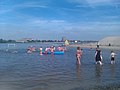 Lake and beach near Cattenbroek


References
- "Kerncijfers wijken en buurten 2021". Central Bureau of Statistics. Retrieved 28 March 2022.
- "Cattenbroek - (geografische naam)". Etymologiebank (in Dutch). Retrieved 28 March 2022.
- "Postcode 3461 in Linschoten". Postcode bij adres (in Dutch). Retrieved 28 March 2022.
- "Cattenbroek". Plaatsengids (in Dutch). Retrieved 28 March 2022.
| Wikimedia Commons has media related to Cattenbroek. |
This Utrecht location article is a stub. You can help Wikipedia by expanding it. |
Текст в блоке "Читать" взят с сайта "Википедия" и доступен по лицензии Creative Commons Attribution-ShareAlike; в отдельных случаях могут действовать дополнительные условия.
Другой контент может иметь иную лицензию. Перед использованием материалов сайта WikiSort.org внимательно изучите правила лицензирования конкретных элементов наполнения сайта.
Другой контент может иметь иную лицензию. Перед использованием материалов сайта WikiSort.org внимательно изучите правила лицензирования конкретных элементов наполнения сайта.
2019-2026
WikiSort.org - проект по пересортировке и дополнению контента Википедии
WikiSort.org - проект по пересортировке и дополнению контента Википедии