world.wikisort.org - Netherlands
Buitenpost (Bûtenpost in West Frisian) is a village in north-east Friesland in the Netherlands.
Buitenpost
Bûtenpost | |
|---|---|
Village | |
 Maria Church | |
 Flag  Coat of arms | |
 Location in Achtkarspelen municipality | |
 Buitenpost Location in the Netherlands | |
| Coordinates: | |
| Country | |
| Province | |
| Municipality | |
| Area | |
| • Total | 18.55 km2 (7.16 sq mi) |
| Elevation | 0.1 m (0.3 ft) |
| Population (2021)[1] | |
| • Total | 5,770 |
| • Density | 310/km2 (810/sq mi) |
| Postal code | 9285[1] |
| Dialing code | 0511-0512 |
| Website | Official |
It lies approximately halfway between the cities of Leeuwarden (the capital of Friesland) and Groningen, in the northern part of the municipality of Achtkarspelen. With 5,762 inhabitants,[3] Buitenpost is the second largest settlement in the municipality.[1]
Buitenpost is home to the Netherlands' largest botanical herbal garden.[4][5]
History
The village was first mentioned in 1388 as Post, and means outside bridge. Buiten (outside) was added to distinguish from the hamlet of Lutkepost.[6] Buitenpost is a road village which developed along the main road from Leeuwarden to Groningen, and became the capital of the grietenij (predecessor of a municipality) Achtkarspelen.[7]
The tower of the Protestant church was constructed around 1200 and enlarged in the 16th century. The church dates from the 15th century, but was damaged in a fire in 1594, and restored between 1611 and 1613. There were two stinses (villas) near Buitenpost: Herbrandastate which was demolished in 1780 and Haersmastate which was demolished around 1910.[7] In 1840, it was home to 882 people.[5]
In 1866, Buitenpost railway station was opened in the village.[8] Wind mill De Mûnts is a polder mill constructed in 1871. Its purpose was to remove the excess water from the low-lying polder. The mill was located in Oosterhoogebrug, Groningen, and was needed for the construction of the Eemskanaal. On 7 July 1952, it was scheduled for demolition, but was bought by Wolter Bakker and moved to Buitenpost to replace an engine powered pumping station.[9]
Notable buildings
- The Protestant church of Buitenpost
Gallery
![Rosarium in the Botanische Tuin De Kruidhof [nl]](//upload.wikimedia.org/wikipedia/commons/thumb/5/56/De_Kruidhof_Buitenpost_rosarium.jpg/120px-De_Kruidhof_Buitenpost_rosarium.jpg) Rosarium in the Botanische Tuin De Kruidhof
Rosarium in the Botanische Tuin De Kruidhof De Mûnts, Buitenpost
 Employment agency in monumental building
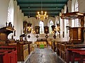 Church interior (Buitenpost)
 Windmill (Buitenpost)
![Rosarium in the Botanische Tuin De Kruidhof [nl]](http://upload.wikimedia.org/wikipedia/commons/5/56/De_Kruidhof_Buitenpost_rosarium.jpg)


Transportation
References
- "Kerncijfers wijken en buurten 2021". Central Bureau of Statistics. Retrieved 29 March 2022.
two entries
- "Postcodetool for 9285JA". Actueel Hoogtebestand Nederland (in Dutch). Het Waterschapshuis. Retrieved 29 March 2022.
- Villages Archived 2017-04-22 at the Wayback Machine - Achtkarspelen (in Dutch)
- "Botanische Tuin De Kruidhof". Museum.nl (in Dutch). Retrieved 29 March 2022.
- "Buitenpost". Plaatsengids (in Dutch). Retrieved 29 March 2022.
- "Buitenpost - (geografische naam)". Etymologiebank (in Dutch). Retrieved 29 March 2022.
- Ronald Stenvert & Sabine Broekhoven (2000). "Surhuisterveen" (in Dutch). Zwolle: Waanders. ISBN 90 400 9476 4. Retrieved 29 March 2022.
- "station Buitenpost". Stationsweb (in Dutch). Retrieved 29 March 2022.
- "De Mûnts". Molen database (in Dutch). Retrieved 29 March 2022.
External links
![]() Media related to Buitenpost at Wikimedia Commons
Media related to Buitenpost at Wikimedia Commons
| Administrative centre |  | |
|---|---|---|
| Villages | ||
| Hamlets |
| |
| Landmarks |
| |
| ||
На других языках
[de] Buitenpost
Buitenpost (westfriesisch Bûtenpost) ist ein Dorf und zugleich Sitz der Gemeinde Achtkarspelen im Norden der Niederlande, in der Provinz Friesland. Es hat 5.710 Einwohner (Stand: 1. Januar 2020)[1] und liegt ungefähr auf halbem Weg zwischen Groningen und Leeuwarden.- [en] Buitenpost
Другой контент может иметь иную лицензию. Перед использованием материалов сайта WikiSort.org внимательно изучите правила лицензирования конкретных элементов наполнения сайта.
WikiSort.org - проект по пересортировке и дополнению контента Википедии