world.wikisort.org - Netherlands
Austerlitz (Dutch pronunciation: [ˈʌu̯stərlɪts]) is a village in the Dutch province of Utrecht. It is a part of the municipality of Zeist, and lies about 6 km east of Zeist.
Austerlitz | |
|---|---|
Village | |
 The Pyramid of Austerlitz | |
|
Flag | |
 | |
 Austerlitz Location in the Netherlands  Austerlitz Austerlitz (Netherlands) | |
| Coordinates: 52°4′43″N 5°19′0″E | |
| Country | Netherlands |
| Province | Utrecht |
| Municipality | Zeist |
| Established | 1806 |
| Area | |
| • Total | 4.34 km2 (1.68 sq mi) |
| Elevation | 13 m (43 ft) |
| Population (2021)[1] | |
| • Total | 1,705 |
| • Density | 390/km2 (1,000/sq mi) |
| Time zone | UTC+1 (CET) |
| • Summer (DST) | UTC+2 (CEST) |
| Postal code | 3711[1] |
| Dialing code | 0343 |
History
In 1804, an army camp was established at the site, called French camp.[3] The town was founded on 17 August 1806 on the location of the camp. It was given its name by King Louis Napoleon of Holland in honour of the victory of his brother, emperor Napoleon in the Battle of Austerlitz. In 1840, it was home to 233 people.[4]
Close to the town, there is an artificial hill called the Pyramid of Austerlitz (52.0904°N 5.3428°E), actually part of the municipality Woudenberg.[5] It used to have a wooden obelisk, but was removed in 1808 due to instability. In 1894, a stone obelisk added to the top.[3]
Gallery
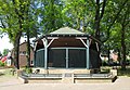 Bandstand in Austerlitz
 Church in Austerlitz
 House in Austerlitz
 Village pump


References
- "Kerncijfers wijken en buurten 2021". Central Bureau of Statistics. Retrieved 26 March 2022.
two entries
- "Postcodetool for 3711AA". Actueel Hoogtebestand Nederland (in Dutch). Het Waterschapshuis. Retrieved 26 March 2022.
- Ronald Stenvert & Chris Kolman (1996). "Austerlitz" (in Dutch). Zwolle: Waanders. ISBN 90 400 9757 7. Retrieved 26 March 2022.
- "Austerlitz". Plaatsengids (in Dutch). Retrieved 26 March 2022.
- "De Pyramide van Austerlitz". Historien (in Dutch). Retrieved 26 March 2022.
Authority control | |
|---|---|
| General | |
| National libraries | |
| Other |
|
This Utrecht location article is a stub. You can help Wikipedia by expanding it. |
Другой контент может иметь иную лицензию. Перед использованием материалов сайта WikiSort.org внимательно изучите правила лицензирования конкретных элементов наполнения сайта.
WikiSort.org - проект по пересортировке и дополнению контента Википедии