world.wikisort.org - Netherlands
Achterhoek (Dutch pronunciation: [ˈɑxtərˌɦuk]) is a hamlet in the Dutch province of Gelderland. It is a part of the municipality of Nijkerk, and lies about 6 km north of Amersfoort.[2]
Achterhoek | |
|---|---|
Hamlet | |
 Farm in Achterhoek | |
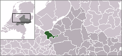 | |
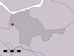 Achterhoek in the municipality of Nijkerk. | |
| Coordinates: 52°13′15″N 5°24′28″E | |
| Country | Netherlands |
| Province | Gelderland |
| Municipality | Nijkerk |
| Area | |
| • Total | 5.83 km2 (2.25 sq mi) |
| Population (2021)[1] | |
| • Total | 240 |
| • Density | 41/km2 (110/sq mi) |
| Time zone | UTC+1 (CET) |
| • Summer (DST) | UTC+2 (CEST) |
| Postal code | 3861[1] |
| Dialing code | 033 |
It was first mentioned in 1608 as "in den Achterhoeck", and means "far away corner".[3] The postal authorities have placed it under Nijkerk.[4] It has no place name signs. In 1840, Achterhoek and De Veenhuis had a combined population of 190 people. Nowadays, Achterhoek consists of about 30 houses.[5]
References
- "Kerncijfers wijken en buurten 2021". Central Bureau of Statistics. Retrieved 23 March 2022.
Combined listing with De Veenhuis
- ANWB Topografische Atlas Nederland, Topografische Dienst and ANWB, 2005.
- "Achterhoek - (geografische naam)". Etymologiebank (in Dutch). Retrieved 23 March 2022.
- "Postcode 3861 in Nijkerk". Postcode bij adres (in Dutch). Retrieved 23 March 2022.
- "Achterhoek (Nijkerk)". Plaatsengids (in Dutch). Retrieved 23 March 2022.
This Gelderland location article is a stub. You can help Wikipedia by expanding it. |
Текст в блоке "Читать" взят с сайта "Википедия" и доступен по лицензии Creative Commons Attribution-ShareAlike; в отдельных случаях могут действовать дополнительные условия.
Другой контент может иметь иную лицензию. Перед использованием материалов сайта WikiSort.org внимательно изучите правила лицензирования конкретных элементов наполнения сайта.
Другой контент может иметь иную лицензию. Перед использованием материалов сайта WikiSort.org внимательно изучите правила лицензирования конкретных элементов наполнения сайта.
2019-2026
WikiSort.org - проект по пересортировке и дополнению контента Википедии
WikiSort.org - проект по пересортировке и дополнению контента Википедии