world.wikisort.org - Nepal
Nijgadh (Nepali: निजगढ, officially Nijgadh Municipality), is a town and municipality in Nepal, located in Bara District of the Madhesh Province (previously Central Development Region). The municipality was formed in May 2014 by merging Nijgadh VDC with Ratnapuri VDC and Bharatganj Singaul VDC.[1][2][3] According to the preliminary report of 2021 Nepalese census, the population of the municipality is 36,491, the fifth highest in the district.[4] It is located 135 kilometres (84 mi) south of the capital, Kathmandu, and 31 kilometres (19 mi) north of the district headquarter, Kalaiya. The Mahendra highway runs through the municipality. The nearest domestic airport, Simara Airport, is 24 kilometres (15 mi) away from the town.
Nijgadh
निजगढ नगरपालिका | |
|---|---|
Municipality | |
| Nijgadh Municipality | |
 | |
 Logo | |
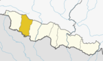
 Nijgadh Location in Madhesh Province  Nijgadh Nijgadh (Nepal) | |
| Coordinates: 27.20°N 85.14°E | |
| Country | |
| Province | Madhesh |
| District | Bara |
| No. of Wards | 13 |
| Government | |
| • Body | Nigadh Municipality Government |
| • Mayor | Surath Puri (UML) |
| • Deputy Mayor | Som Maya Theeng (UML) |
| Area | |
| • Total | 289.4 km2 (111.7 sq mi) |
| Elevation | 192 m (630 ft) |
| Population (2021) | |
| • Total | 36,491 |
| • Density | 130/km2 (330/sq mi) |
| Time zone | UTC+5:45 (NST) |
| Postal code | 44401 |
| Area code | 053 |
| Website | nijgadhmun |
Geography
Nijgadh is located in the northern part of Bara district. It is surrounded by Jitpursimara Sub-Metropolitan in the west, Kolhabi municipality in the south, Bakaiya Rural Municipality of Makwanpur district in the north and Gujara municipality of Rautahat district in the east. The Mahendra Highway runs through the town.
There municipality is divided into 13 wards.
Demographics
According to 2021 Nepal Census, Nijgadh has a population of 36,491 persons (188,006 male and 18,585 female) living in 7,931 individual households.[4]
At the time of the 2011 Nepal Census, the town had a population of 19,617 persons (9,528 male and 10,089 female) living in 3,982 individual households.[5]
Administration
In the 2017 Nepalese local election, Suresh Khanal of Nepali Congress and Lila Devi Lamichhane of Communist Party of Nepal (Unified Marxist–Leninist) were elected as the Mayor and Deputy Mayor of the municipality respectively.[6] They were replaced by Surath Puri and Som Maya Theeng of CPN (UML) in the 2022 Nepalese local elections, who serve currently in the posts.[7]
Proposed international airport
The town has been selected as a site for an international airport that could handle 15 million passengers and even accommodate the super-jumbo Airbus A380 after the first phase of construction. As of April 2011, a feasibility study of the report was completed. The report stated that the airport would cover 3,000 hectares of land: 2,000 hectares for airport and the remaining 1,000 for the airport city.
Education
There are one multi faculty governmental university campus (Gauri Shankar Campus), seven community schools, 20 basic education schools and 12 private schools in the town.[8]
Notable people
- Purusottam Poudel, politician
- Ram Krishna Dhakal, musician
References
- [निजगढको परिचय (Short Description About Nijgadh)] Archive index at the Wayback Machine Nijgadh News
- 72 new municipalities announced Archived June 18, 2014, at the Wayback Machine My Republica
- Govt announces 72 new municipalities Archived 2014-10-06 at the Wayback Machine The Kathmandu Post
- "Census Nepal 2021". censusnepal.cbs.gov.np. Retrieved 2022-10-12.
- "Nepal Census 2001". Nepal's Village Development Committees. Digital Himalaya. Archived from the original on October 12, 2008. Retrieved 21 September 2008.
- Republica. "Forum wins in Patarauta Municipality, RJP clinches Deputy Mayoral post". My Republica. Retrieved 2022-10-12.
- "Nijgadh Municipality - Election 2079 | Results and Updates | Local Election of Nepal 2079 - Bara, Madhesh Pradesh | Ekantipur Election". election.ekantipur.com. Retrieved 2022-10-12.
- "Brief Introduction | Office of Nijgadh Municipality". www.nijgadhmun.gov.np. Retrieved 2022-10-12.
External links
- About Nijgadh
- Nijgadh on Facebook
- UN map of the municipalities of Bara District
- निजगढको परिचय (Short Description About Nijgadh) - Nijgadh News
- Nijgadh on Facebook
Bara District | ||
|---|---|---|
Headquarter: Kalaiya | ||
| Sub-Metropolitan Cities |
|  |
| Municipalities |
| |
| Rural municipalities |
| |
Administrative divisions of Nepal | ||
На других языках
[de] Nijgadh
Nijgadh (Nepali .mw-parser-output .Deva{font-size:120%}@media all and (min-width:800px){.mw-parser-output .Deva{font-size:calc(120% - ((100vw - 800px)/80))}}@media all and (min-width:1000px){.mw-parser-output .Deva{font-size:100%}}बर्दघाट .mw-parser-output .Latn{font-family:"Akzidenz Grotesk","Arial","Avant Garde Gothic","Calibri","Futura","Geneva","Gill Sans","Helvetica","Lucida Grande","Lucida Sans Unicode","Lucida Grande","Stone Sans","Tahoma","Trebuchet","Univers","Verdana"}Nijgadh) ist eine Stadt (Munizipalität) im östlichen Terai Nepals im Distrikt Bara.- [en] Nijgadh
Другой контент может иметь иную лицензию. Перед использованием материалов сайта WikiSort.org внимательно изучите правила лицензирования конкретных элементов наполнения сайта.
WikiSort.org - проект по пересортировке и дополнению контента Википедии