world.wikisort.org - Nepal
Namkha (Nepali: नाम्खा) is the largest rural municipality (by area) of Nepal located in Humla District of Karnali Province.[1]
Namkha
नाम्खा | |
|---|---|
Rural municipality | |
 Limi valley in Namkha RM | |
 Divisional map of Namkha RM | |
 Namkha Location in Nepal  Namkha Namkha (Nepal) | |
| Coordinates: 30°3′36″N 81°27′36″E | |
| Country | |
| Province | Karnali |
| District | Humla |
| No. of wards | 6 |
| Established | 10 March 2017 |
| Government | |
| • Type | Rural council |
| • Chairperson | Mr. Vishnu Bahadur Tamang |
| • Vice-chairperson | Mr. Pema Tamang |
| Area | |
| • Total | 2,419.64 km2 (934.23 sq mi) |
| • Rank | 1st (largest RM of Nepal) |
| Population (2011) | |
| • Total | 3,900 |
| • Density | 1.6/km2 (4.2/sq mi) |
| Time zone | UTC+5:45 (NST) |
| Headquarters | Muchu |
| Website | namkhamun |
The total area of the rural municipality is 2,419.64 square kilometres (934.23 sq mi) and total population is 3900 individuals (as of 2011 Nepal census) only. The rural municipality is divided into 6 wards.[2]
The rural municipality was established on 10 March 2017, when Government of Nepal restricted all old administrative structure (Village development committee) and announced 744 local level units (although the number increased to 753 later) as per the new constitution of Nepal 2015.[3][4]
Hepka, Khagalgaun, Muchu and Limi Village development committees were incorporated to form this new rural municipality. The headquarters of the municipality is situated at Yalwang (Muchu).[2]
| Ward No. | Village | Area (km2) | Population (2011) |
|---|---|---|---|
| 1 | Hepka | 177.72 | 1057 |
| 2 | Khagalgaun North | 191.76 | 495 |
| 3 | Khagalgaun South | 94.08 | 428 |
| 4 | Muchu East (Yalbang) | 586.25 | 456 |
| 5 | Muchu West | 168.54 | 460 |
| 6 | Limi | 1201.29 | 904 |
| Namkha | 2419.64 | 3900 |
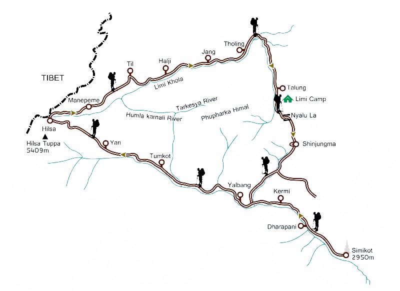
Namkha RM is located in the most North-west part of Nepal in Humla District of Karnali Province. It is surrounded by Tibet (China) from North and West. Geographically Namkha is a difficult terrain which is also an isolated region which is still not connected by road with District headquarter Simikot. It is totally located on Himalayas. Some villages of Limi is located across the himalayas. The region is known for Trekking. There is trekking route connecting Simikot to Limi, Muchu and Yalwang.[5]

References
- "स्थानीय तहहरुको विवरण" [Details of the local level bodies]. www.mofald.gov.np/en (in Nepali). Ministry of Federal Affairs and Local Development. Archived from the original on 31 August 2018. Retrieved 17 July 2018.
- "District Corrected Last for RAJAPATRA" (PDF). www.mofald.gov.np. Retrieved 17 July 2018.
- "New local level structure comes into effect from today". www.thehimalayantimes.com. The Himalayan Times. 10 March 2017. Retrieved 17 July 2018.
- "New local level units come into existence". www.kathmandupost.ekantipur.com. 11 March 2017. Retrieved 18 July 2018.
- "Simikot Trekking". Retrieved 1 January 2021.
External links
Places adjacent to Namkha Rural Municipality | ||||||||||||||||
|---|---|---|---|---|---|---|---|---|---|---|---|---|---|---|---|---|
| ||||||||||||||||
Humla District | ||
|---|---|---|
Headquarters: Simikot | ||
| Rural municipalities: |
|  |
List of municipalities and rural municipalities of Nepal | ||
Другой контент может иметь иную лицензию. Перед использованием материалов сайта WikiSort.org внимательно изучите правила лицензирования конкретных элементов наполнения сайта.
WikiSort.org - проект по пересортировке и дополнению контента Википедии