world.wikisort.org - Nepal
Nagarain is a municipality in Dhanusha District in Province No. 2 of south-eastern Nepal. As of 2011 Nepal census, it has a population of 36,336 living in 6,478 individual households. It was formed by joining Fulgama, Devdiha, old Nagrain, Lagmagadha Guthi and Ghodghans village development committees.[2] The total area of Nagarain municipality is 38.71 km2.[3]
Nagarain Municipality
नगराईन | |
|---|---|
Municipality | |
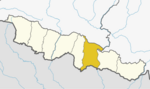
 Local level map of Dhanusha District | |
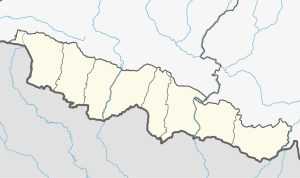 Nagarain Municipality Location in Madhesh Province  Nagarain Municipality Nagarain Municipality (Nepal) | |
| Coordinates: 26°38′20″N 85°54′58″E | |
| Country | |
| Development Region | Central |
| Province | Province No. 2 |
| District | Dhanusha District |
| Literacy rate | |
| Government | |
| • Type | Mayor-council |
| • Mayor | Binay Kumar Yadav (NC) |
| • Deputy Mayor | Ranju Kumari Sah (NC) |
| Area | |
| • Total | 38.71 km2 (14.95 sq mi) |
| Elevation | 64 m (210 ft) |
| Population (2011) | |
| • Total | 36,336 |
| • Density | 940/km2 (2,400/sq mi) |
| • Ethnicities | Maithil Brahmin Kayastha Yadav Sudi Dhanuk Musahar Musalman Dom |
| • Religion | Hinduism Islam |
| Languages | |
| • Local | Maithili |
| • Official | Nepali |
| Time zone | UTC+5:45 (Nepal Time) |
| Postal Code | 45611, 45612[1] |
| Area code(s) | 041 |
| Website | nagrainmun.gov.np |
Education
Nagarain is facilitated by Shree Rajeshwor Nidhi Higher Secondary School, which is run by government. It attracts students from Nagarain as well as the neighbouring villages. Recently, the infrastructure of this school was upgraded and a new classroom block was constructed with the aid from Government of India.[4] Therefore, this building is named "Nepal-Bharat Maitri Bhawan". There are few private schools (run by individuals) which provide education in English medium.

Notable people from Nagarain
- Rajeshwor Nidhi[5]
- Mahendra Narayan Nidhi[6]
- Bimalendra Nidhi[7][8]
- Durgananda Jha[9]
- Smriti Narayan Chaudhary
References
- "POSTAL CODE, Province 2". Postal Services Department, Nepal Government. Retrieved 3 July 2019.
- "National Population and Housing Census 2011" (PDF). Village Development Committee/Municipality. National Planning Commission Secretariat, Central Bureau of Statistics, Government of Nepal. Archived from the original (PDF) on 2014-08-01. Retrieved 3 July 2019.
- "नगराईन नगरपालिकाको वडागत विस्तृत विवरण". Retrieved 3 July 2019.
- "India–Nepal Relations".
- wikipedia same page
- "Mahendra Narayan Nidhi".
- "Ministry of Physical Infrastructure & Transport".
- "Deputy Prime Minister and Ministry of Home". Retrieved 20 July 2016.
- Gellner, David N.; Pfaff-Czarnecka, Joanna; Whelpton, John (2012). Nationalism and Ethnicity in a Hindu Kingdom: The Politics and Culture of Contemporary Nepal. Routledge. p. 520. ISBN 978-9057020896.
External links
- Map of Dhanusha district with updated sub-metropolitan city and municipalities - LGCDP, Ministry of Federal Affairs and Local Development, Government of Nepal
- गाविसहरुको बस्ती विवरण, District Development Committee, Dhanusha
Dhanusha District | ||
|---|---|---|
Headquarter: Janakpur | ||
| Sub-metropolitan cities |
|  |
| Municipalities |
| |
| Rural Municipalities |
| |
Administrative divisions of Nepal | ||
Другой контент может иметь иную лицензию. Перед использованием материалов сайта WikiSort.org внимательно изучите правила лицензирования конкретных элементов наполнения сайта.
WikiSort.org - проект по пересортировке и дополнению контента Википедии