world.wikisort.org - Nepal
Jalapa is a village and also the Village Development Committee of Khotang District in the Sagarmatha Zone of eastern Nepal is located here. At the time of the 1991 Nepal census, it had a population of 2,351 persons living in 448 individual households.[1]
Jalapa, Nepal
जाल्पा | |
|---|---|
Village Development Committee | |
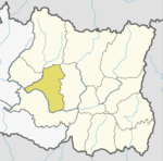
 Jalapa, Nepal Location in Nepal | |
| Coordinates: 27.31°N 86.78°E | |
| Country | |
| Zone | Sagarmatha Zone |
| District | Khotang District |
| Population (1991) | |
| • Total | 2,351 |
| Time zone | UTC+5:45 (Nepal Time) |
Jalapa consists of other villages such as Kharbari, Purano Gau and Ghale Gau. Most maps of Nepali does not indicate these villages.
References
- "Nepal Census 2001". Nepal's Village Development Committees. Digital Himalaya. Archived from the original on 12 October 2008. Retrieved 30 September 2008.
2. Administrative area of Jalapa (Nepal)
External links
Khotang District | ||
|---|---|---|
Headquarter: Diktel | ||
| Urban Municipality |
|  |
| Rural Municipality |
| |
For former VDCs See here | ||
This article about a location in Khotang District, Nepal is a stub. You can help Wikipedia by expanding it. |
Текст в блоке "Читать" взят с сайта "Википедия" и доступен по лицензии Creative Commons Attribution-ShareAlike; в отдельных случаях могут действовать дополнительные условия.
Другой контент может иметь иную лицензию. Перед использованием материалов сайта WikiSort.org внимательно изучите правила лицензирования конкретных элементов наполнения сайта.
Другой контент может иметь иную лицензию. Перед использованием материалов сайта WikiSort.org внимательно изучите правила лицензирования конкретных элементов наполнения сайта.
2019-2025
WikiSort.org - проект по пересортировке и дополнению контента Википедии
WikiSort.org - проект по пересортировке и дополнению контента Википедии