world.wikisort.org - Nepal
Bayarban was a village development committee in the Morang District, Koshi Zone of south-eastern Nepal. It was named for the village of Bayarban Bazar. In 2017 it was absorbed by the newly created Kanepokhari Rural Municipality.
Bayarban
बयरबन | |
|---|---|
Village development committee | |
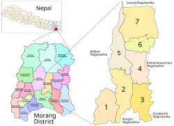 Kanepokhari in Morang District. Bayarban VDC became Wards 3, 4, 6 and 7 | |
| Coordinates: 26.62°N 87.51°E | |
| Country | |
| Zone | Koshi Zone |
| District | Morang District |
| Population (1991) | |
| • Total | 20,230 |
| Time zone | UTC+5:45 (Nepal Time) |
| Postal code | 56606 |
| Area code(s) | 021 |
Location
Bayarban was in Nepal, Eastern Region, Kosī Zone, Morang. It had an elevation of about 107 metres (351 ft).[1] The Köppen climate classification is Cwa : Monsoon-influenced humid subtropical climate.[2]
Population
At the time of the 1991 Nepal census Bayarban had a population of 20,230.[3] The table below shows the populations in 2011 of the wards of Kanepokhari Rural Municipality. Bayarban became Wards 3, 4, 6 and 7 when Kanepokhari was constituted in March 2017.[4]
| Ward | Ward Kendra | Households | 2011 Population | Male | Female | Formed from |
|---|---|---|---|---|---|---|
| 1 | VDC Building Bayarban | 1121 | 4830 | 2281 | 2549 | Hoklabari all wards |
| 2 | VDC Building | 1368 | 5941 | 2758 | 3183 | Keroun Wards 3, 4, 6-9 |
| 3 | Jayanepal Chowk | 1174 | 5232 | 2449 | 2783 | Bayarban Wards 1-5 |
| 4 | Bayarban Bajar | 1174 | 5242 | 2363 | 2879 | Bayarban Wards 6, 7 |
| 5 | Bhousabari | 1558 | 6776 | 3107 | 3669 | Keroun Wards 1, 2, 5 |
| 6 | VDC Building | 1340 | 5771 | 2613 | 3158 | Bayarban Ward 8 |
| 7 | Aitabare Bajar | 948 | 4241 | 1916 | 2325 | Bayarban Ward 9 |
References
- "Bayarban", GeoNames, retrieved 2020-06-14
- "Bayarban, Morang, Kosī Zone, Purwanchal, Nepal", Mindat, retrieved 2020-06-14
- "Nepal Census 2001". Nepal's Village Development Committees. Digital Himalaya. Archived from the original on 12 October 2008. Retrieved 15 December 2008.
- Unit-9: Kanepokhari Gaunpalika (PDF), District Coordination Committee Office : Morang, Nepal, p. 10, retrieved 2020-06-10
Morang District | ||
|---|---|---|
Headquarter: Biratnagar | ||
| Metropolitan City |
|  |
| Municipalities |
| |
| Rural Municipalities |
| |
This article about a location in Morang District, Nepal is a stub. You can help Wikipedia by expanding it. |
Другой контент может иметь иную лицензию. Перед использованием материалов сайта WikiSort.org внимательно изучите правила лицензирования конкретных элементов наполнения сайта.
WikiSort.org - проект по пересортировке и дополнению контента Википедии