world.wikisort.org - Nepal
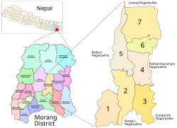
Keroun Bazar is a village in Ward 2 of the Kanepokhari Rural Municipality of the Morang District in Province No. 1 of south-eastern Nepal. Keroun was formerly a Village development committee (VDC), but was incorporated into Kanepokhari when that rural municipality was created in 2017.
Keraun
केरौन | |
|---|---|
Village | |
 Kanepokhari. Keroun is in Ward 2 | |
| Coordinates: 26.573065°N 87.497043°E | |
| Country | |
| Province | Province No. 1 |
| District | Morang District |
| Gaunpalika | Kanepokhari |
| Population (1991) | |
| • Total | 10,802 |
| Time zone | UTC+5:45 (Nepal Time) |
Location
The Keroun VDC was in Nepal, Eastern Region, Kosī Zone, Morang. It is at an elevation of about 105 metres (344 ft).[1] Google Maps shows Keroun Bazar on the Kanepokhari-Rangeli road to the north of Daleli and the south of Ramailo.[2]
References
- "Keroun", GeoNames, retrieved 2020-06-13
- "Keroun Bazar", Google Maps, retrieved 2020-06-13
Morang District | ||
|---|---|---|
Headquarter: Biratnagar | ||
| Metropolitan City |
|  |
| Municipalities |
| |
| Rural Municipalities |
| |
This article about a location in Morang District, Nepal is a stub. You can help Wikipedia by expanding it. |
Текст в блоке "Читать" взят с сайта "Википедия" и доступен по лицензии Creative Commons Attribution-ShareAlike; в отдельных случаях могут действовать дополнительные условия.
Другой контент может иметь иную лицензию. Перед использованием материалов сайта WikiSort.org внимательно изучите правила лицензирования конкретных элементов наполнения сайта.
Другой контент может иметь иную лицензию. Перед использованием материалов сайта WikiSort.org внимательно изучите правила лицензирования конкретных элементов наполнения сайта.
2019-2026
WikiSort.org - проект по пересортировке и дополнению контента Википедии
WikiSort.org - проект по пересортировке и дополнению контента Википедии