world.wikisort.org - Morocco
Tangier-Tétouan (Berber: Tanja-Tiṭṭawin, ⵜⴰⵏⵊⴰ-ⵜⵉⵟⵟⴰⵡⵉⵏ; Arabic: طنجة تطوان) was formerly one of the sixteen regions of Morocco from 1997 to 2015. It covered an area of 11,570 km²[1] and had a population of 3,157,075.[2] The capital was Tangier. In 2015, Al Hoceïma Province from Taza-Al Hoceima-Taounate was added to it to form the region of Tanger-Tétouan-Al Hoceïma.
Tangier-Tétouan
طنجة تطوان Tanjah-Tituwahn ⵜⴰⵏⵊⴰ-ⵜⵉⵟⵟⴰⵡⵉⵏ Tanja-Tiṭṭawin | |
|---|---|
Region | |
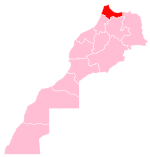
 Location in Morocco | |
| Coordinates: 35°46′N 5°48′W | |
| Country | |
| Created | 1997 |
| Abolished | September 2015 |
| Capital | Tangier |
| Area | |
| • Total | 11,570 km2 (4,470 sq mi) |
| Population (2014 census) | |
| • Total | 3,157,075 |
| Time zone | UTC+0 (WET) |
| • Summer (DST) | UTC+1 (WEST) |
Geography

The region has a coastline on the west formed by the Atlantic Ocean, on the north by the Strait of Gibraltar and on the east by the Mediterranean Sea. It borders the regions of Gharb-Chrarda-Béni Hssen and Taza-Al Hoceima-Taounate to the south, and also has a border with the Spanish exclave of Ceuta.
Administrative divisions
The region is made up into the following provinces and prefectures:
- Tangier Sub-Region
- Prefecture of Tangier-Assilah
- Fahs-Anjra Province
- Tétouan Sub-Region
- Prefecture of M'diq-Fnideq
- Chefchaouen Province
- Larache Province
- Ouezzane Province
- Tétouan Province
References
- Tangier-Tetouan, Morocco.com, accessed 7 February 2013
- 2014 census
Capital: Tangier | ||
| Prefectures and provinces |
|  |
| Cities |
| |
Regions of Morocco | ||
|---|---|---|
| from 2015 |
| |
| 1997–2015 |
| |
| 1971–1997 |
| |
Regions falling partly (*) or entirely (**) within the disputed territory of Western Sahara | ||
Authority control | |
|---|---|
| General |
|
| Other |
|
Текст в блоке "Читать" взят с сайта "Википедия" и доступен по лицензии Creative Commons Attribution-ShareAlike; в отдельных случаях могут действовать дополнительные условия.
Другой контент может иметь иную лицензию. Перед использованием материалов сайта WikiSort.org внимательно изучите правила лицензирования конкретных элементов наполнения сайта.
Другой контент может иметь иную лицензию. Перед использованием материалов сайта WikiSort.org внимательно изучите правила лицензирования конкретных элементов наполнения сайта.
2019-2026
WikiSort.org - проект по пересортировке и дополнению контента Википедии
WikiSort.org - проект по пересортировке и дополнению контента Википедии