world.wikisort.org - Mexico
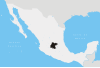
Celaya ([seˈlaja]; ![]() pronunciation (help·info)) is a city and its surrounding municipality in the state of Guanajuato, Mexico, located in the southeast quadrant of the state. It is the third most populous city in the state, with a 2005 census population of 310,413. The municipality for which the city serves as municipal seat, had a population of 415,869. The city is located in the geographic center of the municipality, which has an areal extent of 553.18 km2 (213.58 sq mi) and includes many smaller outlying communities, the largest of which are San Miguel Octopan, Rincón de Tamayo and San Juan de la Vega.
pronunciation (help·info)) is a city and its surrounding municipality in the state of Guanajuato, Mexico, located in the southeast quadrant of the state. It is the third most populous city in the state, with a 2005 census population of 310,413. The municipality for which the city serves as municipal seat, had a population of 415,869. The city is located in the geographic center of the municipality, which has an areal extent of 553.18 km2 (213.58 sq mi) and includes many smaller outlying communities, the largest of which are San Miguel Octopan, Rincón de Tamayo and San Juan de la Vega.
Celaya | |
|---|---|
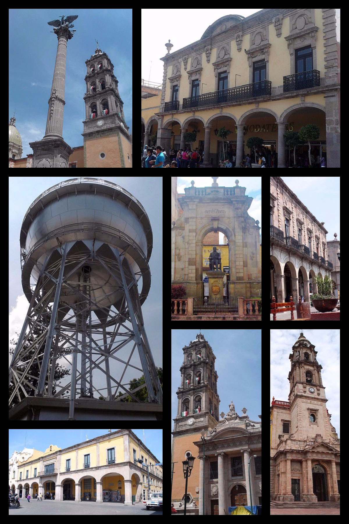 Ángel de la Independencia, Andador Guadalupe, Bola de agua, Estatua a Tresguerras, Portal Colunga, Catedral de San Francisco, Iglesia de la Virgen del Carmen y Palacio Municipal. | |
 Seal | |
| Motto(s): "De Forti Dulcedo" (La Dulzura del Fuerte) (Out of the strong, something sweet<Judges 14:14>) | |
Celaya | |
| Coordinates: 20°31′23″N 100°48′50″W | |
| Country | |
| State | Guanajuato |
| Municipality | Celaya |
| Foundation | October 12, 1570 |
| Founded by | Martín Enríquez de Almanza |
| Government | |
| • Mayor | Javier Mendoza Márquez |
| Area | |
| • Total | 553.18 km2 (213.58 sq mi) |
| Elevation | 1,767 m (5,797 ft) |
| Population (2012) | |
| • Total | 468,469 |
| • Density | 850/km2 (2,200/sq mi) |
| Time zone | UTC-6 (Central Standard Time) |
| • Summer (DST) | UTC-5 (Central Daylight Time) |
| Postal code | 38000 - 38159 |
| Area code | 461 |
| Airport | Aeropuerto Nacional Capitán Rogelio Castillo |
| Website | http://www.celaya.gob.mx |
There are many smaller towns around Celaya including Rincón de Tamayo, Tarimoro, Salvatierra, La Moncada, Panales Jamaica (Cañones), Panales Galera, La Calera, La Estancia, La Noria, Los Fierros, El Acebuche, Cacalote, and Charco Largo.
History


Celaya was a frontier region between the Purépecha and the Chichimecas.[1]
General Álvaro Obregón defeated Pancho Villa in the Battle of Celaya in 1915, as referred by Martínez[2] Celaya was also the Guanajuato state capital for a short period.[3][circular reference]
An explosion in a gunpowder and fireworks warehouse in September, 1999, killed over 60 people and injured over 300 people. [4][5]
On 23 May 2022, eleven people were murdered in a massacre linked to the Mexican drug war.[6]
Climate
| Climate data for Celaya | |||||||||||||
|---|---|---|---|---|---|---|---|---|---|---|---|---|---|
| Month | Jan | Feb | Mar | Apr | May | Jun | Jul | Aug | Sep | Oct | Nov | Dec | Year |
| Record high °C (°F) | 36.0 (96.8) |
33.0 (91.4) |
39.0 (102.2) |
39.0 (102.2) |
38.5 (101.3) |
38.0 (100.4) |
33.5 (92.3) |
33.0 (91.4) |
33.0 (91.4) |
34.0 (93.2) |
35.0 (95.0) |
34.0 (93.2) |
39.0 (102.2) |
| Average high °C (°F) | 24.7 (76.5) |
26.1 (79.0) |
28.5 (83.3) |
30.2 (86.4) |
31.3 (88.3) |
29.4 (84.9) |
27.3 (81.1) |
27.4 (81.3) |
27.1 (80.8) |
26.7 (80.1) |
26.5 (79.7) |
25.3 (77.5) |
27.5 (81.5) |
| Daily mean °C (°F) | 15.1 (59.2) |
16.2 (61.2) |
18.5 (65.3) |
20.6 (69.1) |
22.4 (72.3) |
22.1 (71.8) |
20.8 (69.4) |
20.7 (69.3) |
20.4 (68.7) |
19.0 (66.2) |
17.6 (63.7) |
16.2 (61.2) |
19.1 (66.4) |
| Average low °C (°F) | 5.5 (41.9) |
6.4 (43.5) |
8.4 (47.1) |
11.0 (51.8) |
13.6 (56.5) |
14.9 (58.8) |
14.3 (57.7) |
14.0 (57.2) |
13.6 (56.5) |
11.4 (52.5) |
8.7 (47.7) |
7.0 (44.6) |
10.7 (51.3) |
| Record low °C (°F) | −3.5 (25.7) |
−3.5 (25.7) |
−3.0 (26.6) |
1.0 (33.8) |
6.0 (42.8) |
7.0 (44.6) |
8.5 (47.3) |
6.5 (43.7) |
3.0 (37.4) |
3.5 (38.3) |
−1.5 (29.3) |
−3.5 (25.7) |
−3.5 (25.7) |
| Average precipitation mm (inches) | 12.5 (0.49) |
5.7 (0.22) |
8.5 (0.33) |
14.6 (0.57) |
31.0 (1.22) |
97.5 (3.84) |
140.6 (5.54) |
120.7 (4.75) |
94.3 (3.71) |
36.3 (1.43) |
14.5 (0.57) |
8.8 (0.35) |
585.0 (23.03) |
| Average precipitation days (≥ 0.1 mm) | 2.2 | 1.2 | 1.5 | 2.5 | 5.3 | 10.7 | 13.8 | 12.8 | 9.8 | 4.9 | 2.2 | 1.8 | 68.7 |
| Source: Servicio Meteorologico Nacional[7] | |||||||||||||
Education
- Centro Pedagogico de Celaya
- Colegio Arturo Rosenblueth
- Colegio Marista
- Colegio Nuevo Continente Bajío Celaya Campus[8]
• Complejo Educativo Ignacio Allende
- Colegio Mexico[9]
- Escuela Bilingue Guilford[10]
- Instituto Andersen[11]
- Instituto Bilingue Oxford
- Instituto Británico de Celaya (BIC)
- Instituto Educativo Rosa G. de Carmona
- Instituto Kipling
- Instituto Sir Winston Churchill[12]
- Instituto Tecnologico de Celaya[13]
- Instituto Tecnologico de Roque[14]
- Instituto Universitario del Centro de México (UCEM)
- Tecnologico de Monterrey
- Universidad de Celaya[15]
- Universidad de Guanajuato
- Universidad de Itesba[16]
- Universidad Lasallista Benavente[17]
- Universidad Latina de Mexico[18]
- Westminster Royal College
Attractions
Ball of Water
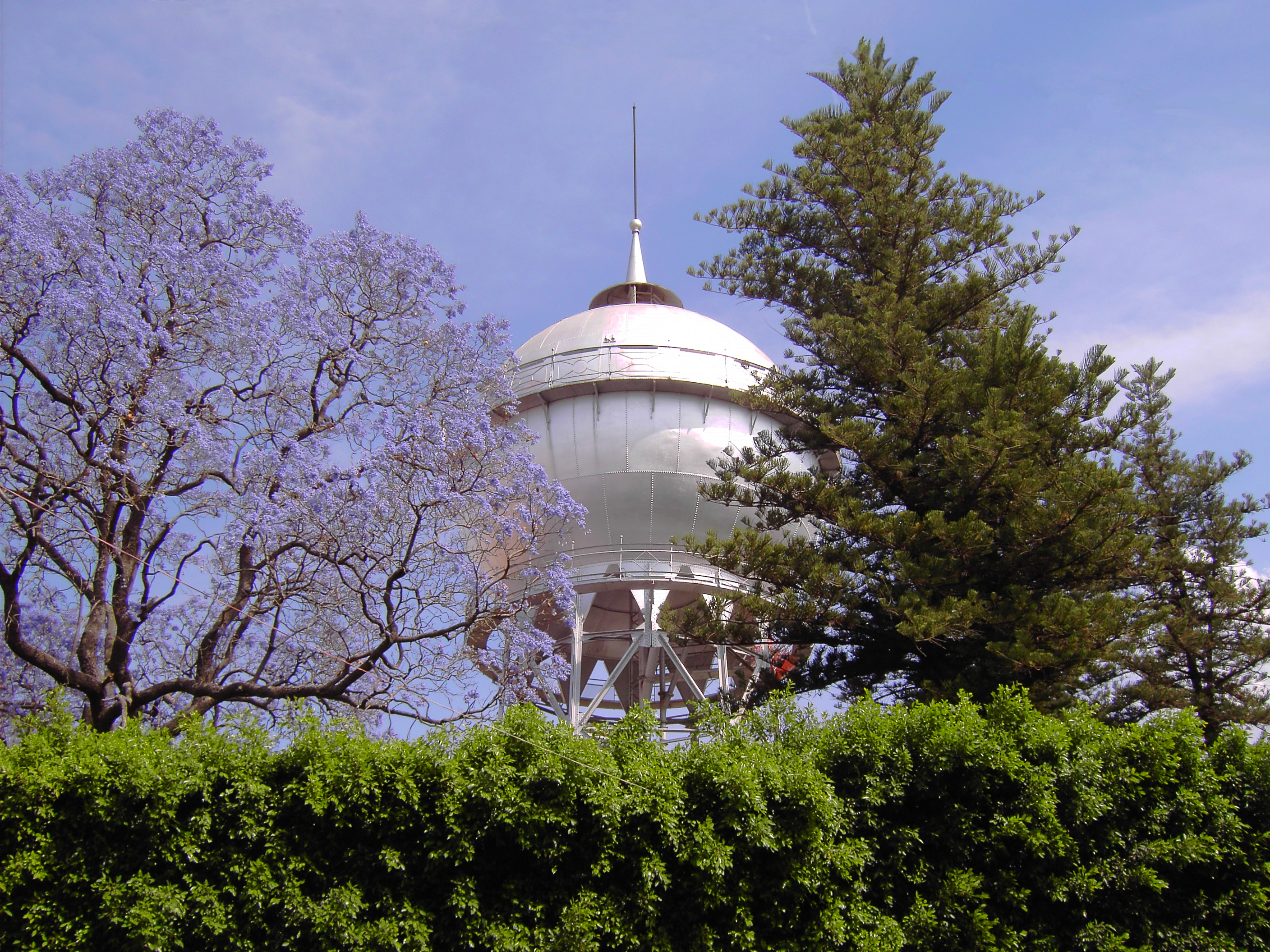
The Ball of Water reservoir has been a city icon since 1908; it continues to supply water to portions of downtown. The tank was manufactured in Germany and assembled on site, and is unique in being assembled using rivets rather than welds. It is believed[by whom?] to be the only one of its kind with a spherical shape (it is rumored[weasel words] that there was another similar water ball in Stuttgart, Germany that was destroyed during the Second World War). Traditionally, locals tell visitors that it is filled with cajeta, taking them to visit the "Bola del Agua" on Sundays, the traditional day for visiting the Independencia Lane. A plaque at the base of the water tower features the legend (in Spanish):
'"This tower was built at the expense of the city municipality in 1910 and officially opened on 15 September, the day of the anniversary of the proclamation of the independence of Mexico as a state governor Mr. Don Joaquín González Obregón, who gave full moral support to the construction.'s work and everything related to the provision of drinking water, was designed and conducted by the district political head Mr. Don Perfecto I. Aranda, its total cost, including piping limited to two circuits, was $ 161,520.84 (mexican old) pesos ".
The work was carried out under the command of German Enrique Schöndube, although it is known that payment for the construction took ten years due to the start of the Mexican Revolution, so it was paid once the new government established. During the Mexican Revolution, Villa's officers thought the hydraulic tower had such a large amount of water that destroying it would drown the population of Celaya. One of Villa's generals ordered his artillery to destroy it. Captain Gustavo Duron, in charge of a 75mm battery, followed the orders but shot around the tower, avoiding it and protecting the monument, as mentioned by local historian Herminio Martínez. The construction resulted in the neglect of the people handing out water at home from the mayor's office called water carriers. Commercial advertising on its surface was allowed for several years to cover the costs of the reservoir, ending on September 8, 1980 when, in celebration of upcoming 410th Anniversary of the Foundation of Celaya, the mayor in charge decreed that the Ball of Water would be a symbol that would represent the city, and the placement of advertisements was banned.
Cuisine
Celaya is also known for the artisanal production of cajeta, a type of milk candy.[citation needed]
Transportation
The Celaya Airport had (as of January 22, 2007) commercial flights to Santiago de Querétaro and connections from there to other destinations; these services were dropped in 2008.[citation needed] Celaya lies along the El Paso Spur of the Pan-American Highway which is known locally as Mexican Federal Highway 45.[citation needed]
People
- Marta Sahagún de Fox (b. April 10, 1953), former Mexican First Lady and wife of President Vicente Fox, lived in Celaya and unsuccessfully ran for mayor
- Miguel Martínez (b. September 29, 1921), Musician, composer and songwriter. Considered the father of the modern mariachi trumpet.
- Francisco Eduardo Tresguerras (b. October 13, 1759, d. August 3, 1833), Architect and painter. Designed the El Carmen church in Celaya.
- Joshua Ilika Brenner (b. September 14, 1976) Olympic swimmer
- Liliana Ibáñez (b. January 30, 1991) Olympic swimmer
- Raúl Velasco (b. April 24, 1933, d. November 26, 2006) Entertainer and TV Producer. Was the host of the TV program Siempre en Domingo.
- Octavio Ocampo (b. February 28, 1943) Painter known for his "metamorphosis" style.
- Mauricio Ochmann (b. November 16, 1977), Actor.
- Ever Guzmán (b. March 15, 1988), footballer.
- José Juan Vázquez (b. 14 March 1988), Mexican footballer, who currently plays in Club Leon.
- David Roberto Bárcena Ríos (26 December 1941 – 22 February 2017) was a Mexican equestrian who competed at five Olympic Games, winning a bronze medial in the Team Event at his fifth Olympics
- Lalo Duron (b. September 6, 1963). Author of "Alive & Well!", "¿Jubilarme? Ni de chiste", writer, and creator of "Creado en México", and "Emprende" movements in Mexico.
Sister cities
 Carrboro, North Carolina, United States
- Chapel Hill, North Carolina, United States
 Guernica, Spain
 Oaxaca, Mexico
- Tuxtla Gutiérrez, Mexico
See also
- Club Celaya a football club from the 1950s that was resurrected in 2003
- Atlético Celaya a former association football team
- Auditorio Tresguerras
- Estadio Miguel Alemán
- Roman Catholic Diocese of Celaya
- Immaculate Conception Cathedral, Celaya
References
- Peter Gerhard, A Guide to the Historical Geography of New Spain (Cambridge: Cambridge University Press, 1972), p. 64
- Martínez A, JA (2019). Los Combates de Celaya: Crónicas y Testimonios.
- "Municipio de Celaya".
- "Domingo Negro - U-69 CRUZ ROJA CELAYA". Archived from the original on 2011-07-28. Retrieved 2011-01-30.
- "World at a Glance". www.disasterrelief.org. Archived from the original on 17 August 2000. Retrieved 17 January 2022.
- "Asesinadas al menos 11 personas en un ataque en Celaya". 24 May 2022.
- NORMALES CLIMATOLÓGICAS 1971-2000 Archived 2013-02-19 at archive.today, National Meteorological Service of Mexico. Retrieved August 4, 2012.
- "Nuevo Continente Bajío: Contacto". nuevocontinentebajio.edu.mx.
- "Colegio México Celaya – La Verdad Os Hará Libres". www.colegio-mexico.edu.mx.
- "Escuela Guilford". 18 December 2007. Archived from the original on 18 December 2007.
- "Instituto Hans Christian Andersen". www.institutoandersen.edu.mx.
- . 22 July 2011 https://web.archive.org/web/20110722224624/http://www.institutowinston.edu.mx/. Archived from the original on 22 July 2011.
{{cite web}}: Missing or empty|title=(help) - "Portal Web ITCelaya - Site". www.itc.mx.
- "Instituto Tecnológico de Roque". 21 July 2008. Archived from the original on 21 July 2008.
- "Inicio - Universidad de Celaya". www.udec.edu.mx.
- "UNITESBA - Universidad". www.unitesba.edu.mx.
- "Universidad Lasallista Benavente". www.ulsab.edu.mx.
- "Universidad Latina de Mexico - Offline". 28 February 2010. Archived from the original on 28 February 2010.
Sources
- Link to tables of population data from Census of 2005 INEGI: Instituto Nacional de Estadística, Geografía e Informática
- Guanajuato Enciclopedia de los Municipios de México
External links
- Official website
- A casi 100 años de la Bola de Agua (Near the century of "Ball of Water")
- PODCelaya.com Business Virtual Directory
- Diócesis de Celaya
- Domingo Negro Explosion
Places adjacent to Celaya | ||||||||||||||||
|---|---|---|---|---|---|---|---|---|---|---|---|---|---|---|---|---|
| ||||||||||||||||
Guanajuato (capital) | ||
| Municipalities |
|  |
Authority control | |
|---|---|
| General | |
| National libraries | |
| Other |
|
На других языках
[de] Celaya
Mit 340.387 Einwohnern (Stand 2010)[1] ist Celaya die drittgrößte Stadt im mexikanischen Bundesstaat Guanajuato. Das die Stadt umgebende Municipio heißt ebenfalls Celaya und hat (einschließlich der Stadt) 468.469 Einwohner. Die in einem Talbecken des zentralen Hochlandes gelegene Stadt liegt etwa 1750 Meter über dem Meeresspiegel.- [en] Celaya
[ru] Селая (Гуанахуато)
Села́я (исп. Celaya) — город и административный центр одноимённого муниципалитета в мексиканском штате Гуанахуато. Численность населения, по данным переписи 2010 года, составила 340 387 человек.Другой контент может иметь иную лицензию. Перед использованием материалов сайта WikiSort.org внимательно изучите правила лицензирования конкретных элементов наполнения сайта.
WikiSort.org - проект по пересортировке и дополнению контента Википедии