world.wikisort.org - Mexico
Apatzingán (in full, Apatzingán de la Constitución) is a city and municipal seat of the municipality of Apatzingán in the west-central region of the Mexican state of Michoacán.
Apatzingán | |
|---|---|
City | |
| Apatzingán de la Constitución | |
 Seal | |
| Nicknames: La Perla de Tierra Caliente, Cuna de la Constitución Mexicana | |
 Apatzingán Location of Apatzingán in Mexico Apatzingán Apatzingán (Mexico) | |
| Coordinates: 19°05′19″N 102°21′03″W | |
| Country | Mexico |
| State | Michoacán |
| Municipality | Apatzingán |
| Founded | 1617 |
| Government | |
| • Municipal President | Uriel Chávez Mendoza (PRI) |
| Elevation | 325 m (1,066 ft) |
| Population (2010)[1] | |
| • Total | 99,010 |
| Time zone | UTC-6 (CST) |
| • Summer (DST) | UTC-5 (CDT) |
| Area code(s) | 453 |
| Website | Official Website |
Geography
The Municipality of Apatzingán is located in the Tierra Caliente Valley. It has an area of 1,656.67 km2 (639.64 sq mi), and reported a population of 99,010 (2010).
The city of Apatzingán is the sixth-largest in Michoacán (behind Morelia, Uruapan, Zamora, Lázaro Cárdenas, and Zitacuaro), with a 2015 census population of 128,250 persons.
The major Sierra Madre del Sur mountain range and the municipality of Coalcomán de Vázquez Pallares are to the west.

History
Mexico's Constitution of Apatzingán was signed in the city in 1814, during the Mexican War of Independence in the Viceroyalty of New Spain against the Spanish Empire.
Six federal police officers were charged with murder on August 21, 2019 for their supposed involvement in a police operation that left nine dead on January 6, 2015 in Apatzingán. At least nine people died and several were injured when police fired against members and sympathizers of self-defense groups who had taken over the municipal palace.[2]
Climate
Despite having an annual precipitation of 752 millimetres (29.6 in), Apatzingán has a semi-arid climate (Köppen climate classification BSh) due to its hot temperatures and high evaporation rates.[3]
| Climate data for Apatzingán | |||||||||||||
|---|---|---|---|---|---|---|---|---|---|---|---|---|---|
| Month | Jan | Feb | Mar | Apr | May | Jun | Jul | Aug | Sep | Oct | Nov | Dec | Year |
| Record high °C (°F) | 38.0 (100.4) |
39.0 (102.2) |
42.0 (107.6) |
43.0 (109.4) |
46.5 (115.7) |
44.0 (111.2) |
43.0 (109.4) |
39.5 (103.1) |
39.0 (102.2) |
41.5 (106.7) |
43.0 (109.4) |
37.0 (98.6) |
46.5 (115.7) |
| Average high °C (°F) | 32.3 (90.1) |
33.8 (92.8) |
36.4 (97.5) |
39.0 (102.2) |
40.0 (104.0) |
37.8 (100.0) |
34.7 (94.5) |
34.1 (93.4) |
33.7 (92.7) |
34.1 (93.4) |
34.0 (93.2) |
32.9 (91.2) |
35.2 (95.4) |
| Daily mean °C (°F) | 24.7 (76.5) |
26.0 (78.8) |
28.4 (83.1) |
30.7 (87.3) |
32.7 (90.9) |
31.6 (88.9) |
29.2 (84.6) |
28.5 (83.3) |
28.2 (82.8) |
28.2 (82.8) |
27.3 (81.1) |
25.7 (78.3) |
28.4 (83.1) |
| Average low °C (°F) | 17.1 (62.8) |
18.1 (64.6) |
20.3 (68.5) |
22.4 (72.3) |
25.4 (77.7) |
25.5 (77.9) |
23.6 (74.5) |
22.9 (73.2) |
22.7 (72.9) |
22.2 (72.0) |
20.7 (69.3) |
18.5 (65.3) |
21.6 (70.9) |
| Record low °C (°F) | 8.5 (47.3) |
10.0 (50.0) |
13.0 (55.4) |
13.0 (55.4) |
17.5 (63.5) |
15.0 (59.0) |
17.0 (62.6) |
18.5 (65.3) |
19.0 (66.2) |
14.0 (57.2) |
11.0 (51.8) |
10.0 (50.0) |
8.5 (47.3) |
| Average precipitation mm (inches) | 17.1 (0.67) |
1.1 (0.04) |
0.8 (0.03) |
0.6 (0.02) |
11.2 (0.44) |
129.5 (5.10) |
166.2 (6.54) |
175.2 (6.90) |
148.5 (5.85) |
81.9 (3.22) |
14.6 (0.57) |
5.2 (0.20) |
751.9 (29.60) |
| Average precipitation days (≥ 0.1 mm) | 1.3 | 0.4 | 0.3 | 0.2 | 1.6 | 11.4 | 14.6 | 14.3 | 12.3 | 5.6 | 1.5 | 0.6 | 64.1 |
| Source: Servicio Meteorologico Nacional[4] | |||||||||||||
See also
- Immaculate Conception Cathedral, Apatzingán
References
- "Principales resultados por localidad 2010 (ITER)". Instituto Nacional de Estadística y Geografía. 2010.
- "Detienen a seis policías federales por matanza de 2015 en Apatzingán" [Arrest six federal police for killing in 2015 in Apatzingan], Informador.mx (in Spanish), August 22, 2019, retrieved August 22, 2019
- Kottek, M.; J. Grieser; C. Beck; B. Rudolf; F. Rubel (2006). "World Map of the Köppen-Geiger climate classification updated" (PDF). Meteorol. Z. 15 (3): 259–263. doi:10.1127/0941-2948/2006/0130. Retrieved 28 August 2012.
- NORMALES CLIMATOLÓGICAS 1971-2000 (in Spanish). National Meteorological Service of Mexico. Retrieved August 28, 2012.
Sources
- Link to tables of population data from Census of 2005 Instituto Nacional de Estadística, Geografía e Informática (INEGI)
- Michoacán Enciclopedia de los Municipios de México
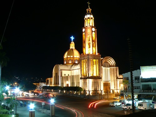
- " Photograph from Apatzingan's main church
External links
- Ayuntamiento de Apatzingán Official website
- Apatzingan Map
Morelia (capital) | ||
| Municipalities and (municipal seats) |
|  |
| Protected areas |
| |
Authority control | |
|---|---|
| General | |
| National libraries | |
На других языках
- [en] Apatzingán
[es] Apatzingán de la Constitución
Apatzingán de la Constitución es una ciudad mexicana ubicada en el estado de Michoacán de Ocampo. Ésta fue fundada en 1617 por Franciscanos y Agustinos y fue un pueblo hasta 1883, fecha en que oficialmente se convierte en una ciudad. Es cabecera del municipio de Apatzingán y se localiza en la Tierra Caliente Mexicana de la cuál es la ciudad más poblada al contar según datos del Censo de Población y Vivienda del año 2020 del INEGI con un total de 102,362 habitantes por encima de su vecina, la ciudad de Nueva Italia y la ciudad guerrerense de Ciudad Altamirano. Por su población es la 4.ª ciudad más poblada del estado de Michoacán y la 128.ª ciudad más poblada de México.Другой контент может иметь иную лицензию. Перед использованием материалов сайта WikiSort.org внимательно изучите правила лицензирования конкретных элементов наполнения сайта.
WikiSort.org - проект по пересортировке и дополнению контента Википедии